METAR & TAF P01
P01 does not publish a METAR.
Showing the nearest reporting station: KBXK (BUCKEYE MUNI) · 58.9 NM away. Conditions at P01 may differ.
METAR · KBXK
Observed 12:55Z
KBXK 271255Z AUTO 24005KT 10SM CLR 31/18 A2988 RMK AO2
- Wind
- 240° @ 5 kt
- Visibility
- 10 SM
- Temp / Dew
- 31°C / 18°C
- Altimeter
- 29.88 inHg
- Clouds
- CLR
- Density alt
- 3,768 ft
- Ceiling
- Unlimited
- Rules
- VFR
Airport info & contacts
Manager on record, flight service, ARTCC, attendance schedule and pattern altitude — published by the FAA and refreshed every 28 days.
Location
- From city
- 5 NM N
- VFR sectional
- PHOENIX
- ARTCC
- ZAB · ALBUQUERQUE
- NOTAM facility
- PRC (NOTAM-D)
Airport manager
- Name
- ANNA STEINER
- Phone
- 520-627-3951
- Address
- 201 N. STONE AVE., TUCSON AZ 85701-1215
Flight service · Hours
- FSS PRC
- PRESCOTT1-800-WX-BRIEF
- Attendance
- Unattended
Frequencies
Tap any row to copy the frequency to your clipboard.
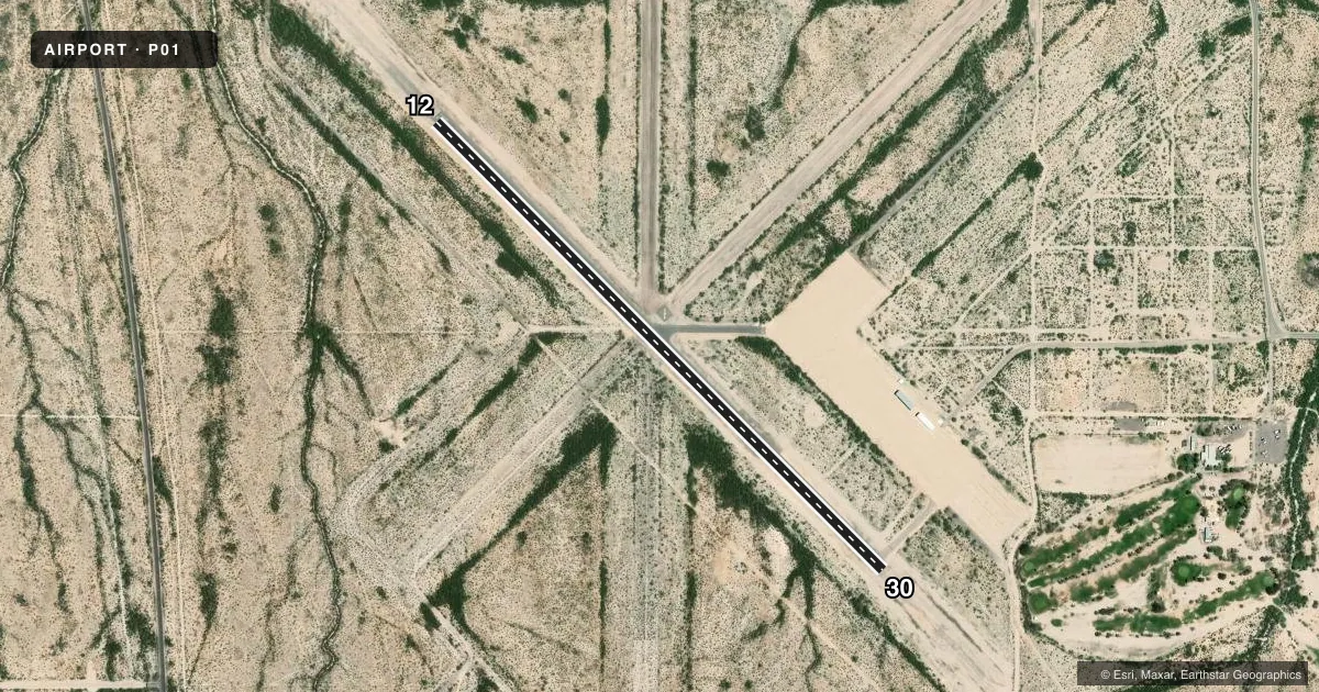
Runways & pattern
Full pagePattern entry · RWY 30
LEFT TRAFFICAirport sketch
Runways drawn to scale from FAA survey coordinates, rendered over satellite imagery. Not for navigation.
Approaches & charts
Services on the field
Fuel grades, oxygen, maintenance, ramp storage and lighting — as declared to the FAA by the airport operator.
Fuel & services
- Fuel
- Not available
Ramp & ground
- Transient storage
- Tie-down
- Landing fee
- No fee published
- Customs
- Not available
- Lighting schedule
- SEE RMK
- Beacon schedule
- SS-SR
- Beacon
- White / Green (civil land)(WG)
- Wind indicator
- Lighted
- Segmented circle
- Yes
Fuel & FBOs
Cheapest 100LL and Jet A on the field and nearby. Always confirm with the FBO before taxi.
Airport notes
Surface conditions, obstructions, local procedures, lighting outages and other notes published with each FAA cycle.
General notes
- MT ALL QUADS. MIL JET TFC & LIVESTOCK ON & INVOF ARPT.
- 6-10 FT RAISED PANELS ACRS RAMP 70 FT IN FRONT OF T-HNGRS; MKD WITH PAINT.
Lighting notes
- PAPI RWY 12 & 30; MIRL RWY 12/30 OPR SS-SR & PRESET LOW INTST; INCR INTST - CTAF.
Runway surface & condition
- 12/30ASPH & GRAVEL STWY 1400 FT NW END; 1065 FT STWY SE END; ASPH BROKEN & BRUSH ON STWYS BYD 200 FT FM THRS. 2 X 2 FT EXPOSED CONC CABLE MRKS BOTH SIDES OF RWY WI 20 FT OF PAVED SFC.
Approach & departure obstructions
- 304 FT DIKE 1340 FT FM THR.
Other notes
- ESTABD PRIOR TO 1959.
- MANAGERJAVIER GARCIA 520-387-6051/520-349-2538.
VFR map & nearby airports
VFR sectional. Tap any ICAO chip to open that airport.
Key facts · P01
Answer card- ICAO
- P01
- Name
- ERIC MARCUS MUNI
- Location
- AJO, ARIZONA
- Elevation
- 1,450 ft MSL
- Traffic pattern altitude
- 2,450 ft MSL (1,000 AGL)
- Control tower
- Non-towered (use CTAF)
- Total runways
- 1
- Longest runway
- 12/30 · 3,800 ft
- Published ILS approaches
- 0
- Published frequencies
- 1
- Magnetic variation
- 9°
- Current flight rules
- VFR
- Current wind
- 240° at 5 kt
- Favored runway now
- RWY 30
Eric Marcus Muni Airport is in Ajo, Arizona. The field elevation is 1,450 ft MSL. It has one runway, 12/30, which is 3,800 ft long with asphalt surface. There is no control tower. CTAF is 122.9. No ILS approaches are published.
Pattern altitude is not published. Use the standard 1,000 ft AGL pattern unless local traffic or the current FAA Chart Supplement says otherwise. The airport sits with mountains in all quadrants, so plan your arrival and departure with terrain in mind. The published remarks also note military jet traffic and livestock in and near the airport area, so keep a sharp lookout on the way in and on the ground.
PAPI is available on both runway ends. Medium intensity runway lights operate from sunset to sunrise. They are preset to low intensity. Increased intensity is available on CTAF. The runway remarks also call out broken asphalt and gravel stopways beyond the thresholds, plus exposed concrete cable markers close to the paved surface. There is also a dike near runway 30. No on-field FBOs are listed, so confirm services with the airport operator or call the field on CTAF before you go.