METAR & TAF E78
E78 does not publish a METAR.
Showing the nearest reporting station: KRYN (RYAN FLD) · 38.7 NM away. Conditions at E78 may differ.
METAR · KRYN
Observed 16:45Z
KRYN 271645Z 29005G13KT 10SM CLR 36/16 A3001
- Wind
- 290° @ 5G13 kt
- Visibility
- 10 SM
- Temp / Dew
- 36°C / 16°C
- Altimeter
- 30.01 inHg
- Clouds
- CLR
- Density alt
- 5,396 ft
- Ceiling
- Unlimited
- Rules
- VFR
Airport info & contacts
Manager on record, flight service, ARTCC, attendance schedule and pattern altitude — published by the FAA and refreshed every 28 days.
Location
- From city
- 2 NM NW
- VFR sectional
- PHOENIX
- ARTCC
- ZAB · ALBUQUERQUE
- NOTAM facility
- PRC (NOTAM-D)
Airport manager
- Name
- NADINE MANUEL
- Phone
- 502-307-3607
- Address
- PO BOX 837, SELLS AZ 85634
Flight service · Hours
- FSS PRC
- PRESCOTT1-800-WX-BRIEF
- Attendance
- Unattended
Frequencies
Tap any row to copy the frequency to your clipboard.
Runways & pattern
Full pagePattern entry · RWY 22
LEFT TRAFFICRunway end performance
| End | TORA | TODA | ASDA | LDA | VGSI | Approach lights | Obstruction |
|---|---|---|---|---|---|---|---|
| 04 | — | — | — | — | — | — | 9', trees, 201' from thr, 0' R of cntrln, slope 0 |
| 22 | — | — | — | — | — | — | 15', trees, 210' from thr, 50' R of cntrln, slope 0 |
Declared distances in feet. TORA = takeoff run available, TODA = takeoff distance, ASDA = accelerate-stop, LDA = landing distance.
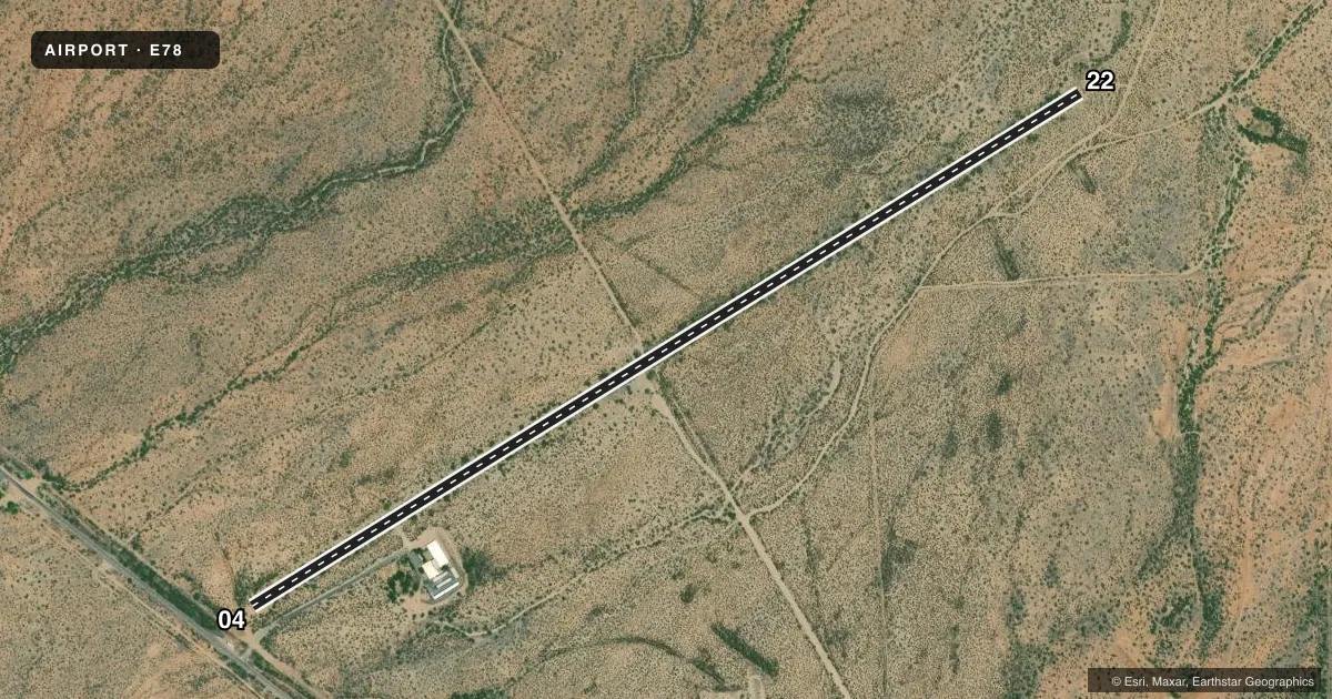
Airport sketch
Runways drawn to scale from FAA survey coordinates, rendered over satellite imagery. Not for navigation.
Approaches & charts
Services on the field
Fuel grades, oxygen, maintenance, ramp storage and lighting — as declared to the FAA by the airport operator.
Fuel & services
- Fuel
- Not available
Ramp & ground
- Transient storage
- Not published
- Landing fee
- No fee published
- Customs
- Not available
- Wind indicator
- No
- Segmented circle
- No
Fuel & FBOs
Cheapest 100LL and Jet A on the field and nearby. Always confirm with the FBO before taxi.
Airport notes
Surface conditions, obstructions, local procedures, lighting outages and other notes published with each FAA cycle.
General notes
- 5 TIEDOWNS IN PRIM SFC.
- LIVESTOCK ON INVOF ARPT.
- FOR CD CTC ALBUQUERQUE ARTCC AT 505-856-4861.
Runway surface & condition
- 04/2215-18 FT TREES & BRUSH IN PRIM SFC FULL LEN BOTH SIDES. 8-15 IN EDGE DROP OFFS & 3 FT DITCHES WI 3 FT OF EDGES. TANK TRUCK PARKED 16 FT FM EDGE NEAR MID POINT.
- 04/22AREAS NRW 20 FT DUE TO BUSHES.
Approach & departure obstructions
- 0410-12 FT TREES & BRUSH 0-200 FT FM THR BOTH SIDES. +3 FT BERM 100 FT FM THR ON CNTRLN ACRS APCH.
- 2212 FT TREE 123 FT FM RWY END 59 FT R; 4 FT FENCE 75 FT FM RWY END 40 FT L & R OF CNTRLN.
- 04FADED.
- 22FADED.
- 046 IN YELLOW CNTRLN STRIPE ONLY.
- 226 IN YELLOW CNTRLN STRIPE ONLY.
Other notes
- ESTABD PRIOR TO 5/15/59.
- 04/22LRG CRACKS, LOOSE AGGREGATE & ISOLATED HOLES.
VFR map & nearby airports
VFR sectional. Tap any ICAO chip to open that airport.
Key facts · E78
Answer card- ICAO
- E78
- Name
- SELLS
- Location
- SELLS, ARIZONA
- Elevation
- 2,409 ft MSL
- Traffic pattern altitude
- 3,409 ft MSL (1,000 AGL)
- Control tower
- Non-towered (use CTAF)
- Total runways
- 1
- Longest runway
- 04/22 · 5,830 ft
- Published ILS approaches
- 0
- Published frequencies
- 1
- Magnetic variation
- 12°
- Current flight rules
- VFR
- Current wind
- 290° at 5 kt
- Favored runway now
- RWY 22
Sells Airport (E78) sits in Sells, Arizona at 2,409 ft MSL. It has one runway, 04/22, which is 5,830 ft long and asphalt. There is no control tower. CTAF is 122.9. No ILS approaches are published here.
The pattern altitude is not published. Use standard 1,000 ft AGL unless the current FAA Chart Supplement says otherwise. That puts the light-aircraft pattern at 3,409 ft MSL based on field elevation. Verify before you fly. The runway is old and the published remarks matter. Expect large cracks, loose aggregate, isolated holes, faded markings and some narrowed areas from brush. The FAA also notes trees and brush near both runway ends. Edge drop-offs, ditches close to the pavement and livestock on or near the airport are also reported. There is even a parked tank truck near the runway edge. Treat this as a rough field and plan your rollout and taxi with care.
No on-field FBOs are listed. Verify fuel and services with the airport operator or the FBO directly by phone before arrival. For a first-time visit, the big items are the runway condition, the obstructions near both ends and the lack of tower or published ILS support. Check your performance, brief the surface and keep a sharp lookout for animals.