METAR & TAF P29
P29 does not publish a METAR.
Showing the nearest reporting station: KFHU (SIERRA VISTA MUNI-LIBBY AAF) · 17.2 NM away. Conditions at P29 may differ.
METAR · KFHU
Observed 16:55Z
KFHU 271655Z AUTO 32007KT 10SM CLR 31/18 A3020 RMK AO2 SLP140 T03120178
- Wind
- 320° @ 7 kt
- Visibility
- 10 SM
- Temp / Dew
- 31°C / 18°C
- Altimeter
- 30.20 inHg
- Clouds
- CLR
- Density alt
- 7,442 ft
- Ceiling
- Unlimited
- Rules
- VFR
Airport info & contacts
Manager on record, flight service, ARTCC, attendance schedule and pattern altitude — published by the FAA and refreshed every 28 days.
Location
- From city
- 3 NM SE
- VFR sectional
- PHOENIX
- ARTCC
- ZAB · ALBUQUERQUE
- NOTAM facility
- PRC (NOTAM-D)
Airport manager
- Name
- JESSE GRASSMAN
- Phone
- 520-457-3415
- Address
- 611 E ALLEN STREET, PO BOX 339, TOMBSTONE AZ 85638
Flight service · Hours
- FSS PRC
- PRESCOTT1-800-WX-BRIEF
- Attendance
- Unattended
Frequencies
Tap any row to copy the frequency to your clipboard.
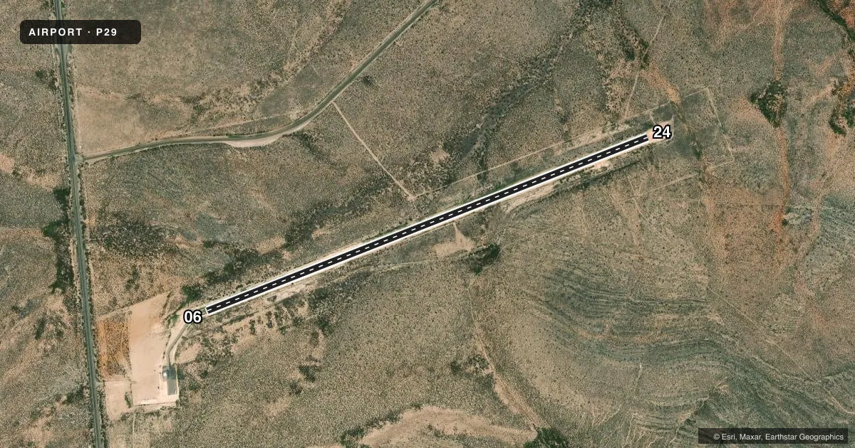
Runways & pattern
Full pagePattern entry · RWY 24
LEFT TRAFFICRunway end performance
| End | TORA | TODA | ASDA | LDA | VGSI | Approach lights | Obstruction |
|---|---|---|---|---|---|---|---|
| 06 | — | — | — | — | — | — | 4', brush, 214' from thr, 90' R of cntrln, slope 3 |
| 24 | — | — | — | — | — | — | 8', brush, 250' from thr, 65' R of cntrln, slope 6 |
Declared distances in feet. TORA = takeoff run available, TODA = takeoff distance, ASDA = accelerate-stop, LDA = landing distance.
Airport sketch
Runways drawn to scale from FAA survey coordinates, rendered over satellite imagery. Not for navigation.
Approaches & charts
Services on the field
Fuel grades, oxygen, maintenance, ramp storage and lighting — as declared to the FAA by the airport operator.
Fuel & services
- Fuel
- Not available
Ramp & ground
- Transient storage
- Tie-down
- Landing fee
- No fee published
- Customs
- Not available
- Wind indicator
- Yes
- Segmented circle
- No
Fuel & FBOs
Cheapest 100LL and Jet A on the field and nearby. Always confirm with the FBO before taxi.
Airport notes
Surface conditions, obstructions, local procedures, lighting outages and other notes published with each FAA cycle.
General notes
- 15 FT TREES & BUSHES WI PRIM SFC.
- FOR CD CTC ALBUQUERQUE ARTCC AT 505-856-4861.
- GATE CODE 3124.
Runway surface & condition
- 06/242-6 FT BRUSH BOTH SIDES.
Approach & departure obstructions
- 062-4 FT BRUSH 0-200 FT FM THR 55-125 FT L OF CNTRLN; 2-3 FT BRUSH 60-125 FT R OF CNTRLN.
- 24DITCH 220 FT E OF RWY PERPENDICULAR TO CNTRLN; 10 FT DITCH 0-200 FT FM THR 65 FT L OF CNTRLN; 4-8 FT BRUSH 0-200 FT FM THR 60-125 FT L OF CNTRLN; 2-3 FT BRUSH 0-200 FT FM THR 60 FT R OF CNTRLN.
Other notes
- ESTABD PRIOR TO 15 MAY 1959.
- 1AVBLTY - AMGR.
VFR map & nearby airports
VFR sectional. Tap any ICAO chip to open that airport.
Key facts · P29
Answer card- ICAO
- P29
- Name
- TOMBSTONE MUNI
- Location
- TOMBSTONE, ARIZONA
- Elevation
- 4,733.2 ft MSL
- Traffic pattern altitude
- 5,733.2 ft MSL (1,000 AGL)
- Control tower
- Non-towered (use CTAF)
- Total runways
- 1
- Longest runway
- 06/24 · 4,430 ft
- Published ILS approaches
- 0
- Published frequencies
- 1
- Magnetic variation
- 10°
- Current flight rules
- VFR
- Current wind
- 320° at 7 kt
- Favored runway now
- RWY 24
Tombstone Muni is in Tombstone, Arizona. The field elevation is 4,733.2 ft MSL. It has one runway, 06/24, which is 4,430 ft long and asphalt. There is no control tower. CTAF is 122.9. No ILS approaches are published here.
The published pattern altitude is not listed, so use the standard 1,000 ft AGL pattern for light piston aircraft unless the current Chart Supplement says otherwise. That puts the normal pattern reference at about 5,733 ft MSL. The airport sits in a high-desert environment, so performance will be different than at low-elevation fields. Plan for density altitude, especially on warm days.
Published remarks show brush and trees near the runway environment. There is a ditch east of the runway near the 24 threshold area. There is also brush close to both sides of the runway and within the primary surface. For clearance delivery, contact Albuquerque ARTCC at 505-856-4861. Service availability is airport manager. No on-field FBOs are listed, so verify fuel and other services with the airport operator before you go. The airport gate code is 3124.