METAR & TAF P03
P03 does not publish a METAR.
Showing the nearest reporting station: KDUG (BISBEE DOUGLAS INTL) · 7.3 NM away. Conditions at P03 may differ.
METAR · KDUG
Observed 17:56Z
KDUG 271756Z AUTO 35005KT 10SM CLR 34/17 A3013 RMK AO2 SLP113 T03390167 10339 20217 58001 TSNO
- Wind
- 350° @ 5 kt
- Visibility
- 10 SM
- Temp / Dew
- 34°C / 17°C
- Altimeter
- 30.13 inHg
- Clouds
- CLR
- Density alt
- 7,161 ft
- Ceiling
- Unlimited
- Rules
- VFR
Airport info & contacts
Manager on record, flight service, ARTCC, attendance schedule and pattern altitude — published by the FAA and refreshed every 28 days.
Location
- From city
- 7 NM W
- VFR sectional
- PHOENIX
- ARTCC
- ZAB · ALBUQUERQUE
- NOTAM facility
- PRC (NOTAM-D)
Airport manager
- Name
- BELINDA BURNETT
- Phone
- 520-417-4114
- Address
- COCHISE COMMUNITY COLLEGE, 4190 W. HIGHWAY 80, DOUGLAS AZ 85607-6190
Flight service · Hours
- FSS PRC
- PRESCOTT1-800-WX-BRIEF
- Attendance
- MON-FRI · 0630-1630
Frequencies
Tap any row to copy the frequency to your clipboard.
Runways & pattern
Full pagePattern entry · RWY 05
LEFT TRAFFICRunway end performance
| End | TORA | TODA | ASDA | LDA | VGSI | Approach lights | Obstruction |
|---|---|---|---|---|---|---|---|
| 05 | 5,441' | 5,551' | 5,441' | 5,441' | PAPI 4-box left(3°) | — | 15', road, 366' from thr, 140' R of cntrln, slope 11 |
| 23 | 5,551' | 5,551' | — | 5,103' | PAPI 4-box left(3°) | — | 15', road, 201' from thr, 60' R of cntrln, slope 0 |
Declared distances in feet. TORA = takeoff run available, TODA = takeoff distance, ASDA = accelerate-stop, LDA = landing distance.
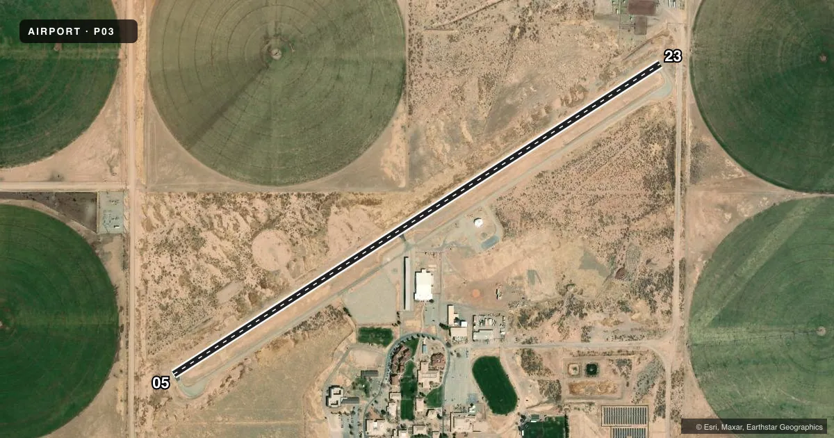
Airport sketch
Runways drawn to scale from FAA survey coordinates, rendered over satellite imagery. Not for navigation.
Approaches & charts
Services on the field
Fuel grades, oxygen, maintenance, ramp storage and lighting — as declared to the FAA by the airport operator.
Fuel & services
- Fuel
- Not available
- Other services
- INSTR
Ramp & ground
- Transient storage
- Tie-down
- Landing fee
- No fee published
- Lighting schedule
- SEE RMK
- Beacon schedule
- SS-SR
- Beacon
- White / Green (civil land)(WG)
- Wind indicator
- Lighted
- Segmented circle
- Yes
Fuel & FBOs
Cheapest 100LL and Jet A on the field and nearby. Always confirm with the FBO before taxi.
Airport notes
Surface conditions, obstructions, local procedures, lighting outages and other notes published with each FAA cycle.
General notes
- UAS OPS & WILDLIFE ON OR INVOF ARPT.
- SCTY - 520-417-4022.
- FOR CD CTC ALBUQUERQUE ARTCC AT 505-856-4861.
Lighting notes
- ACTVT MIRL RWY 05/23 - CTAF.
Approach & departure obstructions
- 052-4 FT WEEDS 100-200 FT FM THR ACRS APCH.
- 2315 FT ROAD 70 FT FM THR 250 FT L OF CNTRLN; 4 FT FENCE 55 FT FM THR 50-250 FT L OF CNTRLN; +2-3 FT BRUSH 20-200 FT FM THR ACRS APCH.
- 23APCH SLOPE 0:1 TO DTHR; 5 FT BRUSH AT DTHR 100 FT L OF CNTRLN.
Other notes
- E111 PROVIDED VFR ONLY.
VFR map & nearby airports
VFR sectional. Tap any ICAO chip to open that airport.
Key facts · P03
Answer card- ICAO
- P03
- Name
- COCHISE COLLEGE
- Location
- DOUGLAS, ARIZONA
- Elevation
- 4,146 ft MSL
- Traffic pattern altitude
- 5,146 ft MSL (1,000 AGL)
- Control tower
- Non-towered (use CTAF)
- Total runways
- 1
- Longest runway
- 05/23 · 5,551 ft
- Published ILS approaches
- 0
- Published frequencies
- 2
- Magnetic variation
- 12°
- Current flight rules
- VFR
- Current wind
- 350° at 5 kt
- Favored runway now
- RWY 05
Cochise College Airport (P03) sits in Douglas, Arizona. The field elevation is 4,146 ft MSL. It has one runway. Runway 05/23 is 5,551 ft long with asphalt pavement. The airport is not towered. CTAF and UNICOM are both 122.8. No ILS approaches are published here.
The pattern altitude is not published. Use the standard 1,000 ft AGL pattern unless local procedures or the current FAA Chart Supplement say otherwise. That puts the light piston pattern at about 5,146 ft MSL. Runway lights on 05/23 are medium intensity. They are activated by CTAF.
This is a VFR-only field per the published remarks. The remarks also note wildlife and unmanned aircraft activity in the area. There are obstructions near the approach to both runway ends. On 05, weeds are reported near the threshold. On 23, there is a road, a fence and brush near the approach path. The runway slope to the displaced threshold on 23 is steep enough to matter on short final. Plan a careful stabilized approach. Check the current FAA Chart Supplement for any updated restrictions before flying in.
No on-field FBOs are listed. Contact the airport operator directly or call the field on CTAF for current services before arrival.