METAR & TAF KDGL
KDGL does not publish a METAR.
Showing the nearest reporting station: KDUG (BISBEE DOUGLAS INTL) · 9.1 NM away. Conditions at KDGL may differ.
METAR · KDUG
Observed 17:56Z
KDUG 271756Z AUTO 35005KT 10SM CLR 34/17 A3013 RMK AO2 SLP113 T03390167 10339 20217 58001 TSNO
- Wind
- 350° @ 5 kt
- Visibility
- 10 SM
- Temp / Dew
- 34°C / 17°C
- Altimeter
- 30.13 inHg
- Clouds
- CLR
- Density alt
- 7,194 ft
- Ceiling
- Unlimited
- Rules
- VFR
Airport info & contacts
Manager on record, flight service, ARTCC, attendance schedule and pattern altitude — published by the FAA and refreshed every 28 days.
Location
- From city
- 2 NM E
- VFR sectional
- PHOENIX
- ARTCC
- ZAB · ALBUQUERQUE
- NOTAM facility
- PRC (NOTAM-D)
Airport manager
- Name
- MAX TAPIA
- Phone
- 520-368-6015
- Address
- 425 E. 10TH STREET, DOUGLAS AZ 85607
Flight service · Hours
- FSS PRC
- PRESCOTT1-800-WX-BRIEF
- Attendance
- MON-FRI · 0600-1400
Frequencies
Tap any row to copy the frequency to your clipboard.
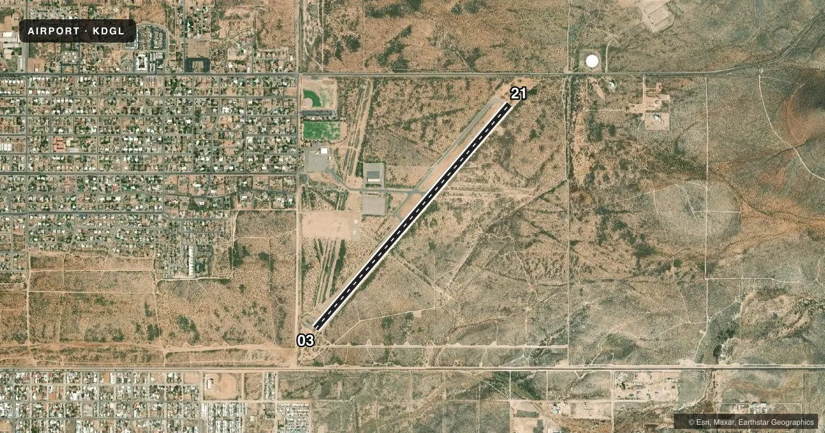
Runways & pattern
Full pagePattern entry · RWY 03
RIGHT TRAFFICRunway end performance
| End | TORA | TODA | ASDA | LDA | VGSI | Approach lights | Obstruction |
|---|---|---|---|---|---|---|---|
| 03 | — | — | — | — | PAPI 4-box left(4°) | — | 7', brush, 260' from thr, 10' R of cntrln, slope 8 |
| 21 | — | — | — | — | PAPI 4-box left(4°) | — | 8', brush, 201' from thr, 45' R of cntrln, slope 0 |
Declared distances in feet. TORA = takeoff run available, TODA = takeoff distance, ASDA = accelerate-stop, LDA = landing distance.
Airport sketch
Runways drawn to scale from FAA survey coordinates, rendered over satellite imagery. Not for navigation.
Approaches & charts
Services on the field
Fuel grades, oxygen, maintenance, ramp storage and lighting — as declared to the FAA by the airport operator.
Fuel & services
- Fuel
- 100LLA
- Other services
- AMB
Ramp & ground
- Transient storage
- Tie-down
- Hangar
- Landing fee
- No fee published
- Customs
- Available
- Lighting schedule
- SEE RMK
- Beacon schedule
- SS-SR
- Beacon
- White / Green (civil land)(WG)
- Wind indicator
- Lighted
- Segmented circle
- Yes
Fuel & FBOs
Cheapest 100LL and Jet A on the field and nearby. Always confirm with the FBO before taxi.
Airport notes
Surface conditions, obstructions, local procedures, lighting outages and other notes published with each FAA cycle.
General notes
- MTS 1.5 MI E.
- FLIGHT NOTIFICATION SVC AVBL.
- PSNL & ATVS UNRSTRD INVOF OPS AREAS.
Lighting notes
- DUSK-DAWN. PAPI RWY 03 & 21 OTS INDFLY.
Fuel notes
- 100LLH24 WITH CREDIT CARD.
Runway surface & condition
- 03/214-6 FT BRUSH IN PRIM SFC 30 FT FM CNTRLN.
- 18/36CLSD INDEFLY. 2 FT BUMP XG TWY TO RWY 03/21; +3 FT BUMP 300 FT FM RWY 18 THR. BRUSH BOTH SIDES 70 FT FM CNTRLN FULL LEN.
Approach & departure obstructions
- 033-8 FT BRUSH 0-200 FT FM THR 45-125 FT L & R OF CNTRLN.
- 212-6 FT BRUSH 0-200 FT FM THR 30-125 FT L & R OF CNTRLN.
- 03PAPI OTS INDEFLY.
- 21PAPI OTS INDEFLY.
- 2150 FT LGTD TWR 1350 FT FM THR 550 FT L.
Other notes
- ESTABD PRIOR TO 5/15/59.
- 1AFT HR - AMGR.
- MANAGERALEXANDRO TERAN - 520--368-6015.
- 03/211-6 IN CRACKS ACRS RWY.
- 18/36+4 FT BRUSH, ROCKS & UNEVEN SFC 3/4 OF RWY LEN.
VFR map & nearby airports
VFR sectional. Tap any ICAO chip to open that airport.
Key facts · KDGL
Answer card- ICAO
- KDGL
- Name
- DOUGLAS MUNI
- Location
- DOUGLAS, ARIZONA
- Elevation
- 4,173 ft MSL
- Traffic pattern altitude
- 5,173 ft MSL (1,000 AGL)
- Control tower
- Non-towered (use CTAF)
- Total runways
- 1
- Longest runway
- 03/21 · 5,760 ft
- Published ILS approaches
- 0
- Published frequencies
- 2
- Magnetic variation
- 12°
- Current flight rules
- VFR
- Current wind
- 350° at 5 kt
- Favored runway now
- RWY 03
Douglas Muni sits in Douglas, Arizona. Field elevation is 4,173 ft MSL. The airport has one runway, 03/21, at 5,760 ft. There is no control tower. CTAF and UNICOM are both 122.8. No ILS approaches are published. Pattern altitude is not published, so check the current Chart Supplement before you go. For light piston work, pilots often use the standard 1,000 ft AGL pattern unless local guidance says otherwise.
Douglas Municipal Airport is the on-field FBO. It carries 100LL and Jet A. 100LL is available 24 hours with credit card. Flight notification service is available. After hours, contact the airport manager. The airport lighting is available from dusk to dawn. The PAPI for both runway ends is out of service indefinitely, so plan your visual glide path carefully.
This is a high-elevation field with mountains about 1.5 miles east of the airport. That makes density altitude and terrain awareness part of the briefing. Published remarks also note brush near both runway thresholds and along the primary surface. Use extra caution on rollout, taxi and takeoff planning. Check the current Chart Supplement for any noise or operational updates before flying in.