METAR & TAF KDNA
Current METAR
Observed 19:55Z
KDNA 271955Z AUTO 25008KT 10SM CLR 40/10 A3001 RMK AO2
- Wind
- 250° @ 8 kt
- Visibility
- 10 SM
- Temp / Dew
- 40°C / 10°C
- Altimeter
- 30.01 inHg
- Clouds
- CLR
- Density alt
- 7,988 ft
- Ceiling
- Unlimited
- Rules
- VFR
Airport info & contacts
Manager on record, flight service, ARTCC, attendance schedule and pattern altitude — published by the FAA and refreshed every 28 days.
Location
- From city
- 4 NM NW
- VFR sectional
- EL PASO
- ARTCC
- ZAB · ALBUQUERQUE
- NOTAM facility
- DNA (NOTAM-D)
Airport manager
- Name
- JODY WOUNG
- Phone
- 575-644-5398
- Address
- 8014 AIRPORT RD, SANTA TERESA NM 88008-9719
Flight service · Hours
- FSS ABQ
- ALBUQUERQUE1-800-WX-BRIEF
- Attendance
- 0700-1800
Frequencies
Tap any row to copy the frequency to your clipboard.
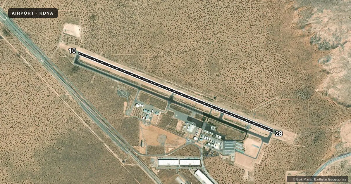
Runways & pattern
Full pagePattern entry · RWY 28
RIGHT TRAFFICRunway end performance
| End | TORA | TODA | ASDA | LDA | VGSI | Approach lights | Obstruction |
|---|---|---|---|---|---|---|---|
| 10 | — | — | — | — | PAPI 4-box left(3°) | — | — |
| 28 | — | — | — | — | PAPI 4-box left(3°) | — | — |
Declared distances in feet. TORA = takeoff run available, TODA = takeoff distance, ASDA = accelerate-stop, LDA = landing distance.
Airport sketch
Runways drawn to scale from FAA survey coordinates, rendered over satellite imagery. Not for navigation.
Approaches & charts
Services on the field
Fuel grades, oxygen, maintenance, ramp storage and lighting — as declared to the FAA by the airport operator.
Fuel & services
- Fuel
- 100LLA1+
- Oxygen (bottled)
- HIGH/LOW
- Oxygen (bulk)
- HIGH/LOW
- Airframe repair
- Major
- Power plant repair
- Major
- Other services
- INSTR,PAJA,RNTL
Ramp & ground
- Transient storage
- Tie-down
- Hangar
- Customs
- Not available
- Lighting schedule
- SEE RMK
- Beacon schedule
- SS-SR
- Beacon
- White / Green (civil land)(WG)
- Wind indicator
- Lighted
- Segmented circle
- Yes
Fuel & FBOs
Cheapest 100LL and Jet A on the field and nearby. Always confirm with the FBO before taxi.
Airport notes
Surface conditions, obstructions, local procedures, lighting outages and other notes published with each FAA cycle.
General notes
- FOR CD CTC EL PASO APCH ON FREQ, IF UNA CTC EL PASO APCH AT 915-774-9447.
Lighting notes
- ACTVT REIL RWY 10 & 28; MIRL RWY 10/28 - CTAF. PAPI RWY 10 & 28 OPR CONSLY.
Fuel notes
- 100LL100LL AVBL H24 SELF SVC VIA CREDIT CARD.
- A1+JET A1+ ALSO AVBL AFT 1800 SUBJ CALL OUT FEE - 844-589-4586.
Other notes
- PRVDD COMPATIBLE TFC PATS ARE ESTABD WITH NM05 ARPT.
- AVBL WKDAYS AT HNGR 14.
- AVBL WKDAYS AT HNGR 14.
- CUST AOE HRS 0800-2200 - 915-730-7402.
- SHADE HNGRS.
- AUTOMATED UNICOM - 3 CLICKS.
- MANAGEREMERGENCY PHONE: 575-644-5398
VFR map & nearby airports
VFR sectional. Tap any ICAO chip to open that airport.
Key facts · KDNA
Answer card- ICAO
- KDNA
- Name
- DONA ANA COUNTY INTL JETPORT
- Location
- SANTA TERESA, NEW MEXICO
- Elevation
- 4,112.8 ft MSL
- Traffic pattern altitude
- 5,112.8 ft MSL (1,000 AGL)
- Control tower
- Non-towered (use CTAF)
- Total runways
- 1
- Longest runway
- 10/28 · 9,550 ft
- Published ILS approaches
- 0
- Published frequencies
- 8
- Magnetic variation
- 11°
- Current flight rules
- VFR
- Current wind
- 250° at 8 kt
- Favored runway now
- RWY 28
Dona Ana County Intl Jetport is in Santa Teresa, New Mexico. Field elevation is 4,112.8 ft MSL. The airport has one runway, 10/28, which is 9,550 ft long. There is no control tower. CTAF and UNICOM are both 122.725. Approach and departure are on 119.15 with El Paso. No ILS approaches are published here.
Pattern altitude is not published. Use the standard 1,000 ft AGL pattern for light piston traffic unless the current Chart Supplement or local procedures say otherwise. The field sits in a high desert environment near the border area, so density altitude will matter on warm days. Plan performance with that in mind.
Francis Aviation is the on-field FBO. It carries AVGAS 100LL, Jet A and Jet A Prist. 100LL is available 24 hours daily by self-service credit card. Jet A1+ is also available after 1800 with a call-out fee. Published remarks also note shade hangars, REIL on runways 10 and 28, medium intensity runway lights on 10 and 28 controlled by CTAF and PAPI on both ends that operate continuously. Customer area of operations hours are 0800 to 2200. For clearance delivery, contact Albuquerque ARTCC. First-time arrivals should brief the lighting setup. They should also brief the high elevation and the lack of tower service before coming in.