METAR & TAF E02
E02 does not publish a METAR.
Showing the nearest reporting station: KALM (ALAMOGORDO-WHITE SANDS RGNL) · 19.7 NM away. Conditions at E02 may differ.
METAR · KALM
Observed 20:55Z
KALM 272055Z AUTO 00000KT 9SM CLR 39/09 A2998 RMK AO2 LTG DSNT NE AND E
- Wind
- 000° @ 0 kt
- Visibility
- 9 SM
- Temp / Dew
- 39°C / 9°C
- Altimeter
- 29.98 inHg
- Clouds
- CLR
- Density alt
- 11,440 ft
- Ceiling
- Unlimited
- Rules
- VFR
Airport info & contacts
Manager on record, flight service, ARTCC, attendance schedule and pattern altitude — published by the FAA and refreshed every 28 days.
Location
- From city
- 21 NM SE
- VFR sectional
- ALBUQUERQUE
- ARTCC
- ZAB · ALBUQUERQUE
- NOTAM facility
- ABQ (NOTAM-D)
Airport manager
- Name
- DON WIKLAND
- Phone
- 915-497-4283
- Address
- JOE LANGFORD, 66 MERLIN RD., TIMBERON NM 88350
Flight service · Hours
- FSS ABQ
- ALBUQUERQUE1-800-WX-BRIEF
- Attendance
- Unattended
Frequencies
Tap any row to copy the frequency to your clipboard.
Runways & pattern
Full pagePattern entry · RWY 13
RIGHT TRAFFICRunway end performance
| End | TORA | TODA | ASDA | LDA | VGSI | Approach lights | Obstruction |
|---|---|---|---|---|---|---|---|
| 13 | — | — | — | — | — | — | 55', trees, 265' from thr, 25' R of cntrln, slope 1 |
| 31 | — | — | — | — | — | — | 67', trees, 270' from thr, 80' R of cntrln, slope 1 |
Declared distances in feet. TORA = takeoff run available, TODA = takeoff distance, ASDA = accelerate-stop, LDA = landing distance.
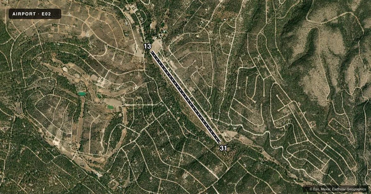
Airport sketch
Runways drawn to scale from FAA survey coordinates, rendered over satellite imagery. Not for navigation.
Approaches & charts
Services on the field
Fuel grades, oxygen, maintenance, ramp storage and lighting — as declared to the FAA by the airport operator.
Fuel & services
- Fuel
- Not available
Ramp & ground
- Transient storage
- Not published
- Landing fee
- No fee published
- Wind indicator
- Yes
- Segmented circle
- No
Fuel & FBOs
Cheapest 100LL and Jet A on the field and nearby. Always confirm with the FBO before taxi.
Airport notes
Surface conditions, obstructions, local procedures, lighting outages and other notes published with each FAA cycle.
General notes
- DEER & ELK ON RWY SPCLY DUSK.
- FOR CD CTC ALBUQUERQUE ARTCC AT 505-856-4861.
Runway surface & condition
- 13/31DEP RWY 13; ARR RWY 31. FIRE STATION 500 FT NW. 2 DEG DOWNHILL SLOPE TO SE.
Approach & departure obstructions
- 1340-60 FT TREES 0-200 FT FM THR 60-125 FT R. 4-8 FT TREES 140-200 FT FM THR 0-125 FT L OF CNTRLN.
- 3110-12 FT TREES ACRS THR 0-200 FT.
- 13HELI NEAR THR.
Other notes
- VFR USE ONLY.
- 13/31CHIP SEAL.
VFR map & nearby airports
VFR sectional. Tap any ICAO chip to open that airport.
Key facts · E02
Answer card- ICAO
- E02
- Name
- TIMBERON
- Location
- ALAMOGORDO, NEW MEXICO
- Elevation
- 6,963 ft MSL
- Traffic pattern altitude
- 7,963 ft MSL (1,000 AGL)
- Control tower
- Non-towered (use CTAF)
- Total runways
- 1
- Longest runway
- 13/31 · 4,860 ft
- Published ILS approaches
- 0
- Published frequencies
- 1
- Magnetic variation
- 11°
- Current flight rules
- VFR
- Current wind
- 000° at 0 kt
- Favored runway now
- –
Timberon Airport sits near Alamogordo, New Mexico. The field elevation is 6,963 ft MSL. It has one runway. Runway 13/31 is 4,860 ft long with an asphalt surface, though the published remarks also note chip seal. There is no control tower. CTAF is 122.9.
No ILS approaches are published here. The airport is for VFR use only. Pattern altitude is not published, so verify the current traffic pattern altitude before you go. For a light piston, pilots often plan around the standard 1,000 ft AGL pattern. That is not a published value for this field.
The published remarks matter here. Trees sit near both runway ends. A helicopter is near the threshold of runway 13. Runway 13 has a downhill slope toward the southeast. Runway 31 has trees across the threshold. Deer and elk are reported on the runway, especially at dusk. For clearance delivery, contact Albuquerque ARTCC at 505-856-4861. No on-field FBOs are listed, so verify services and fuel availability with the airport operator or the FBO directly by phone before arrival. At this elevation, takeoff and climb performance deserve a close look. That is especially true on warm days.