METAR & TAF KSRR
Current METAR
Observed 20:55Z
KSRR 272055Z AUTO 05013G18KT 10SM CLR 33/11 A3023 RMK AO2 T03320106 58013 $
- Wind
- 050° @ 13G18 kt
- Visibility
- 10 SM
- Temp / Dew
- 33°C / 11°C
- Altimeter
- 30.23 inHg
- Clouds
- CLR
- Density alt
- 10,225 ft
- Ceiling
- Unlimited
- Rules
- VFR
Airport info & contacts
Manager on record, flight service, ARTCC, attendance schedule and pattern altitude — published by the FAA and refreshed every 28 days.
Location
- From city
- 15 NM NE
- VFR sectional
- ALBUQUERQUE
- ARTCC
- ZAB · ALBUQUERQUE
- NOTAM facility
- SRR (NOTAM-D)
Airport manager
- Name
- LEE BAKER
- Phone
- 575-336-8111
- Address
- 313 CREE MEADOWS DR, RUIDOSO NM 88345
Flight service · Hours
- FSS ABQ
- ALBUQUERQUE1-800-WX-BRIEF
- Attendance
- MAY - OCT · 0700-1900
- NOV - APR · 0700-1800
Frequencies
Tap any row to copy the frequency to your clipboard.
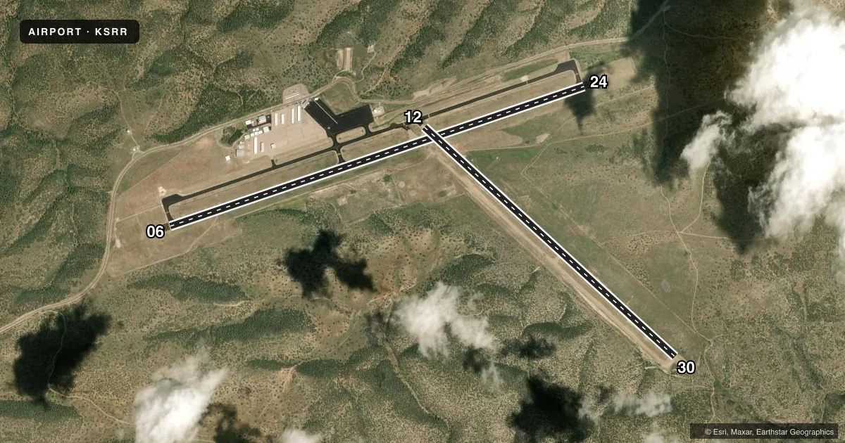
Runways & pattern
Full pagePattern entry · RWY 06
LEFT TRAFFIC| Runway | Heading (°M) | Length | Surface | Traffic |
|---|---|---|---|---|
| 06/24Favored | 61° / 241° | 8,120 ft | ASPH | Standard L |
| 12/30 | 122° / 302° | 6,309 ft | ASPH | Standard L |
Runway end performance
| End | TORA | TODA | ASDA | LDA | VGSI | Approach lights | Obstruction |
|---|---|---|---|---|---|---|---|
| 06 | 8,120' | 8,120' | 8,120' | 8,120' | NSTD(3°) | — | — |
| 24 | 8,120' | 8,120' | 8,120' | 8,120' | — | — | — |
| 12 | 6,309' | 6,309' | 6,309' | 6,309' | PAPI 2-box left(3°) | — | — |
| 30 | 6,309' | 6,309' | 6,309' | 6,309' | PAPI 2-box left(3°) | — | — |
Declared distances in feet. TORA = takeoff run available, TODA = takeoff distance, ASDA = accelerate-stop, LDA = landing distance.
Airport sketch
Runways drawn to scale from FAA survey coordinates, rendered over satellite imagery. Not for navigation.
Approaches & charts
ILS · 1
Services on the field
Fuel grades, oxygen, maintenance, ramp storage and lighting — as declared to the FAA by the airport operator.
Fuel & services
- Fuel
- 100LLA1+
- Other services
- AFRT,AMB,INSTR
Ramp & ground
- Transient storage
- Tie-down
- Hangar
- Lighting schedule
- SEE RMK
- Beacon schedule
- SS-SR
- Beacon
- White / Green (civil land)(WG)
- Wind indicator
- Lighted
- Segmented circle
- Yes
Fuel & FBOs
Cheapest 100LL and Jet A on the field and nearby. Always confirm with the FBO before taxi.
Airport notes
Surface conditions, obstructions, local procedures, lighting outages and other notes published with each FAA cycle.
General notes
- SFC COND UNMNT WHEN UNATNDD.
- FOR CD IF UNA TO CTC ON FSS FREQ, CTC ALBUQUERQUE ARTCC AT 505-856-4561.
Lighting notes
- ACTVT REIL RWY 12 & 30; PAPI RWY 12 & 30; MIRL RWY 06/24 & 12/30 - CTAF.
Fuel notes
- 100LLAFT HR - 575-973-0074.
Runway surface & condition
- 06/24PCR VALUE: 690/F/B/X/T
- 12/30PCR VALUE: 240/F/C/X/T
- 12/30RWY 12/30 NOT AVBL FOR PART 121/PART 380 OPS WITH SKED PAX CARRYING OPS MORE THAN 9 PAX SEATS AND NON-SKED PAX CARRYING OPS MORE THAN 30 PAX SEATS.
Approach & departure obstructions
- 06UNUSBL; OTS UFN.
Other notes
- ACR OPS MORE THAN 30 PAX SEATS 24 HR PPR - AMGR.
VFR map & nearby airports
VFR sectional. Tap any ICAO chip to open that airport.
Key facts · KSRR
Answer card- ICAO
- KSRR
- Name
- SIERRA BLANCA RGNL
- Location
- RUIDOSO, NEW MEXICO
- Elevation
- 6,813.8 ft MSL
- Traffic pattern altitude
- 7,813.8 ft MSL (1,000 AGL)
- Control tower
- Non-towered (use CTAF)
- Total runways
- 2
- Longest runway
- 06/24 · 8,120 ft
- Published ILS approaches
- 1
- Published frequencies
- 2
- Magnetic variation
- 10°
- Current flight rules
- VFR
- Current wind
- 050° at 13 kt
- Favored runway now
- RWY 06
Sierra Blanca Regional Airport sits in Ruidoso, New Mexico. Field elevation is 6,813.8 ft MSL, so performance planning matters here. The airport has two asphalt runways. The longest is runway 06/24 at 8,120 ft. Runway 12/30 is 6,309 ft. There is no control tower. CTAF and UNICOM are both 122.8.
The field has one ILS approach on runway 24. Published remarks also note visual approach slope indicators on runway 06. Precision approach path indicators are available on runways 12 and 30. Runway end identifier lights are on 12 and 30. Medium intensity runway lighting is available on both runways and is controlled by the CTAF.
Pattern altitude is not published. Use the standard 1,000 ft AGL for light piston traffic unless the current FAA Chart Supplement says otherwise. Sierra Blanca Regional Airport is the on-field FBO. It carries 100LL and Jet A Prist. Call the FBO directly at (575) 336-8111 for current service details. After-hours fuel service is also listed in the remarks.
This is a high-elevation field in mountain country. Expect density altitude to be a real factor, especially on warm days. The remarks also call out operating limits for larger passenger-carrying aircraft. Check the current FAA Chart Supplement before you go. Surface condition is unmonitored when the airport is unattended.