METAR & TAF F37
F37 does not publish a METAR.
Showing the nearest reporting station: KSRR (SIERRA BLANCA RGNL) · 21.5 NM away. Conditions at F37 may differ.
METAR · KSRR
Observed 13:35Z
KSRR 271335Z AUTO 30005KT 9SM CLR 24/13 A3028 RMK AO2 T02380128 $
- Wind
- 300° @ 5 kt
- Visibility
- 9 SM
- Temp / Dew
- 24°C / 13°C
- Altimeter
- 30.28 inHg
- Clouds
- CLR
- Density alt
- 7,296 ft
- Ceiling
- Unlimited
- Rules
- VFR
Airport info & contacts
Manager on record, flight service, ARTCC, attendance schedule and pattern altitude — published by the FAA and refreshed every 28 days.
Location
- From city
- 1 NM NW
- VFR sectional
- ALBUQUERQUE
- ARTCC
- ZAB · ALBUQUERQUE
- NOTAM facility
- ABQ (NOTAM-D)
Airport manager
- Name
- BILL HAYES
- Phone
- 575-648-5380
- Address
- PO BOX 597, CARRIZOZO NM 88301
Flight service · Hours
- FSS ABQ
- ALBUQUERQUE1-800-WX-BRIEF
- Attendance
- ALL
Frequencies
Tap any row to copy the frequency to your clipboard.
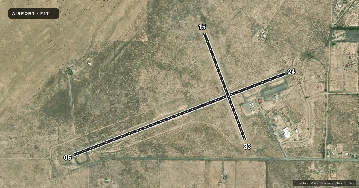
Runways & pattern
Full pagePattern entry · RWY 33
LEFT TRAFFIC| Runway | Heading (°M) | Length | Surface | Traffic |
|---|---|---|---|---|
| 06/24 | 58° / 238° | 4,944 ft | ASPH | Standard L |
| 15/33Favored | 149° / 329° | 2,500 ft | DIRT | Standard L |
Runway end performance
| End | TORA | TODA | ASDA | LDA | VGSI | Approach lights | Obstruction |
|---|---|---|---|---|---|---|---|
| 06 | — | — | — | — | PAPI 2-box left(3°) | — | — |
| 24 | — | — | — | — | PAPI 2-box left(3°) | — | — |
| 15 | — | — | — | — | — | — | 4', brush, 20' from thr, 0' R of cntrln, slope 5 |
Declared distances in feet. TORA = takeoff run available, TODA = takeoff distance, ASDA = accelerate-stop, LDA = landing distance.
Airport sketch
Runways drawn to scale from FAA survey coordinates, rendered over satellite imagery. Not for navigation.
Approaches & charts
Services on the field
Fuel grades, oxygen, maintenance, ramp storage and lighting — as declared to the FAA by the airport operator.
Fuel & services
- Fuel
- 100LL
- Airframe repair
- Minor
- Power plant repair
- Minor
Ramp & ground
- Transient storage
- Tie-down
- Hangar
- Landing fee
- No fee published
- Customs
- Not available
- Lighting schedule
- SEE RMK
- Beacon schedule
- SS-SR
- Beacon
- White / Green (civil land)(WG)
- Wind indicator
- Lighted
- Segmented circle
- Yes
Fuel & FBOs
Cheapest 100LL and Jet A on the field and nearby. Always confirm with the FBO before taxi.
Airport notes
Surface conditions, obstructions, local procedures, lighting outages and other notes published with each FAA cycle.
General notes
- WILDLIFE ON & INVOF AIRPORT.
- FOR CD CTC ALBUQUERQUE ARTCC AT 505-856-4861.
Lighting notes
- ACTVT REIL RWY 06 & 24; PAPI RWY 06 & 24; MIRL RWY 06/24 - CTAF.
Runway surface & condition
- 15/33BDRY MKRS 72 FT L & R OF CNTRLN; +2 FT METAL THR MKRS 45 FT L & R; 2-3 FT BRUSH INSIDE MKRS.
Approach & departure obstructions
- 06+1 FT BRUSH 0-200 FT FM THR 0-125 FT L & R OF CNTRLN.
- 241-12 FT SCATTERED BRUSH 0-200 FT FM RWY THR 45-125 FT LEFT & RIGHT.
- 15+2 FT BRUSH FM MKRS TO FENCE L & R OF CNTRLN; 3 FT POLE 120 FT FM THR 45 FT L OF CNTRLN.
- 33+2 FT BRUSH FM MKRS-200 FT L & R OF CNTRLN.
- 24OTS INDFLY
Other notes
- CALL MGR FOR AVAIL.
- MANAGER575-648-1118 FBO
VFR map & nearby airports
VFR sectional. Tap any ICAO chip to open that airport.
Key facts · F37
Answer card- ICAO
- F37
- Name
- CARRIZOZO MUNI
- Location
- CARRIZOZO, NEW MEXICO
- Elevation
- 5,372.9 ft MSL
- Traffic pattern altitude
- 6,372.9 ft MSL (1,000 AGL)
- Control tower
- Non-towered (use CTAF)
- Total runways
- 2
- Longest runway
- 06/24 · 4,944 ft
- Published ILS approaches
- 0
- Published frequencies
- 2
- Magnetic variation
- 11°
- Current flight rules
- VFR
- Current wind
- 300° at 5 kt
- Favored runway now
- RWY 33
Carrizozo Muni sits in Carrizozo, New Mexico at 5,372.9 ft MSL. It has two runways. The longest is runway 06/24 at 4,944 ft. This is a non-towered field, so plan to self-announce on CTAF 122.8. UNICOM is also 122.8. No ILS approaches are published here.
Pattern altitude is not published. Use 1,000 ft AGL for light piston operations unless the current Chart Supplement says otherwise. The on-field FBO is Carrizozo Air Center. It carries 100LL. Call ahead at (575) 648-1118 if you need current status before arrival.
The paved runway has runway end identifier lights, PAPI and medium intensity lights controlled by CTAF. The PAPI on 06 and 24 is out of service indefinitely, so do not rely on it. Runway 06 and 24 numbers and centerline markings are faded or not available. The dirt runway 15/33 has brush and marker issues near the edges. Wildlife is also present on and near the airport. For clearance delivery, Albuquerque ARTCC is listed at 505-856-4861. If you are new to the field, brief the lighting, the faded markings and the dirt strip before you taxi in.