METAR & TAF KALM
Current METAR
Observed 20:55Z
KALM 272055Z AUTO 00000KT 9SM CLR 39/09 A2998 RMK AO2 LTG DSNT NE AND E
- Wind
- 000° @ 0 kt
- Visibility
- 9 SM
- Temp / Dew
- 39°C / 9°C
- Altimeter
- 29.98 inHg
- Clouds
- CLR
- Density alt
- 8,013 ft
- Ceiling
- Unlimited
- Rules
- VFR
Airport info & contacts
Manager on record, flight service, ARTCC, attendance schedule and pattern altitude — published by the FAA and refreshed every 28 days.
Location
- From city
- 4 NM SW
- VFR sectional
- ALBUQUERQUE
- ARTCC
- ZAB · ALBUQUERQUE
- NOTAM facility
- ALM (NOTAM-D)
Airport manager
- Name
- TROY ORR
- Phone
- 575-439-4110
- Address
- 3500 AIRPORT ROAD, ALAMOGORDO NM 88310
Flight service · Hours
- FSS ABQ
- ALBUQUERQUE1-800-WX-BRIEF
- Attendance
- 0700-1700
Frequencies
Tap any row to copy the frequency to your clipboard.
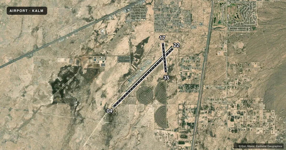
Runways & pattern
Full pagePattern entry · RWY 04
RIGHT TRAFFIC| Runway | Heading (°M) | Length | Surface | Traffic |
|---|---|---|---|---|
| 04/22 | 38° / 218° | 9,207 ft | ASPH | 04 R |
| 17/35 | 166° / 346° | 3,257 ft | DIRT | 35 R |
Runway end performance
| End | TORA | TODA | ASDA | LDA | VGSI | Approach lights | Obstruction |
|---|---|---|---|---|---|---|---|
| 04 | 9,207' | 9,207' | 9,207' | 9,207' | PAPI 4-box right(3°) | — | — |
| 22 | 9,207' | 9,207' | 9,207' | 9,207' | VASI 2-box left(3°) | — | — |
Declared distances in feet. TORA = takeoff run available, TODA = takeoff distance, ASDA = accelerate-stop, LDA = landing distance.
Airport sketch
Runways drawn to scale from FAA survey coordinates, rendered over satellite imagery. Not for navigation.
Approaches & charts
Services on the field
Fuel grades, oxygen, maintenance, ramp storage and lighting — as declared to the FAA by the airport operator.
Fuel & services
- Fuel
- 100LLA1+
- Oxygen (bulk)
- High pressure
- Airframe repair
- Major
- Power plant repair
- Major
- Other services
- AMB,AVNCS,CHTR,GLD,INSTR,TOW
Ramp & ground
- Transient storage
- Tie-down
- Hangar
- Landing fee
- No fee published
- Customs
- Not available
- Lighting schedule
- SEE RMK
- Beacon schedule
- SS-SR
- Beacon
- White / Green (civil land)(WG)
- Wind indicator
- Lighted
- Segmented circle
- Yes
Fuel & FBOs
Cheapest 100LL and Jet A on the field and nearby. Always confirm with the FBO before taxi.
Airport notes
Surface conditions, obstructions, local procedures, lighting outages and other notes published with each FAA cycle.
General notes
- 8000 FT MTS 4 NM E.
- VFR OPS BTN EL PASO & ALAMOGORDO-WHITE SANDS FLW & RMN W OF HWY 54 & TRAIN TRACKS; RMN CLEAR OF RSTRD ASP.
- MIL, GLIDER, ULTRALIGHT & UNMANNED AERIAL VEHICLE ACT ON & INVOF ARPT.
- HOLLOMAN RAPCON IFR SDBY SVC 60 MIN RECALL - 575-572-7575.
- FOR CD IF UNA TO CTC ON FSS FREQ, CTC ALBUQUERQUE ARTCC AT 505-856-4561.
Lighting notes
- ACTVT PAPI RWY 04; VASI RWY 22; MIRL RWY 04/22 - CTAF. MIRL RWY 04/22 PRESET MED INTST; INCR INTST - CTAF.
Runway surface & condition
- 04/22RWY 22 CALM WIND RWY WHEN LESS THAN 5 KTS. 200 FT BLAST PADS MKD BY CHEVRONS.
- 17/35OPS DURG WET COND NA; FOR COND - 575-551-6245.
Other notes
- 1AFT HR - 575-437-2474.
VFR map & nearby airports
VFR sectional. Tap any ICAO chip to open that airport.
Key facts · KALM
Answer card- ICAO
- KALM
- Name
- ALAMOGORDO-WHITE SANDS RGNL
- Location
- ALAMOGORDO, NEW MEXICO
- Elevation
- 4,199.9 ft MSL
- Traffic pattern altitude
- 5,199.9 ft MSL (1,000 AGL)
- Control tower
- Non-towered (use CTAF)
- Total runways
- 2
- Longest runway
- 04/22 · 9,207 ft
- Published ILS approaches
- 0
- Published frequencies
- 6
- Magnetic variation
- 8°
- Current flight rules
- VFR
- Current wind
- 000° at 0 kt
- Favored runway now
- –
Alamogordo-White Sands Rgnl sits in Alamogordo, New Mexico. Field elevation is 4,199.9 ft MSL. The airport has two runways. The longest is 04/22 at 9,207 ft. Runway 17/35 is 3,257 ft and dirt. There is no control tower. CTAF and UNICOM are both 122.8. No ILS approaches are published.
Pattern altitude is not published. Use 1,000 ft AGL for light piston traffic unless the current Chart Supplement says otherwise. That puts the standard pattern at about 5,200 ft MSL here. Exile Aviation is on the field. It carries 100LL and Jet A. The published after-hours contact number is the same as the FBO phone.
This is high desert country. Density altitude can be a real factor. There are 8,000 ft mountains 4 NM east. VFR traffic between El Paso and Alamogordo-White Sands is expected to stay west of Highway 54. It should also stay west of the train tracks. Stay clear of restricted airspace. Runway 22 is the calm wind runway when winds are under 5 knots. Runway 04 has PAPI. Runway 22 has VASI. Medium intensity edge lights on 04/22 are controlled by CTAF. Watch the brush near the 04 end. Military, glider, ultralight and UAV activity also occurs on and near the airport.