METAR & TAF KELP
Current METAR
Observed 20:51Z
KELP 272051Z 31008KT 10SM BKN110 BKN160 BKN250 40/09 A2994 RMK AO2 SLP047 CB DSNT N-NE AND S MOV W SHRA E-SE T04000094 58023
- Wind
- 310° @ 8 kt
- Visibility
- 10 SM
- Temp / Dew
- 40°C / 9°C
- Altimeter
- 29.94 inHg
- Clouds
- BKN
- Density alt
- 7,888 ft
- Ceiling
- 11,000 ft AGL
- Rules
- VFR
Airport info & contacts
Manager on record, flight service, ARTCC, attendance schedule and pattern altitude — published by the FAA and refreshed every 28 days.
Location
- From city
- 4 NM NE
- VFR sectional
- EL PASO
- ARTCC
- ZAB · ALBUQUERQUE
- NOTAM facility
- ELP (NOTAM-D)
Airport manager
- Name
- YVETTE HERNANDEZ
- Phone
- 915-212-0333
- Address
- 6701 CONVAIR RD, EL PASO TX 79925
Flight service · Hours
- FSS ABQ
- ALBUQUERQUE1-800-WX-BRIEF
- Attendance
- ALL
Frequencies
Tap any row to copy the frequency to your clipboard.
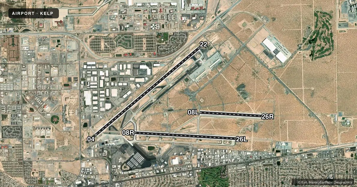
Runways & pattern
Full pagePattern entry · RWY 26L
LEFT TRAFFIC| Runway | Heading (°M) | Length | Surface | Traffic |
|---|---|---|---|---|
| 04/22 | 42° / 222° | 12,020 ft | ASPH-CONC | 22 R |
| 08R/26LFavored | 85° / 265° | 9,025 ft | ASPH-CONC | 08R R |
| 08L/26R | 85° / 265° | 5,499 ft | CONC | 26R R |
Runway end performance
| End | TORA | TODA | ASDA | LDA | VGSI | Approach lights | Obstruction |
|---|---|---|---|---|---|---|---|
| 04 | 12,020' | 12,020' | 12,020' | 12,020' | PAPI 4-box left(3°) | — | — |
| 22 | 12,020' | 12,020' | 12,020' | 12,020' | PAPI 4-box right(3°) | MALSR | — |
| 08R | 9,025' | 9,025' | 9,025' | 9,025' | PAPI 4-box left(3°) | — | — |
| 26L | 9,025' | 9,025' | 9,025' | 9,025' | PAPI 4-box right(3°) | MALSR | — |
| 08L | 5,499' | 5,499' | 5,499' | 5,499' | — | — | — |
| 26R | 5,499' | 5,499' | 5,499' | 5,499' | — | — | — |
Declared distances in feet. TORA = takeoff run available, TODA = takeoff distance, ASDA = accelerate-stop, LDA = landing distance.
Airport sketch
Runways drawn to scale from FAA survey coordinates, rendered over satellite imagery. Not for navigation.
Approaches & charts
ILS · 2
Services on the field
Fuel grades, oxygen, maintenance, ramp storage and lighting — as declared to the FAA by the airport operator.
Fuel & services
- Fuel
- 100LLA1+
- Oxygen (bottled)
- Low pressure
- Oxygen (bulk)
- Low pressure
- Airframe repair
- Major
- Power plant repair
- Major
- Other services
- AFRT,AMB,AVNCS,CARGO,CHTR,INSTR,RNTL,SALES
Ramp & ground
- Transient storage
- Tie-down
- Hangar
- Landing fee
- No fee published
- Customs
- Available
- Lighting schedule
- SS-SR
- Beacon schedule
- SS-SR
- Beacon
- White / Green (civil land)(WG)
- Wind indicator
- Lighted
- Segmented circle
- No
Fuel & FBOs
Cheapest 100LL and Jet A on the field and nearby. Always confirm with the FBO before taxi.
Airport notes
Surface conditions, obstructions, local procedures, lighting outages and other notes published with each FAA cycle.
General notes
- 24 HR PPR CLASS A EXPLOSIVES CTC 915-212-0333.
- CTN: BIGGS AAF 2NM NW RWY 22 CAN BE MISTAKEN FOR ELP RWY 22.
- TWY T1; TWY A NE OF TWY A7; TWY A8 AND TWY A9 NOT VISIBLE FM ATCT.
- RWY 4 HOLDING POSITION MARKINGS ARE LOCATED ADJACENT TO THE TERMINAL APRON ON TWY T1, T2
- MILITARY USERS SHOULD REVIEW NOISE ABATEMENT PROCEDURES LISTED FOR BIGGS AAF.
- NOISE ABATEMENT PROCEDURES IN EFFECT, CTC ATCT FOR DETAILS.
- ENGINE POWER IS RSTRD TO IDLE POWER ON ONE ENGINE AT A TIME FOR MAX 5 MIN ON ANY TERMINAL OR PARKING APRONS, CROSS-BLEED STARTS OR OTHER PRE DEP ACTIVITY ON MOVEMENT AREAS ONLY, MAINT OR OTR RQRMT NEEDING LONGER OR HIGHER POWER CTC TWR FOR DIRECTIONS TO DESIGNATED RUNUP AREAS.
- ILS MARKINGS ON THE TERMINAL RAMP APPLY TO RWY 8R/26L APPROACH AND DEPARTURES
- AIRCRAFT ON THE TERMINAL RAMP MUST CONTACT EL PASO GROUND FOR PUSHBACK AND TAXI INSTRUCTIONS
Fuel notes
- 100LLFOR FUEL AT MIL RAMP CTC ATLANTIC AVIATION 122.95 OR 915-779-2831.
Runway surface & condition
- 04/22PCR VALUE: 680/F/B/X/T
- 08L/26RPCR VALUE: 100/R/C/W/T
- 08R/26LPCR VALUE: 520/F/B/X/T
- 08L/26RRWY 08L/26R NOT AVBL FOR PART 121/PART 380 OPS WITH SKED PAX CARRYING OPS MORE THAN 9 PAX SEATS AND NON-SKED PAX CARRYING OPS MORE THAN 30 PAX SEATS.
Other notes
- TPA: 1038 FT AGL SMALL ACFT, 1542 FT AGL TURBOJET, 2042 FT AGL OVERHEAD APCH.
- 04/22RWY 4/22 206 FEET CONC, 10,814 FEET ASPH, 1,000 FEET CONC.
- 08R/26LRWY 08R/26L 7,780 FEET ASPH, 1,247 FEET CONC.
VFR map & nearby airports
VFR sectional. Tap any ICAO chip to open that airport.
Key facts · KELP
Answer card- ICAO
- KELP
- Name
- EL PASO INTL
- Location
- EL PASO, TEXAS
- Elevation
- 3,961.6 ft MSL
- Traffic pattern altitude
- 4,961.6 ft MSL (1,000 AGL)
- Control tower
- Towered · 24
- Total runways
- 3
- Longest runway
- 04/22 · 12,020 ft
- Published ILS approaches
- 2
- Published frequencies
- 22
- Magnetic variation
- 8°
- Current flight rules
- VFR
- Current wind
- 310° at 8 kt
- Favored runway now
- RWY 26L
El Paso Intl sits in El Paso, Texas at 3,961.6 ft MSL. It has three runways. The longest is 04/22 at 12,020 ft. The tower is open 24 hours. Two ILS approaches are published for runway ends 04 and 22. The field is in Class C airspace, so expect normal tower and approach coordination on arrival and departure.
Pattern altitude is not published in the usual way for this field. The published traffic pattern altitudes are 1,038 ft AGL for small aircraft, 1,542 ft AGL for turbojets and 2,042 ft AGL for overhead approaches. That is worth checking before you join the pattern.
Million Air is on the field. It carries 100LL, Jet A and Jet A Prist. Atlantic Aviation is also on the field. It carries 100LL and Jet A. If you need fuel at the military ramp, contact Atlantic Aviation on 122.95 or by phone before you taxi over.
Noise abatement procedures are in effect. Contact the tower for details. The published remarks also note that some taxiways are not visible from the tower. Taxi carefully and expect close tower coordination on the ramp. Runway 08L/26R is not available for certain large scheduled or passenger-carrying Part 121 and Part 380 operations. High field elevation also means performance planning matters. That is especially true on hot days.