METAR & TAF KSXU
Current METAR
Observed 18:15Z
KSXU 271815Z AUTO 16007KT 110V180 10SM CLR 36/13 A3006 RMK AO2
- Wind
- 160° @ 7 kt
- Visibility
- 10 SM
- Temp / Dew
- 36°C / 13°C
- Altimeter
- 30.06 inHg
- Clouds
- CLR
- Density alt
- 8,288 ft
- Ceiling
- Unlimited
- Rules
- VFR
Airport info & contacts
Manager on record, flight service, ARTCC, attendance schedule and pattern altitude — published by the FAA and refreshed every 28 days.
Location
- From city
- 3 NM E
- VFR sectional
- ALBUQUERQUE
- ARTCC
- ZAB · ALBUQUERQUE
- NOTAM facility
- ABQ (NOTAM-D)
Airport manager
- Name
- ANTHONY SENA
- Phone
- 575-799-2296
- Address
- 244 S 5TH ST, SANTA ROSA NM 88435
Flight service · Hours
- FSS ABQ
- ALBUQUERQUE1-800-WX-BRIEF
- Attendance
- Unattended
Frequencies
Tap any row to copy the frequency to your clipboard.
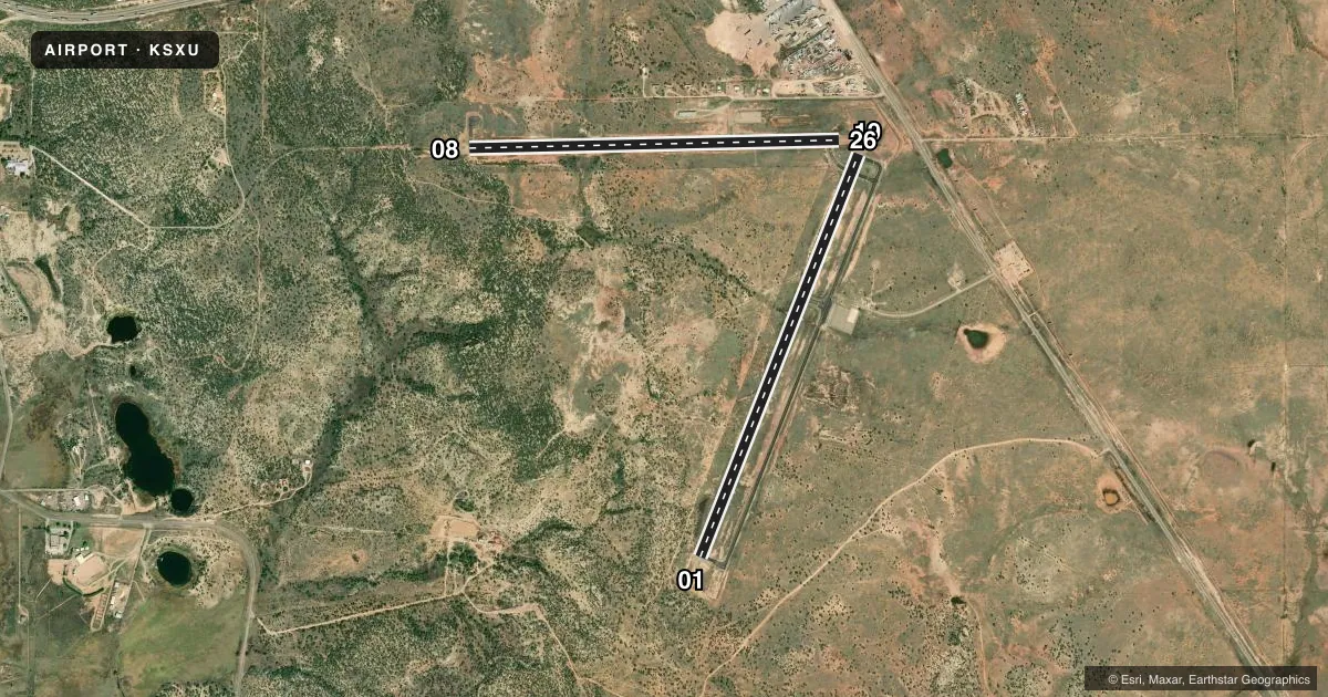
Runways & pattern
Full pagePattern entry · RWY 19
LEFT TRAFFIC| Runway | Heading (°M) | Length | Surface | Traffic |
|---|---|---|---|---|
| 01/19Favored | 12° / 192° | 5,013 ft | ASPH | Standard L |
| 08/26 | 79° / 259° | 4,294 ft | ASPH | Standard L |
Runway end performance
| End | TORA | TODA | ASDA | LDA | VGSI | Approach lights | Obstruction |
|---|---|---|---|---|---|---|---|
| 19 | — | — | — | — | PAPI 2-box left(2.45°) | — | — |
| 26 | — | — | — | — | PAPI 2-box left(3.36°) | — | — |
Declared distances in feet. TORA = takeoff run available, TODA = takeoff distance, ASDA = accelerate-stop, LDA = landing distance.
Airport sketch
Runways drawn to scale from FAA survey coordinates, rendered over satellite imagery. Not for navigation.
Approaches & charts
Services on the field
Fuel grades, oxygen, maintenance, ramp storage and lighting — as declared to the FAA by the airport operator.
Fuel & services
- Fuel
- 100LLA1+
Ramp & ground
- Transient storage
- Tie-down
- Hangar
- Landing fee
- No fee published
- Customs
- Not available
- Lighting schedule
- SEE RMK
- Beacon schedule
- SS-SR
- Beacon
- White / Green (civil land)(WG)
- Wind indicator
- Lighted
- Segmented circle
- Yes
Fuel & FBOs
Cheapest 100LL and Jet A on the field and nearby. Always confirm with the FBO before taxi.
Airport notes
Surface conditions, obstructions, local procedures, lighting outages and other notes published with each FAA cycle.
General notes
- WILDLIFE ON & INVOF ARPT.
- GATE ACES - 9942.
- FOR CD CTC ALBUQUERQUE ARTCC AT 505-856-4861.
Lighting notes
- ACTVT MIRL RWY 01/19 & 08/26 PRESET MED INTST DUSK-2200; INCR INTST CTAF. AFT 2200 ACTVT - CTAF.
Fuel notes
- 100LLAVBL H24 WITH CREDIT CARD.
Runway surface & condition
- 01/19+5 FT BERM W OF CNTRLN NEAR RWY 19 TOUCHDOWN BARS.
Approach & departure obstructions
- 01+3 FT BRUSH 0-130 FT FM THR 10 FT R & 80 FT L.
- 08+10 FT ACES ROAD 10-200 FT FM RWY END ON CNTRLN; 2-3 FT BRUSH 20-200 FT FM RWY END 40-125 FT L & 50-125 FT R OF CNTRLN.
Other notes
- CALL AHEAD - AMGR.
- MANAGEREMERG - POLICE 575-472-3605.
VFR map & nearby airports
VFR sectional. Tap any ICAO chip to open that airport.
Key facts · KSXU
Answer card- ICAO
- KSXU
- Name
- SANTA ROSA ROUTE 66
- Location
- SANTA ROSA, NEW MEXICO
- Elevation
- 4,791.4 ft MSL
- Traffic pattern altitude
- 5,791.4 ft MSL (1,000 AGL)
- Control tower
- Non-towered (use CTAF)
- Total runways
- 2
- Longest runway
- 01/19 · 5,013 ft
- Published ILS approaches
- 0
- Published frequencies
- 2
- Magnetic variation
- 10°
- Current flight rules
- VFR
- Current wind
- 160° at 7 kt
- Favored runway now
- RWY 19
Santa Rosa Route 66 Airport sits in Santa Rosa, New Mexico. Field elevation is 4,791.4 ft MSL. The airport has two asphalt runways. The longest is runway 01/19 at 5,013 ft. There is no control tower. CTAF and UNICOM are both 122.8. No ILS approaches are published.
Pattern altitude is not published. Use the standard 1,000 ft AGL pattern for light piston traffic unless the current Chart Supplement or local procedures say otherwise. The field is high enough that density altitude can matter, especially on warm days. Expect a little less performance than you would at a low-elevation strip.
Santa Rosa Route 66 Airport is the on-field FBO. It carries AVGAS 100LL and JET A. 100LL is listed as available 24 hours with credit card. The airport remarks also say to call ahead to the airport manager. Published notes mention wildlife on and near the airport. There are also runway-end obstructions near 01 and 19, plus a small access road near the 08 end. The runway lights on 01/19 and 08/26 are medium intensity. They are preset dusk to 2200. After 2200, activate them on CTAF. For clearance delivery, contact Albuquerque ARTCC. Ground access uses gate code 9942.