METAR & TAF KTCC
Current METAR
Observed 16:53Z
KTCC 271653Z AUTO 20005KT 10SM CLR 34/13 A3001 RMK AO2 SLP082 T03390133 $
- Wind
- 200° @ 5 kt
- Visibility
- 10 SM
- Temp / Dew
- 34°C / 13°C
- Altimeter
- 30.01 inHg
- Clouds
- CLR
- Density alt
- 7,209 ft
- Ceiling
- Unlimited
- Rules
- VFR
Airport info & contacts
Manager on record, flight service, ARTCC, attendance schedule and pattern altitude — published by the FAA and refreshed every 28 days.
Location
- From city
- 6 NM E
- VFR sectional
- ALBUQUERQUE
- ARTCC
- ZAB · ALBUQUERQUE
- NOTAM facility
- TCC (NOTAM-D)
Airport manager
- Name
- JIM SEWELL
- Phone
- 575-461-3229
- Address
- 6352 QRA1 ROAD, TUCUMCARI NM 88401
Flight service · Hours
- FSS ABQ
- ALBUQUERQUE1-800-WX-BRIEF
- Attendance
- 0700-1700
Frequencies
Tap any row to copy the frequency to your clipboard.
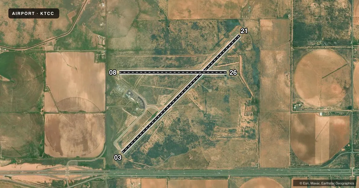
Runways & pattern
Full pagePattern entry · RWY 21
LEFT TRAFFIC| Runway | Heading (°M) | Length | Surface | Traffic |
|---|---|---|---|---|
| 03/21Favored | 33° / 213° | 7,104 ft | ASPH | Standard L |
| 08/26 | 78° / 258° | 4,600 ft | ASPH | Standard L |
Runway end performance
| End | TORA | TODA | ASDA | LDA | VGSI | Approach lights | Obstruction |
|---|---|---|---|---|---|---|---|
| 21 | — | — | — | — | VASI 4-box left(3°) | — | — |
Declared distances in feet. TORA = takeoff run available, TODA = takeoff distance, ASDA = accelerate-stop, LDA = landing distance.
Airport sketch
Runways drawn to scale from FAA survey coordinates, rendered over satellite imagery. Not for navigation.
Approaches & charts
Services on the field
Fuel grades, oxygen, maintenance, ramp storage and lighting — as declared to the FAA by the airport operator.
Fuel & services
- Fuel
- 100LLA+
- Other services
- AMB
Ramp & ground
- Transient storage
- Tie-down
- Hangar
- Landing fee
- No fee published
- Customs
- Not available
- Lighting schedule
- SEE RMK
- Beacon schedule
- SS-SR
- Beacon
- White / Green (civil land)(WG)
- Wind indicator
- Lighted
- Segmented circle
- Yes
Fuel & FBOs
Cheapest 100LL and Jet A on the field and nearby. Always confirm with the FBO before taxi.
Airport notes
Surface conditions, obstructions, local procedures, lighting outages and other notes published with each FAA cycle.
General notes
- FOR CD IF UNA TO CTC ON FSS FREQ, CTC ALBUQUERQUE ARTCC AT 505-856-4561.
- AFT HR FUEL SELF SVC WITH CREDIT CARD.
Lighting notes
- ACTVT VASI RWY 21; MIRL RWY 03/21 & 08/26 - CTAF.
Other notes
- FOR AVBL - AMGR.
- 2CLSD FED HOL.
- MANAGEREMERG - 575-461-2280.
VFR map & nearby airports
VFR sectional. Tap any ICAO chip to open that airport.
Key facts · KTCC
Answer card- ICAO
- KTCC
- Name
- TUCUMCARI MUNI
- Location
- TUCUMCARI, NEW MEXICO
- Elevation
- 4,064.9 ft MSL
- Traffic pattern altitude
- 5,064.9 ft MSL (1,000 AGL)
- Control tower
- Non-towered (use CTAF)
- Total runways
- 2
- Longest runway
- 03/21 · 7,104 ft
- Published ILS approaches
- 0
- Published frequencies
- 2
- Magnetic variation
- 12°
- Current flight rules
- VFR
- Current wind
- 200° at 5 kt
- Favored runway now
- RWY 21
Tucumcari Muni sits in Tucumcari, New Mexico at 4,064.9 ft MSL. It has two asphalt runways. The longest is runway 03/21 at 7,104 ft. Runway 08/26 is 4,600 ft. There is no control tower. CTAF and UNICOM are both 122.95.
No ILS approaches are published here. The field uses a standard pattern altitude of 1,000 ft AGL for light piston traffic. That puts the pattern at about 5,065 ft MSL. Runway 21 has a visual approach slope indicator. Medium intensity runway lights are activated on CTAF for both runways.
The on-field FBO is Tucumcari Municipal Airport. It carries 100LL and Jet A Prist. After hours, fuel is self-service with credit card. The airport is closed on federal holidays. If you need current availability, call the airport manager before you go. For clearance delivery, if you cannot raise Flight Service, Albuquerque ARTCC is listed as a backup contact.
This is a high-elevation New Mexico field. Expect thinner air than you get at lowland airports. Takeoff and climb performance deserve a careful look, especially on warm days. Runway 03/21 gives you the longest pavement. That is the one most crews will want to plan around when weight or density altitude is a factor.