METAR & TAF KFSU
KFSU does not publish a METAR.
Showing the nearest reporting station: KSXU (SANTA ROSA ROUTE 66) · 34.1 NM away. Conditions at KFSU may differ.
METAR · KSXU
Observed 17:15Z
KSXU 271715Z AUTO 14008KT 10SM CLR 34/13 A3007 RMK AO2
- Wind
- 140° @ 8 kt
- Visibility
- 10 SM
- Temp / Dew
- 34°C / 13°C
- Altimeter
- 30.07 inHg
- Clouds
- CLR
- Density alt
- 7,258 ft
- Ceiling
- Unlimited
- Rules
- VFR
Airport info & contacts
Manager on record, flight service, ARTCC, attendance schedule and pattern altitude — published by the FAA and refreshed every 28 days.
Location
- From city
- 2 NM NE
- VFR sectional
- ALBUQUERQUE
- ARTCC
- ZAB · ALBUQUERQUE
- NOTAM facility
- ABQ (NOTAM-D)
Airport manager
- Name
- MAYOR
- Phone
- 575-355-2401
- Address
- BOX 180, FORT SUMNER NM 88119
Flight service · Hours
- FSS ABQ
- ALBUQUERQUE1-800-WX-BRIEF
- Attendance
- MON-FRI · 0700-1600
Frequencies
Tap any row to copy the frequency to your clipboard.
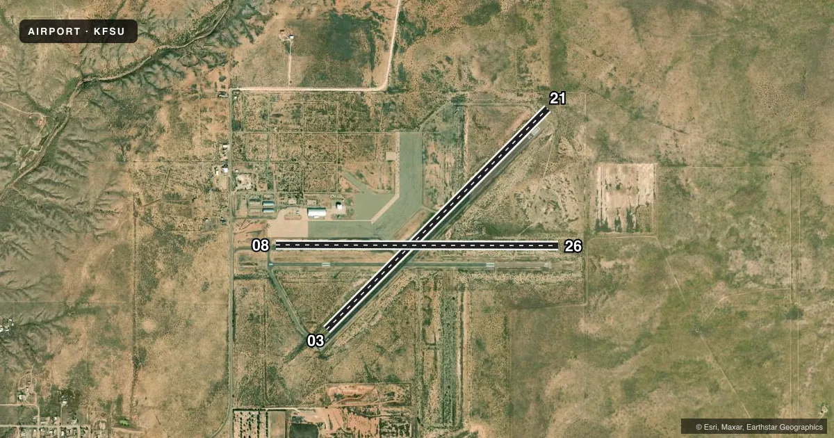
Runways & pattern
Full pagePattern entry · RWY 08
LEFT TRAFFIC| Runway | Heading (°M) | Length | Surface | Traffic |
|---|---|---|---|---|
| 03/21 | 35° / 215° | 5,800 ft | ASPH | Standard L |
| 08/26Favored | 80° / 260° | 5,250 ft | ASPH | Standard L |
Runway end performance
| End | TORA | TODA | ASDA | LDA | VGSI | Approach lights | Obstruction |
|---|---|---|---|---|---|---|---|
| 03 | — | — | — | — | — | — | 3', brush, 201' from thr, 75' R of cntrln, slope 0 |
| 21 | — | — | — | — | — | — | 6', brush, 226' from thr, 65' R of cntrln, slope 4 |
| 26 | — | — | — | — | — | — | 8', brush, 235' from thr, 100' R of cntrln, slope 4 |
Declared distances in feet. TORA = takeoff run available, TODA = takeoff distance, ASDA = accelerate-stop, LDA = landing distance.
Airport sketch
Runways drawn to scale from FAA survey coordinates, rendered over satellite imagery. Not for navigation.
Approaches & charts
Services on the field
Fuel grades, oxygen, maintenance, ramp storage and lighting — as declared to the FAA by the airport operator.
Fuel & services
- Fuel
- Not available
Ramp & ground
- Transient storage
- Tie-down
- Landing fee
- No fee published
- Customs
- Not available
- Lighting schedule
- SEE RMK
- Beacon schedule
- SS-SR
- Beacon
- White / Green (civil land)(WG)
- Wind indicator
- Lighted
- Segmented circle
- Yes
Fuel & FBOs
Cheapest 100LL and Jet A on the field and nearby. Always confirm with the FBO before taxi.
Airport notes
Surface conditions, obstructions, local procedures, lighting outages and other notes published with each FAA cycle.
General notes
- GATE ACES 2019.
- FOR CD CTC ALBUQUERQUE ARTCC AT 505-856-4861.
Lighting notes
- DUSK-DAWN: ACTVT MIRL RWY 08/26 - CTAF. MIRL RWY 03/21 PRESET LOW INTST TILL 2200; AFT 2200 ACTVT - CTAF.
Approach & departure obstructions
- 0310 FT BRUSH 75-200 FT FM THR 65-110 FT R OF CNTRLN; 6 FT BRUSH 30-300 FT FM THR 50-100 FT L OF CNTRLN.
- 08+4 FT BRUSH 0-150 FT FM THR 90 FT R OF CNTRLN.
- 21+4 FT BRUSH 100-200 FT FM THR 100 FT L OF CNTRLN.
- 265 FT BRUSH UP TO 200 FT FM THR 100 FT L & 90 FT R OF CNTRLN.
- 03CTLG OBTNS EXCEEDS 45 DEG SLOPE.
Other notes
- 1AFT HR - 575-355-2405.
- OWNERJAMIE WALL OR LOUIE GALLEGOS.
VFR map & nearby airports
VFR sectional. Tap any ICAO chip to open that airport.
Key facts · KFSU
Answer card- ICAO
- KFSU
- Name
- FORT SUMNER MUNI
- Location
- FORT SUMNER, NEW MEXICO
- Elevation
- 4,164.7 ft MSL
- Traffic pattern altitude
- 5,164.7 ft MSL (1,000 AGL)
- Control tower
- Non-towered (use CTAF)
- Total runways
- 2
- Longest runway
- 03/21 · 5,800 ft
- Published ILS approaches
- 0
- Published frequencies
- 2
- Magnetic variation
- 10°
- Current flight rules
- VFR
- Current wind
- 140° at 8 kt
- Favored runway now
- RWY 08
Fort Sumner Muni sits in Fort Sumner, New Mexico at 4,164.7 ft MSL. The field has two asphalt runways. Runway 03/21 is the longest at 5,800 ft. Runway 08/26 is 5,250 ft. This is a non-towered airport. CTAF and UNICOM are both 122.8. No ILS approaches are published here.
Pattern altitude is not published. Use the standard 1,000 ft AGL pattern for light piston traffic unless local guidance says otherwise. That puts the pattern about 5,165 ft MSL based on the field elevation. The published remarks call out brush near several runway ends. That matters on short final and during rollout. Runway lighting is pilot-activated on CTAF. Runway 08/26 lights are medium intensity from dusk to dawn. Runway 03/21 lights are preset to low intensity until 2200. After 2200, activate them on CTAF.
No on-field FBOs are listed. Plan on self-briefing the field and calling ahead if you need local help. After hours, the published contact number is 575-355-2405. For clearance delivery, contact Albuquerque ARTCC at 505-856-4861. This is a high-elevation New Mexico airport, so expect density altitude to matter, especially on warm days.