METAR & TAF CO4
CO4 does not publish a METAR.
Showing the nearest reporting station: KFLY (MEADOW LAKE) · 8.5 NM away. Conditions at CO4 may differ.
METAR · KFLY
Observed 13:35Z
KFLY 271335Z AUTO 35014G20KT 10SM CLR 25/08 A3026 RMK AO2 T02450080
- Wind
- 350° @ 14G20 kt
- Visibility
- 10 SM
- Temp / Dew
- 25°C / 8°C
- Altimeter
- 30.26 inHg
- Clouds
- CLR
- Density alt
- 8,398 ft
- Ceiling
- Unlimited
- Rules
- VFR
Airport info & contacts
Manager on record, flight service, ARTCC, attendance schedule and pattern altitude — published by the FAA and refreshed every 28 days.
Location
- From city
- 3 NM NW
- VFR sectional
- DENVER
- ARTCC
- ZDV · DENVER
- NOTAM facility
- COS (NOTAM-D)
Airport manager
- Name
- DEBBIE TRIVETTE
- Phone
- (719) 306-3021
- Address
- 3060 FLYING VIEW, CALHAN CO 80808
Flight service · Hours
- FSS DEN
- DENVER1-800-WX-BRIEF
- Attendance
- Unattended
Frequencies
Tap any row to copy the frequency to your clipboard.
Runways & pattern
Full pagePattern entry · RWY 35L
RIGHT TRAFFIC| Runway | Heading (°M) | Length | Surface | Traffic |
|---|---|---|---|---|
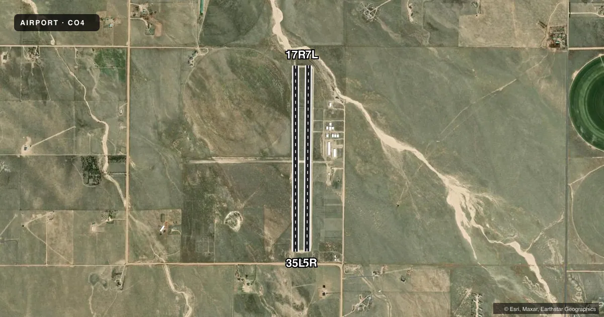
| 17R/35LFavored | 169° / 349° | 4,500 ft | ASPH | 35L R |
| 17L/35R | 169° / 349° | 4,500 ft | GRVL-DIRT | Standard L |
Runway end performance
| End | TORA | TODA | ASDA | LDA | VGSI | Approach lights | Obstruction |
|---|---|---|---|---|---|---|---|
| 17R | — | — | — | — | — | — | 6', fence, 201' from thr, 105' R of cntrln, slope 0 |
| 35L | — | — | — | — | — | — | 11', road, 270' from thr, 0' R of cntrln, slope 6 |
| 17L | — | — | — | — | — | — | 2', berm, 9' from thr, 0' R of cntrln, slope 4 |
Declared distances in feet. TORA = takeoff run available, TODA = takeoff distance, ASDA = accelerate-stop, LDA = landing distance.
Airport sketch
Runways drawn to scale from FAA survey coordinates, rendered over satellite imagery. Not for navigation.
Approaches & charts
Services on the field
Fuel grades, oxygen, maintenance, ramp storage and lighting — as declared to the FAA by the airport operator.
Fuel & services
- Fuel
- 100LL
Ramp & ground
- Transient storage
- Tie-down
- Hangar
- Landing fee
- No fee published
- Lighting schedule
- SEE RMK
- Wind indicator
- Yes
- Segmented circle
- Yes
Fuel & FBOs
Cheapest 100LL and Jet A on the field and nearby. Always confirm with the FBO before taxi.
Airport notes
Surface conditions, obstructions, local procedures, lighting outages and other notes published with each FAA cycle.
General notes
- COML ACFT FEE - AMGR.
- ALERT: MIL TRNG INVOF COLORADO SPRINGS & PUEBLO COLORADO.
- GLIDER OPS INVOF OF ARPT.
- TWIN TANDEM ROTARY HEL NA.
- FOR CD CTC COLORADO SPRINGS APCH AT 719-556-9105.
Lighting notes
- ACTVT MIRL RWY 17R/35L; CALL AHEAD 1 HOUR PRIOR - AMGR.
Fuel notes
- 100LLAPPT ONLY.
Runway surface & condition
- 08/262 IN BUMP AT RWY 17R/35L INTXN.
- 17R/35LCLSD TO HEL.
Approach & departure obstructions
- 085 FT LGT POLE R SIDE OF RWY 35L 115 FT FM THR BTW THR & PAPI; +35 FT PWR LINE 1500 FT FM THR BOTH SIDES; +4 FT FENCE 125 FT FM CNTRLN N OF RWY & W OF RWY 17R/35L INTXN.
- 17L+5 FT BERM 50 FT & 150 FT FM THR BOTH SIDES.
- 17R+4 FT FENCE 100 FT R OF RWY FIRST 2500 FT; +4 FT FENCE 375 FT FM RWY END BOTH SIDES; -2 FT TRRN 280 FT FM RWY END BOTH SIDES.
- 26+4 FT FENCE 260 FT FM THR BOTH SIDES; +15 FT BLDG 130 FT L OF THR; +15FT ROAD 240 FT FM THR BOTH SIDES.
- 35L+4 FT FENCE 260 FT FM THR BOTH SIDES; +15 FT ROAD 250 FT FM THR BOTH SIDES. 5 FT FT LGT POLE R SIDE BTW THR & PAPI 115 FT FM THR.
- 35R+4 FT CONCRETE BOX 100 FT FM THR 50 FT R OF CNTRLN.
- 17RRWY 17R/35L THLD MKGS WORN & DFCLT TO READ.
- 35LRWY 17R/35L THLD MKGS WORN & DFCLT TO READ.
- 17RTHR RED/GREEN REFLECTORS; RWY WHITE REFLECTORS BOTH SIDES.
- 35LTHR RED/GREEN REFLECTORS; RWY WHITE REFLECTORS BOTH SIDES.
Other notes
- NSTD MKD WITH WHITE ROCKS.
- NSTD WIND TEE MADE FM BARRELS.
- MANAGERCORY STEINKE - 719-460-7941.
VFR map & nearby airports
VFR sectional. Tap any ICAO chip to open that airport.
Key facts · CO4
Answer card- ICAO
- CO4
- Name
- COLORADO SPRINGS EAST
- Location
- ELLICOTT, COLORADO
- Elevation
- 6,145 ft MSL
- Traffic pattern altitude
- 7,145 ft MSL (1,000 AGL)
- Control tower
- Non-towered (use CTAF)
- Total runways
- 2
- Longest runway
- 17R/35L · 4,500 ft
- Published ILS approaches
- 0
- Published frequencies
- 1
- Magnetic variation
- 11°
- Current flight rules
- VFR
- Current wind
- 350° at 14 kt
- Favored runway now
- RWY 35L
Colorado Springs East (CO4) sits in Ellicott, Colorado, east of Colorado Springs. The field elevation is 6,145 ft MSL. It has two runways. The longest is 4,500 ft. There is no control tower. CTAF is 122.9. No ILS approaches are published here.
The pattern altitude is not published. Use the standard 1,000 ft AGL pattern unless the current FAA Chart Supplement says otherwise. That puts you at about 7,145 ft MSL. The airport sits high enough that density altitude will matter on warm days. Expect performance to change fast.
Runway 17R/35L is asphalt. Runway 17L/35R is gravel-dirt. Published remarks say 17R/35L has medium intensity runway lights. Call ahead about one hour prior with the airport manager if you need the lights. The remarks also say 100LL is available by appointment only. No on-field FBOs are listed. Contact the airport operator directly before arrival if you need fuel or local handling.
There are a few surface and obstacle notes that matter on a first visit. Threshold markings on 17R/35L are worn and hard to read. Runway 17L has a 5 ft berm near the threshold area. There are fences, a road, a light pole and a power line noted near the runway environment. Review the current Chart Supplement before you go. If you need clearance delivery, the published contact is Colorado Springs Approach.