METAR & TAF KLIC
Current METAR
Observed 14:55Z
KLIC 271455Z AUTO 03004KT 10SM CLR 27/16 A3014 RMK AO2 SLP109 T02720161 51013 $
- Wind
- 030° @ 4 kt
- Visibility
- 10 SM
- Temp / Dew
- 27°C / 16°C
- Altimeter
- 30.14 inHg
- Clouds
- CLR
- Density alt
- 7,831 ft
- Ceiling
- Unlimited
- Rules
- VFR
Airport info & contacts
Manager on record, flight service, ARTCC, attendance schedule and pattern altitude — published by the FAA and refreshed every 28 days.
Location
- From city
- 1 NM NE
- VFR sectional
- WICHITA
- ARTCC
- ZDV · DENVER
- NOTAM facility
- LIC (NOTAM-D)
Airport manager
- Name
- GREG TACHA
- Phone
- 719-775-2346
- Address
- TOWN OF LIMON, BOX 9, LIMON CO 80828
Flight service · Hours
- FSS DEN
- DENVER1-800-WX-BRIEF
- Attendance
- Unattended
Frequencies
Tap any row to copy the frequency to your clipboard.
Runways & pattern
Full pagePattern entry · RWY 34
LEFT TRAFFICRunway end performance
| End | TORA | TODA | ASDA | LDA | VGSI | Approach lights | Obstruction |
|---|---|---|---|---|---|---|---|
| 16 | — | — | — | — | PAPI 2-box left(3°) | — | — |
| 34 | — | — | — | — | PAPI 2-box left(3°) | — | — |
Declared distances in feet. TORA = takeoff run available, TODA = takeoff distance, ASDA = accelerate-stop, LDA = landing distance.
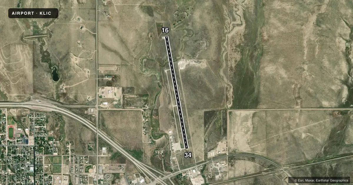
Airport sketch
Runways drawn to scale from FAA survey coordinates, rendered over satellite imagery. Not for navigation.
Approaches & charts
Services on the field
Fuel grades, oxygen, maintenance, ramp storage and lighting — as declared to the FAA by the airport operator.
Fuel & services
- Fuel
- 100LL
- Airframe repair
- Minor
- Power plant repair
- Minor
- Other services
- INSTR
Ramp & ground
- Transient storage
- Tie-down
- Landing fee
- No fee published
- Customs
- Not available
- Lighting schedule
- SEE RMK
- Beacon schedule
- SS-SR
- Beacon
- White / Green (civil land)(WG)
- Wind indicator
- Yes
- Segmented circle
- Yes
Fuel & FBOs
Cheapest 100LL and Jet A on the field and nearby. Always confirm with the FBO before taxi.
Airport notes
Surface conditions, obstructions, local procedures, lighting outages and other notes published with each FAA cycle.
General notes
- CTN: UNCTLD VEHICLE ACES.
- TWY MKD WITH BLUE REFLECTORS.
- DEER ON & INVOF ARPT.
- CTN: MIL STUDENT TRNG INVOF COLORADO SPRINGS & PUEBLO COLORADO.
- FOR CD IF UNA TO CTC ON FSS FREQ, CTC DENVER ARTCC AT 303-651-4257.
- PAJA ON & INVOF ARPT; MIDFIELD OVR FLT NA.
Lighting notes
- ACTVT PAPI RWY 16 & 34; MIRL RWY 16/34 - CTAF.
Fuel notes
- 100LLAVBL H24 WITH CREDIT CARD.
Runway surface & condition
- 16/343000 FT TWY LEADING TO S END OF RWY 16.
Approach & departure obstructions
- 34+18 FT ROAD 820 FT FM THR OB; +4 FT FENCE 785 FT FM THR OB; +22 FT SIGN 918 FT FM RWY END ON CNTRLN; +45 FT TREES 62 FT LT OF CTLN, 1430 FT FM RWY END OB; +51 FT TANK 1455 FT FM THR 150 R OF CNTRLN.
Other notes
- EST PRIOR TO 1959
VFR map & nearby airports
VFR sectional. Tap any ICAO chip to open that airport.
Key facts · KLIC
Answer card- ICAO
- KLIC
- Name
- LIMON MUNI
- Location
- LIMON, COLORADO
- Elevation
- 5,374.4 ft MSL
- Traffic pattern altitude
- 6,374.4 ft MSL (1,000 AGL)
- Control tower
- Non-towered (use CTAF)
- Total runways
- 1
- Longest runway
- 16/34 · 4,700 ft
- Published ILS approaches
- 0
- Published frequencies
- 1
- Magnetic variation
- 7°
- Current flight rules
- VFR
- Current wind
- 030° at 4 kt
- Favored runway now
- RWY 34
Limon Muni sits in Limon, Colorado. Field elevation is 5,374.4 ft MSL. The airport has one runway, 16/34, at 4,700 ft. It is an uncontrolled field with CTAF 122.9. No ILS approaches are published here. The pattern altitude is not published, so use standard 1,000 ft AGL unless the current Chart Supplement says otherwise.
The on-field FBO is Limon Municipal Airport. It carries AVGAS 100LL. Published remarks say 100LL is available 24 hours with credit card. That is useful for late arrivals or early departures. Runway lighting on 16 and 34 is medium intensity and controlled by CTAF. PAPI is also available for both ends.
First-time pilots should pay attention to the published hazards. There is uncontrolled vehicle access. Deer are on and near the airport. Paja is on and in the vicinity of the field, so midfield overflight is not authorized. There are also several noted obstructions near the runway ends. Taxiways are marked with blue reflectors. The field is established prior to 1959. Expect a high-plains environment with elevation to plan for. Check density altitude before departure. If you need clearance delivery and cannot reach Flight Service, contact Denver ARTCC at 303-651-4257.