METAR & TAF KFLY
Current METAR
Observed 03:15Z
KFLY 280315Z AUTO 34010G20KT 10SM VCTS BKN110 23/12 A3026 RMK AO2 LTG DSNT E SW AND W T02300123
- Wind
- 340° @ 10G20 kt
- Visibility
- 10 SM
- Temp / Dew
- 23°C / 12°C
- Altimeter
- 30.26 inHg
- Clouds
- BKN
- Density alt
- 9,067 ft
- Ceiling
- 11,000 ft AGL
- Rules
- VFR
Airport info & contacts
Manager on record, flight service, ARTCC, attendance schedule and pattern altitude — published by the FAA and refreshed every 28 days.
Location
- From city
- 14 NM NE
- VFR sectional
- DENVER
- ARTCC
- ZDV · DENVER
- NOTAM facility
- DEN (NOTAM-D)
Airport manager
- Name
- DAVE ELLIOTT
- Phone
- 719-339-0928
- Address
- 13625 JUDGE ORR ROAD, PEYTON CO 80831
Flight service · Hours
- FSS DEN
- DENVER1-800-WX-BRIEF
- Attendance
- 0800-1700
Frequencies
Tap any row to copy the frequency to your clipboard.
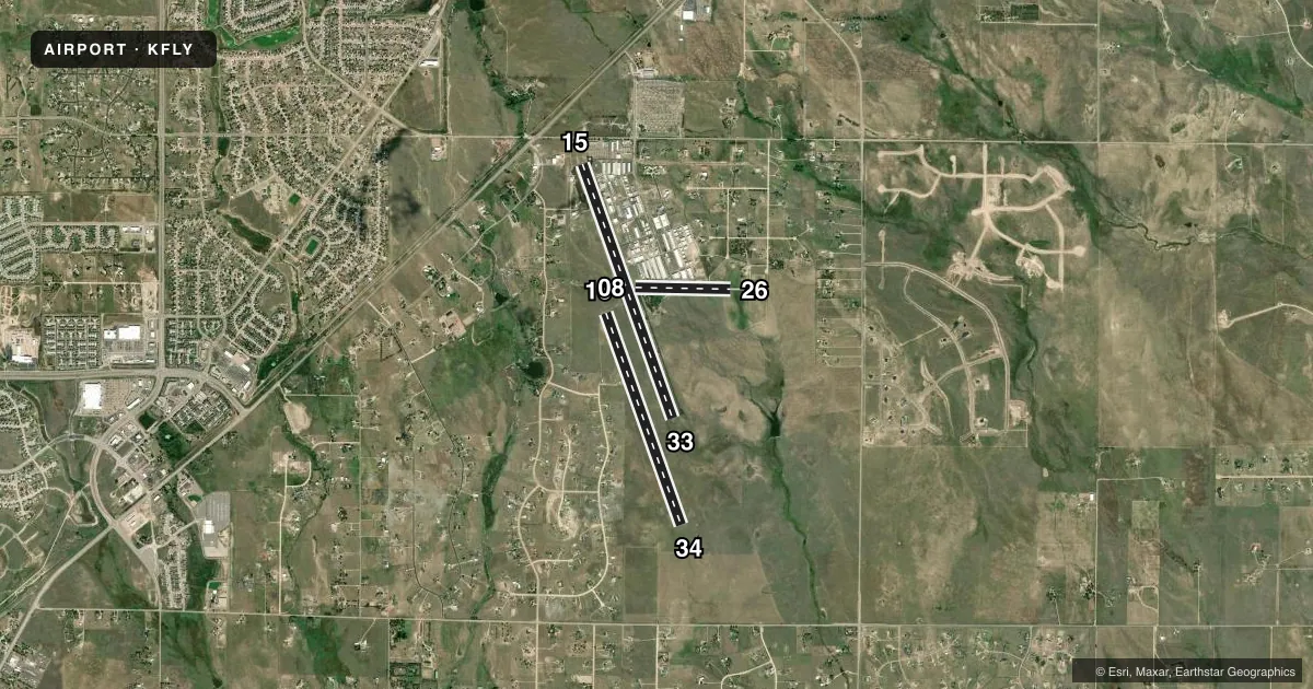
Runways & pattern
Full pagePattern entry · RWY 33
RIGHT TRAFFIC| Runway | Heading (°M) | Length | Surface | Traffic |
|---|---|---|---|---|
| 15/33Favored | 153° / 333° | 6,001 ft | ASPH | 33 R |
| 16/34 | 153° / 333° | 5,001 ft | TURF | Standard L |
| 08/26 | 84° / 264° | 2,126 ft | ASPH-GRVL | 08 R |
Runway end performance
| End | TORA | TODA | ASDA | LDA | VGSI | Approach lights | Obstruction |
|---|---|---|---|---|---|---|---|
| 15 | — | — | — | — | PAPI 2-box left(3.5°) | — | 18', road, 558' from thr, 115' R of cntrln, slope 19 |
| 33 | — | — | — | — | PAPI 2-box left(3°) | — | — |
| 16 | — | — | — | — | — | — | 7', berm, 72' from thr, 102' R of cntrln, slope 10 |
Declared distances in feet. TORA = takeoff run available, TODA = takeoff distance, ASDA = accelerate-stop, LDA = landing distance.
Airport sketch
Runways drawn to scale from FAA survey coordinates, rendered over satellite imagery. Not for navigation.
Approaches & charts
Services on the field
Fuel grades, oxygen, maintenance, ramp storage and lighting — as declared to the FAA by the airport operator.
Fuel & services
- Fuel
- 100LL
- Oxygen (bottled)
- Not available
- Oxygen (bulk)
- Low pressure
- Airframe repair
- Major
- Power plant repair
- Major
- Other services
- GLD,INSTR,RNTL,SALES,TOW
Ramp & ground
- Transient storage
- Tie-down
- Hangar
- Landing fee
- No fee published
- Lighting schedule
- SEE RMK
- Beacon schedule
- SS-SR
- Beacon
- White / Green (civil land)(WG)
- Wind indicator
- Lighted
- Segmented circle
- Yes
Fuel & FBOs
Cheapest 100LL and Jet A on the field and nearby. Always confirm with the FBO before taxi.
Airport notes
Surface conditions, obstructions, local procedures, lighting outages and other notes published with each FAA cycle.
General notes
- GLIDERS OPERATE ON 16/34 AND WEST SIDE OF ARPT.
- RWY 26; 4 FT TERRAIN 5 FT FM RWY EDGE FIRST 100 FT ON BOTH SIDES OF RWY.
- WILDLIFE ON AND INVOF OF AIRPORT.
- RWY 26; 4 FT FENCE 50 FT RIGHT OF CNTRLN 95 FT FM THLD.
- CTN: ; INTENSIVE USAF STUDENT TNG INVOF COLORADO SPRINGS & PUEBLO COLORADO.
- RWY 26: 15 FT ROAD EXTDS EAST FM THLD.
- CTN: PWRD PARAGLIDERS AND MOBILE AEROSTATS OPER SOUTHEAST SIDE OF ARPT SFC-500 FT.
- RWY 16/34 HAS EDGES AND THLDS MKD WITH WHITE TIRES.
- FOR CD CTC COLORADO SPRINGS APCH AT 719-556-9105.
- RWY 08/26 EDGES MKD WITH WHITE REFLECTORS AND TIRES.
Lighting notes
- ACTVT REIL RWY 15 & 33; ACTVT & INCR INTST MIRL RWY 15/33 - CTAF. PAPI RWY 15 & 33 ON CONSLY.
Fuel notes
- 100LL100LL AVBL 24 HRS SELF SVC CREDIT CARD.
Runway surface & condition
- 08/26RWY 08/26 1149 FT GRVL ON E END OF RWY, 925 FT ASPH ON W END OF RWY.
Other notes
- OWNERDAVE ELLIOTT ASSOCIATION PRESIDENT.
- MANAGERALTN PHONE IS MIKE BARR AT (719) 287-4204
VFR map & nearby airports
VFR sectional. Tap any ICAO chip to open that airport.
Key facts · KFLY
Answer card- ICAO
- KFLY
- Name
- MEADOW LAKE
- Location
- COLORADO SPRINGS, COLORADO
- Elevation
- 6,878.1 ft MSL
- Traffic pattern altitude
- 7,878.1 ft MSL (1,000 AGL)
- Control tower
- Non-towered (use CTAF)
- Total runways
- 3
- Longest runway
- 15/33 · 6,001 ft
- Published ILS approaches
- 0
- Published frequencies
- 4
- Magnetic variation
- 7°
- Current flight rules
- VFR
- Current wind
- 340° at 10 kt
- Favored runway now
- RWY 33
Meadow Lake Airport (KFLY) sits in Colorado Springs, Colorado. Field elevation is 6,878.1 ft MSL. The airport has three runways. The longest is runway 15/33 at 6,001 ft. It is asphalt. Runway 16/34 is 5,001 ft turf. Runway 08/26 is 2,126 ft asphalt-gravel.
There is no control tower. CTAF and UNICOM are both 122.7. The published pattern altitude is not listed, so use the standard 1,000 ft AGL for light piston traffic unless the current FAA Chart Supplement says otherwise. No ILS approaches are published. For clearance delivery, contact Colorado Springs Approach at 719-556-9105.
Phantom Fuel is on the field. It carries 100LL. Self-serve 100LL is available 24 hours with credit card. Runway 15/33 has runway end identifier lights. Its medium intensity lights increase on CTAF. Precision approach path indicators on 15 and 33 are on continuously.
First-time pilots should pay attention to the elevation. Performance will be different here than at lower fields. Watch for gliders on runway 16/34 and the west side of the airport. Also watch for powered paragliders and mobile aerostats on the southeast side up to 500 ft. Wildlife is reported on and near the airport. Runway 26 also has a fence near the threshold area and terrain close to the edge in the first 100 ft on both sides.