METAR & TAF 5V4
5V4 does not publish a METAR.
Showing the nearest reporting station: KFLY (MEADOW LAKE) · 14.4 NM away. Conditions at 5V4 may differ.
METAR · KFLY
Observed 14:55Z
KFLY 271455Z AUTO 35012G22KT 10SM -RA OVC110 23/09 A3028 RMK AO2 T02330090
- Wind
- 350° @ 12G22 kt
- Visibility
- 10 SM
- Temp / Dew
- 23°C / 9°C
- Altimeter
- 30.28 inHg
- Clouds
- OVC
- Density alt
- 8,512 ft
- Ceiling
- 11,000 ft AGL
- Rules
- VFR
Airport info & contacts
Manager on record, flight service, ARTCC, attendance schedule and pattern altitude — published by the FAA and refreshed every 28 days.
Location
- From city
- 1 NM N
- VFR sectional
- DENVER
- Pattern altitude
- 800 ft AGL · 7,250 ft MSL
- ARTCC
- ZDV · DENVER
- NOTAM facility
- DEN (NOTAM-D)
Airport manager
- Name
- DAVID E GLASER
- Phone
- 719-338-2149
- Address
- PO BOX 69, CALHAN CO 80808
Flight service · Hours
- FSS DEN
- DENVER1-800-WX-BRIEF
- Attendance
- IREG
Frequencies
Tap any row to copy the frequency to your clipboard.
Runways & pattern
Full pagePattern entry · RWY 35
RIGHT TRAFFICRunway end performance
| End | TORA | TODA | ASDA | LDA | VGSI | Approach lights | Obstruction |
|---|---|---|---|---|---|---|---|
| 17 | — | — | — | — | TRIL | — | 22', pole, 432' from thr, 96' R of cntrln, slope 19 |
| 35 | — | — | — | — | — | — | 35', trees, 116' from thr, 53' R of cntrln, slope 3 |
Declared distances in feet. TORA = takeoff run available, TODA = takeoff distance, ASDA = accelerate-stop, LDA = landing distance.
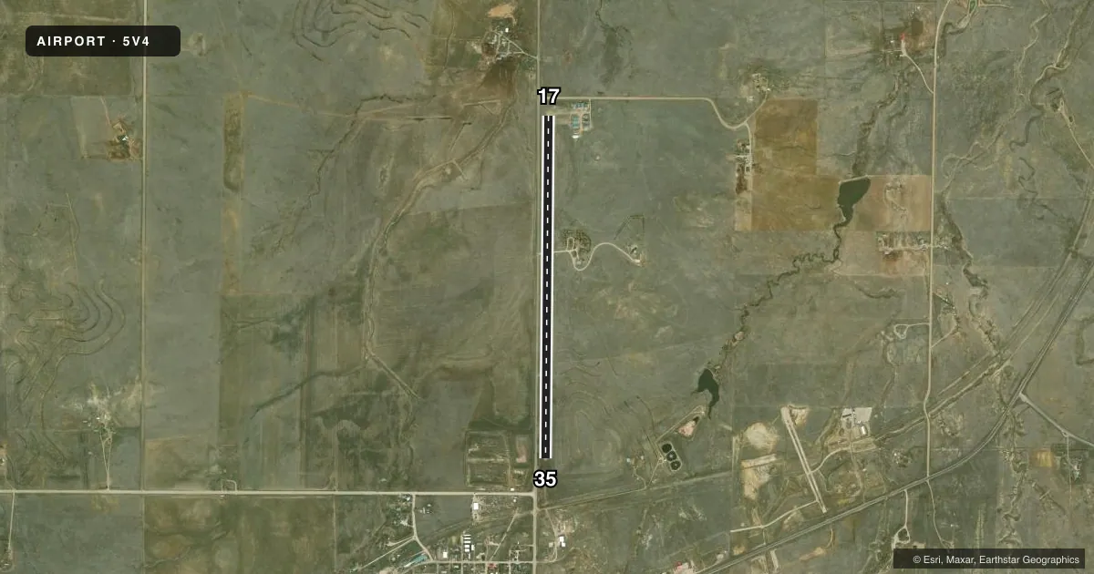
Airport sketch
Runways drawn to scale from FAA survey coordinates, rendered over satellite imagery. Not for navigation.
Approaches & charts
Services on the field
Fuel grades, oxygen, maintenance, ramp storage and lighting — as declared to the FAA by the airport operator.
Fuel & services
- Fuel
- Not available
- Oxygen (bottled)
- Not available
- Oxygen (bulk)
- Not available
- Airframe repair
- Not available
- Power plant repair
- Not available
Ramp & ground
- Transient storage
- Tie-down
- Hangar
- Landing fee
- No fee published
- Lighting schedule
- SEE RMK
- Wind indicator
- Lighted
- Segmented circle
- Yes
Fuel & FBOs
Cheapest 100LL and Jet A on the field and nearby. Always confirm with the FBO before taxi.
Airport notes
Surface conditions, obstructions, local procedures, lighting outages and other notes published with each FAA cycle.
General notes
- S END OF RY HAS SIDE SLOPE. -6 FT DITCH 40 FT W OF CNTRLN. GROUND RISES ON EAST SIDE OF RY.
- AEROBATIC PRACTICE AREA ONE-HALF MILE W OF RY 17/35 300 FT AGL TO 10000 FT MSL.
- VEHICLES CROSSING RY.
- RWY 17 HAS 25 FT P-POLE 400 FT FM THLD, 110 FT R OF CNTRLN.
- BE ALERT; INTENSIVE USAF STUDENT TRAINING IN VICINITY OF COLORADO SPRINGS & PUEBLO COLORADO.
- RY 17/35 HAS +15 FT ROAD 110 FT FM & PARALLEL TO RY CNTRLN W SIDE OF RY - FULL LENGTH.
- RWY 35 HAS 4 FT FENCE 200 FT FM THLD OB; APPX 20 FT TREES 70 FT WEST OF CNTRLN FOR FIRST 500 FT OF RWY; APPX 25 FT P-LINE 850 FT FM THLD OB; APPX 2 FT BURM AT RWY THLD.
- FOR CD CTC COLORADO SPRINGS APCH AT 719-556-9105.
Lighting notes
- DUSK-DAWN. ACTVT NSTD LIRL RY 17/35 & VASI RY 17 - CTAF.
Runway surface & condition
- 17/35RY 17/35 NSTD LIRL. NORTH 3000 FT RY LIGHTED.
- 17/35WIDTH VARIES FM 50 FT TO 100 FT.
Other notes
- PROVIDED A NON-STD RIGHT-HAND TFC PAT IS CONDUCTED TO RWY 35.
- MANAGERALTERNATE NUMBER 719-347-2338
- 17/35RY 17 FIRST 1250 FT 45 FT WIDE ARTIFICIAL TURF.
VFR map & nearby airports
VFR sectional. Tap any ICAO chip to open that airport.
Key facts · 5V4
Answer card- ICAO
- 5V4
- Name
- CALHAN
- Location
- CALHAN, COLORADO
- Elevation
- 6,450 ft MSL
- Traffic pattern altitude
- 7,250 ft MSL (800 AGL)
- Control tower
- Non-towered (use CTAF)
- Total runways
- 1
- Longest runway
- 17/35 · 4,565 ft
- Published ILS approaches
- 0
- Published frequencies
- 2
- Magnetic variation
- 11°
- Current flight rules
- VFR
- Current wind
- 350° at 12 kt
- Favored runway now
- RWY 35
Calhan Airport (5V4) sits in Calhan, Colorado. The field elevation is 6,450 ft MSL. It has one runway. Runway 17/35 is 4,565 ft long and surfaced turf-gravel. The longest runway is 4,565 ft. There is no control tower. CTAF and UNICOM are both 122.725.
Pattern altitude is 800 ft AGL, which is 7,250 ft MSL. No ILS approaches are published. The airport is in a high-elevation part of Colorado, so density altitude will matter on warm days. Check performance before departure.
Published remarks show several items a first-time pilot should plan for. Runway 35 uses a non-standard right-hand traffic pattern. Low-intensity runway lighting is available from dusk to dawn. The VASI on runway 17 is activated by CTAF. Be alert for intensive Air Force student training in the Colorado Springs and Pueblo area. There is also an aerobatic practice area one-half mile west of runway 17/35 from 300 ft AGL to 10,000 ft MSL.
There are no on-field FBOs listed. Contact the airport operator directly or call the field on CTAF for current service details. The published remarks also note runway-side obstructions, a road near the runway and vehicles crossing the runway. Treat this as a close-in, low-margin field and brief your approach before you get there.