METAR & TAF KAFO
Current METAR
Observed 06:35Z
KAFO 270635Z AUTO 00000KT 10SM CLR 15/08 A3019 RMK AO2
- Wind
- 000° @ 0 kt
- Visibility
- 10 SM
- Temp / Dew
- 15°C / 8°C
- Altimeter
- 30.19 inHg
- Clouds
- CLR
- Density alt
- 7,379 ft
- Ceiling
- Unlimited
- Rules
- VFR
Airport info & contacts
Manager on record, flight service, ARTCC, attendance schedule and pattern altitude — published by the FAA and refreshed every 28 days.
Location
- From city
- 1 NM SW
- VFR sectional
- SALT LAKE CITY
- ARTCC
- ZLC · SALT LAKE CITY
- NOTAM facility
- CPR (NOTAM-D)
Airport manager
- Name
- HEATH LAWSON
- Phone
- 307-885-3245
- Address
- BOX 1181, AFTON WY 83110
Flight service · Hours
- FSS CPR
- CASPER1-800-WX-BRIEF
- Attendance
- MON-FRI · 0700-1600
- MAY-SEPT · SAT · 0800-1200
Frequencies
Tap any row to copy the frequency to your clipboard.
Runways & pattern
Full pagePattern entry · RWY 16
RIGHT TRAFFICRunway end performance
| End | TORA | TODA | ASDA | LDA | VGSI | Approach lights | Obstruction |
|---|---|---|---|---|---|---|---|
| 16 | — | — | — | — | PAPI 4-box left(3.5°) | — | 51', pole, 1290' from thr, 278' R of cntrln, slope 21 |
| 34 | — | — | — | — | PAPI 4-box left(3.5°) | — | 90', tree, 2014' from thr, 185' R of cntrln, slope 19 |
Declared distances in feet. TORA = takeoff run available, TODA = takeoff distance, ASDA = accelerate-stop, LDA = landing distance.
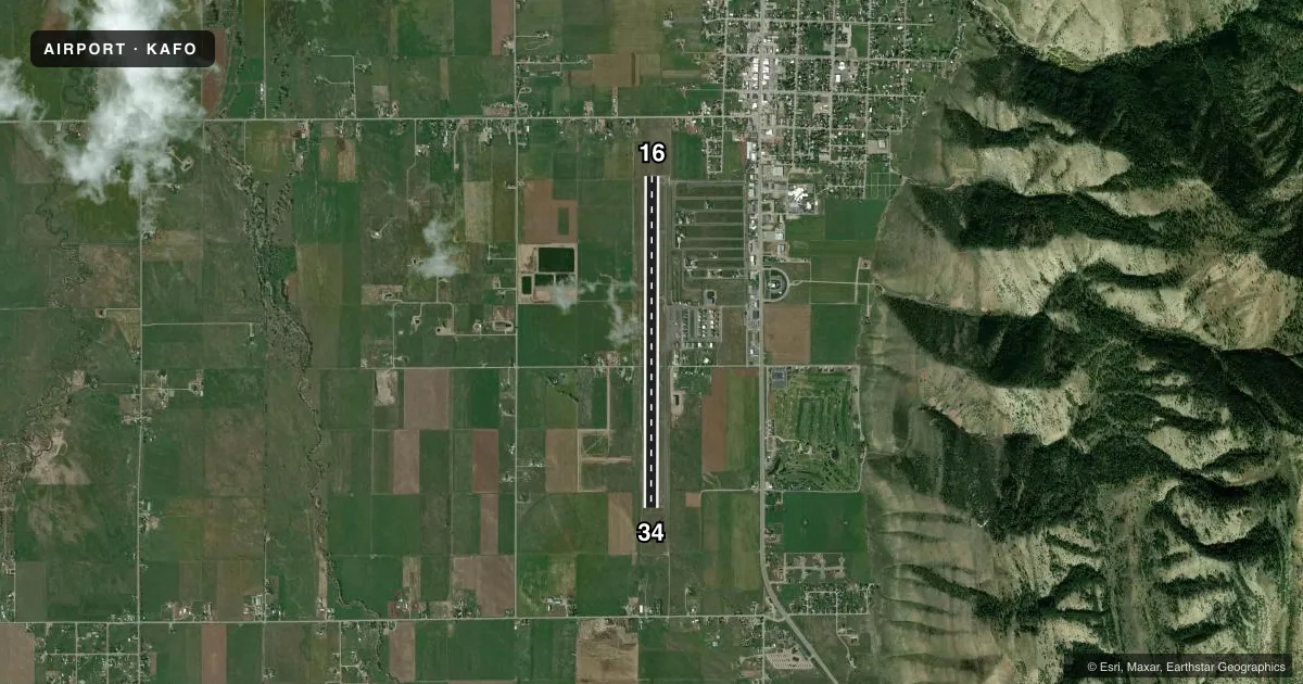
Airport sketch
Runways drawn to scale from FAA survey coordinates, rendered over satellite imagery. Not for navigation.
Approaches & charts
Services on the field
Fuel grades, oxygen, maintenance, ramp storage and lighting — as declared to the FAA by the airport operator.
Fuel & services
- Fuel
- 100LLA
- Oxygen (bottled)
- Not available
- Oxygen (bulk)
- Low pressure
- Airframe repair
- Major
- Power plant repair
- Major
- Other services
- INSTR,RNTL
Ramp & ground
- Transient storage
- Tie-down
- Hangar
- Landing fee
- Yes
- Customs
- Not available
- Lighting schedule
- SEE RMK
- Beacon schedule
- SS-SR
- Beacon
- White / Green (civil land)(WG)
- Wind indicator
- Lighted
- Segmented circle
- Yes
Fuel & FBOs
Cheapest 100LL and Jet A on the field and nearby. Always confirm with the FBO before taxi.
Airport notes
Surface conditions, obstructions, local procedures, lighting outages and other notes published with each FAA cycle.
General notes
- SNBNKS 4 FT TO 7 FT ALG RWYS & TXYS EDGES FM NOV-APR WITH SLICK SPOTS ALL SFCS.
- COLD TEMPERATURE AIRPORT. ALTITUDE CORRECTION REQUIRED AT OR BELOW -18C.
- FOR CD CTC SALT LAKE ARTCC AT 801-320-2568.
- WILDLIFE ON & INVOF ARPT.
Lighting notes
- ACTVT REIL RWY 16 & 34; MIRL RWY 16/34 - CTAF. PAPI RWY 16 & 34 OPR CONSLY.
Fuel notes
- 100LLAVBL H24 SELF SVC VIA CREDIT CARD. FULL SERVICE AVBL WITH CALL OUT 307-885-7030.
- AFUEL 24 HR CREDIT CARD SVC; FULL SVC JET AVBL WITH CALLOUT 307-8881485.
Approach & departure obstructions
- 34RWY 34 PAPI DOES NOT PRVD OBST CLNC BYD 5.0 NM FM THR, UNUSBL BYD 5.0 NM.
Other notes
- PILOT SUPD ROPES RQRD.
- OWNERALSO LINCOLN COUNTY-307-877-2004.
VFR map & nearby airports
VFR sectional. Tap any ICAO chip to open that airport.
Key facts · KAFO
Answer card- ICAO
- KAFO
- Name
- AFTON LINCOLN COUNTY/GENERAL BOYD L EDDINS FLD
- Location
- AFTON, WYOMING
- Elevation
- 6,220.9 ft MSL
- Traffic pattern altitude
- 7,220.9 ft MSL (1,000 AGL)
- Control tower
- Non-towered (use CTAF)
- Total runways
- 1
- Longest runway
- 16/34 · 7,025 ft
- Published ILS approaches
- 0
- Published frequencies
- 2
- Magnetic variation
- 14°
- Current flight rules
- VFR
- Current wind
- 000° at 0 kt
- Favored runway now
- –
Afton Lincoln County/General Boyd L Eddins Fld sits in Afton, Wyoming. The field elevation is 6,220.9 ft MSL. It has one runway. Runway 16/34 is 7,025 ft long with asphalt surface. There is no control tower. CTAF and UNICOM are both 122.8. No ILS approaches are published.
Pattern altitude is not published. Use the standard 1,000 ft AGL pattern for light piston traffic unless the current Chart Supplement says otherwise. The airport is high elevation. Expect performance planning to matter. Cold weather is also a factor here. The published remarks say altitude correction is required at or below minus 18 degrees Celsius. Snowbanks can run 4 ft to 7 ft along runway and taxiway edges from November through April. Slick spots can be present on all surfaces.
Eagle Flight Services is on the field. It carries 100LL and Jet A. 100LL is available 24 hours self-serve by credit card. Jet fuel is also available with callout. Runway 16 and 34 have runway end identifier lights. The runway lights are medium intensity on CTAF. PAPI operates continuously on both ends. Wildlife has been reported on and near the airport. Runway 34 PAPI does not provide obstacle clearance beyond 5 NM from the threshold. Pilot supplied ropes are required. For clearance delivery, contact Salt Lake ARTCC before departure.