METAR & TAF 46U
Current METAR
Observed 10:15Z
K46U 271015Z AUTO 02005G10KT 10SM FEW010 SCT045 BKN065 19/12 A3021 RMK A01
- Wind
- 020° @ 5G10 kt
- Visibility
- 10 SM
- Temp / Dew
- 19°C / 12°C
- Altimeter
- 30.21 inHg
- Clouds
- BKN
- Density alt
- 7,110 ft
- Ceiling
- 6,500 ft AGL
- Rules
- VFR
Airport info & contacts
Manager on record, flight service, ARTCC, attendance schedule and pattern altitude — published by the FAA and refreshed every 28 days.
Location
- From city
- 1 NM NW
- VFR sectional
- SALT LAKE CITY
- ARTCC
- ZLC · SALT LAKE CITY
- NOTAM facility
- CPR (NOTAM-D)
Airport manager
- Name
- ISAAC MILLER
- Phone
- 307-699-0085
- Address
- 810 OLD ALPINE ROAD, ALPINE WY 83128
Flight service · Hours
- FSS CPR
- CASPER1-800-WX-BRIEF
- Attendance
- Unattended
Frequencies
Tap any row to copy the frequency to your clipboard.
Runways & pattern
Full pagePattern entry · RWY 31
LEFT TRAFFICRunway end performance
| End | TORA | TODA | ASDA | LDA | VGSI | Approach lights | Obstruction |
|---|---|---|---|---|---|---|---|
| 13 | — | — | — | — | PAPI 2-box left(3°) | — | — |
| 31 | — | — | — | — | — | — | 19', road, 200' from thr, 0' R of cntrln, slope 1 |
Declared distances in feet. TORA = takeoff run available, TODA = takeoff distance, ASDA = accelerate-stop, LDA = landing distance.
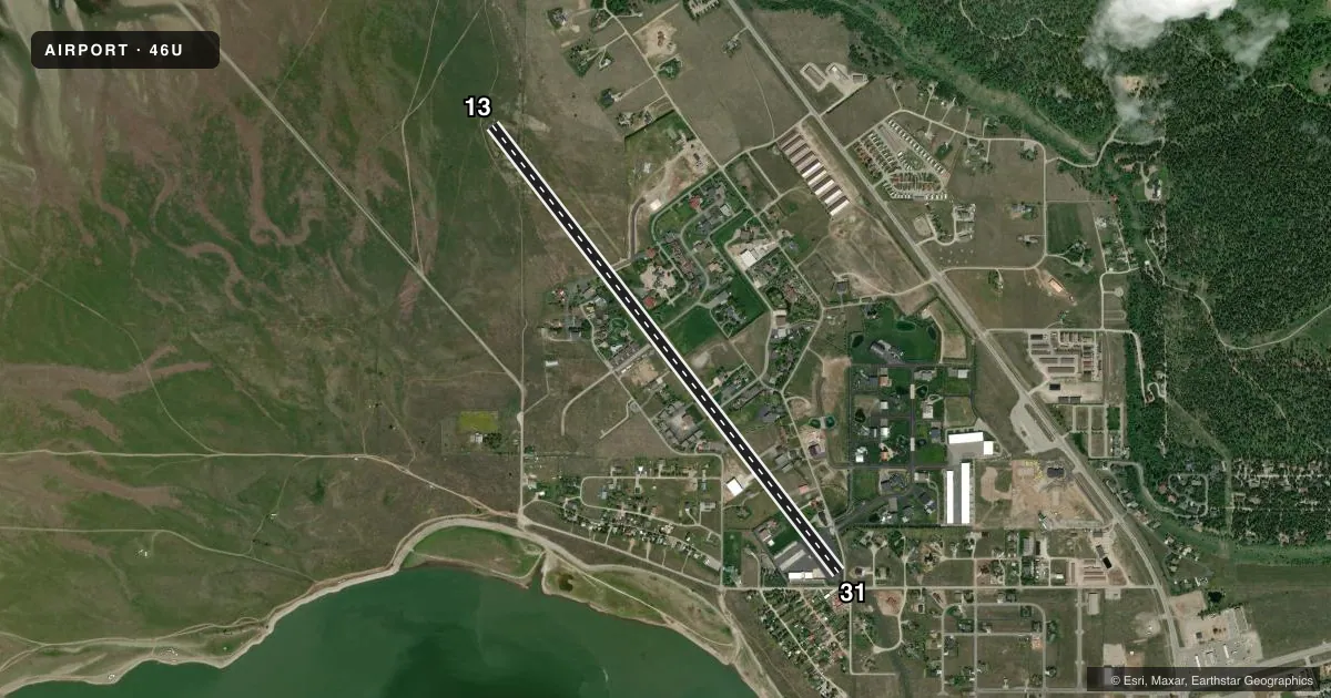
Airport sketch
Runways drawn to scale from FAA survey coordinates, rendered over satellite imagery. Not for navigation.
Approaches & charts
Services on the field
Fuel grades, oxygen, maintenance, ramp storage and lighting — as declared to the FAA by the airport operator.
Fuel & services
- Fuel
- 100LLA
- Oxygen (bottled)
- Not available
- Oxygen (bulk)
- Not available
- Airframe repair
- Not available
- Power plant repair
- Not available
Ramp & ground
- Transient storage
- Tie-down
- Landing fee
- Yes
- Customs
- Not available
- Lighting schedule
- SEE RMK
- Wind indicator
- Yes
- Segmented circle
- No
Fuel & FBOs
Cheapest 100LL and Jet A on the field and nearby. Always confirm with the FBO before taxi.
Airport notes
Surface conditions, obstructions, local procedures, lighting outages and other notes published with each FAA cycle.
General notes
- ARPT CLSD NGTS
- VOLUNTARY CURFEW DUSK TO DAWN. NGT LDGS LMTD TO AIRPARK RESIDENTS ONLY. NGT TIME LDGS AND TKFS NOT ADVS TO PILOTS UNFAMILIAR WITH TRRN. WILDLIFE ON AND INVOF OF ARPT. BIRD/WATERFOWL HAZ.
- FOR RWY COND IN WINTER CTC - AMGR.
- VRB RWY COND AND BA WINTER MOS. SNBNK ALG RWY & TWY EDGES POSS FALL, WINT, SPRING MOS. TREACHEROUS MTN TERR IN CLOSE PROXIMITY ALL QUADS OF RWY.
- AVOID LOW LEVEL FLT OVER CITY OR EAST OF RWY,
- NOISE SENS ARPT WX PMTG LND RWY 13 TKOF RWY 31 FOR NOISE ABATEMENT; DUE TO THE PROXIMITY OF THE TOWN OF ALPINE & ARPT HOUSING; TOUCH & GOES ARE PROHIBITED.
- RESIDENTIAL TWYS ESTAB THEIR OWN WT LMTS & RQR APVL PRIOR TO USE.
- FOR CD CTC SALT LAKE ARTCC AT 801-320-2568.
- TSNT TFC MUST CTC THE AMGR FOR INFO ON UNIQUE LCL FLYING OPNS BFR USING THE ARPT.
Lighting notes
- ACTVT PAPI RWY 13; MIRL RWY 13/31 - CTAF
Fuel notes
- A24 HR SELF SVC FUEL AVBL WITH CREDIT CARD; FULL SVC JET A & AVGAS ALSO AVBL ARNGD IN ADVN PHONE 307-654-4646.
Approach & departure obstructions
- 13+3 FT VEGETATION & +5 FT DROP 60 FT FROM RWY END ACRS BOTH SIDES OF CNTRLN.
- 3116 FT PAVED ROAD 106 FT FM RWY END CROSSES RWY END.
- 31RWY 13/31 FENCES, BLDGS & TREES WI 150 FT N & S OF CNTRLN.
- 31RWY 31 FM DSPLCD THLD 20:1 TO 45 FT TREE 480 FT EOR 75 FT L.
Other notes
- FEES IMPOSED FOR LDG OVNGT OR EXTDD STAY PRKG. RAMP & PRKG SPACE VERY LTD SPCLY IN THE WINTER.
- PRKG FEES BASED ON SIZE OF ACFT WILL APPLY.
VFR map & nearby airports
VFR sectional. Tap any ICAO chip to open that airport.
Key facts · 46U
Answer card- ICAO
- 46U
- Name
- ALPINE
- Location
- ALPINE, WYOMING
- Elevation
- 5,637 ft MSL
- Traffic pattern altitude
- 6,637 ft MSL (1,000 AGL)
- Control tower
- Non-towered (use CTAF)
- Total runways
- 1
- Longest runway
- 13/31 · 5,827 ft
- Published ILS approaches
- 0
- Published frequencies
- 1
- Magnetic variation
- 11°
- Current flight rules
- VFR
- Current wind
- 020° at 5 kt
- Favored runway now
- RWY 31
Alpine Airport sits in Alpine, Wyoming. The field elevation is 5,637 ft MSL. It has one runway. Runway 13/31 is 5,827 ft long, which is the longest runway on the field. There is no control tower. CTAF is 122.9. No ILS approaches are published.
The published pattern altitude is not listed. Use the standard 1,000 ft AGL for light piston traffic unless the current FAA Chart Supplement says otherwise. Alpine Airpark is on the field. It carries 100LL and Jet A. Call 307-654-4646 for full-service fuel or to confirm current airport details before arrival.
This is a noise-sensitive airport. The published recommendation is to land on Runway 13 and depart Runway 31. Touch-and-goes are prohibited. The airport is closed at night. Night landings are limited to Airpark residents only. The field also has winter braking and runway condition issues, plus mountain terrain close in all quadrants. That matters here. Plan your arrival with extra care, especially if you are new to the area. There are also published obstructions near both runway ends, so review the current Chart Supplement before you go.