METAR & TAF KJAC
Current METAR
Observed 10:56Z
KJAC 271056Z AUTO 17022KT 6SM VCTS RA FEW045 BKN070 OVC110 17/13 A3027 RMK AO2 PK WND 18028/1044 WSHFT 1026 LTG DSNT NW-E TSB19RAB27 SLP172 P0009 T01670128
- Wind
- 170° @ 22 kt
- Visibility
- 6 SM
- Temp / Dew
- 17°C / 13°C
- Altimeter
- 30.27 inHg
- Clouds
- OVC
- Density alt
- 7,806 ft
- Ceiling
- 7,000 ft AGL
- Rules
- VFR
Airport info & contacts
Manager on record, flight service, ARTCC, attendance schedule and pattern altitude — published by the FAA and refreshed every 28 days.
Location
- From city
- 7 NM N
- VFR sectional
- SALT LAKE CITY
- ARTCC
- ZLC · SALT LAKE CITY
- NOTAM facility
- JAC (NOTAM-D)
Airport manager
- Name
- JIM ELWOOD
- Phone
- (307) 733-7695
- Address
- P. O. BOX 159, JACKSON WY 83001
Flight service · Hours
- FSS CPR
- CASPER1-800-WX-BRIEF
- Attendance
- 0700-2130
Frequencies
Tap any row to copy the frequency to your clipboard.
Runways & pattern
Full pagePattern entry · RWY 19
LEFT TRAFFICRunway end performance
| End | TORA | TODA | ASDA | LDA | VGSI | Approach lights | Obstruction |
|---|---|---|---|---|---|---|---|
| 01 | 6,300' | 6,300' | 6,300' | 6,300' | PAPI 4-box left(3°) | MALS | 10', road, 249' from thr, 505' R of cntrln, slope 5 |
| 19 | 6,300' | 6,300' | 6,300' | 6,300' | PAPI 4-box right(3°) | MALS | — |
Declared distances in feet. TORA = takeoff run available, TODA = takeoff distance, ASDA = accelerate-stop, LDA = landing distance.
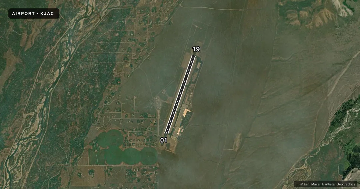
Airport sketch
Runways drawn to scale from FAA survey coordinates, rendered over satellite imagery. Not for navigation.
Approaches & charts
ILS · 1
Services on the field
Fuel grades, oxygen, maintenance, ramp storage and lighting — as declared to the FAA by the airport operator.
Fuel & services
- Fuel
- 100LLA
- Oxygen (bottled)
- High pressure
- Oxygen (bulk)
- Not available
- Airframe repair
- Minor
- Power plant repair
- Minor
- Other services
- AFRT,AMB,CHTR,INSTR,RNTL
Ramp & ground
- Transient storage
- Tie-down
- Hangar
- Landing fee
- Yes
- Customs
- Not available
- Lighting schedule
- SEE RMK
- Beacon schedule
- SS-SR
- Beacon
- White / Green (civil land)(WG)
- Wind indicator
- Lighted
- Segmented circle
- No
Fuel & FBOs
Cheapest 100LL and Jet A on the field and nearby. Always confirm with the FBO before taxi.
Airport notes
Surface conditions, obstructions, local procedures, lighting outages and other notes published with each FAA cycle.
General notes
- 35'-53' TREES 700'-800' WEST OF THR RY 01.
- NOISE ABATEMENT PROCEDURES IN EFFECT FOR ACFT DEPARTURES ON RWY 19.
- SAGE GROUSE ON & INVOF ARPT APR THRU OCT.
- POSSIBLE SEVERE WINTER CONDITIONS FROM NOV-APR; NO ARPT INFO OR SNOW REMOVAL GUARANTEED DURING HOURS OF NON ATTENDANCE. 307-733-7682
- HANG GLIDING OPNS 9 MILES S OF ARPT NEAR SKI ARE & 9 MILES SSW OF ARPT ALONG THE RIDGE.
- BALLOON OPERATIONS IN VICINITY OF AIRPORT, W AND SW, MAY-OCT.
- FOR PUBLIC HEALTH & SAFETY FLIGHTS, CONTACT AMGR @ 307-733-7682.
- ACFT THAT FAIL TO TOUCH DOWN WITHIN THE FIRST THIRD OF RY 01/19 SOMETIMES FAIL TO STOP ON THE RY AND ARE AT RISK FOR A RY EXCURSION.
- PAVED 950X200 FT SAFETY AREA AT THE DEP END OF RWY 19; NOT USBL FOR PER CALCULATIONS; PLOWED & BROOMED DURG WINTER.
- DEICING PAD LOCATED AT NORTH END OF TWY A.
- COLD TEMPERATURE AIRPORT. ALTITUDE CORRECTION REQUIRED AT OR BELOW -21C.
- FOR CD IF UNA TO CTC ON FSS FREQ, CTC JAC TWR GND AT 124.55 DURG NML OPRG HRS. OUTSIDE OF NML OPRG HRS, CTC SALT LAKE ARTCC AT 801-320-2568.
- ACFT PUSHING BACK FM TRML CAUSE CGSTN, MAKING A2 UNAVBL. COORD RWY EXITS WITH TWR.
- ALL MOVEMENT AREA SFCS AVBL FOR AIR CARRIER OPS.
Lighting notes
- WHEN ATCT CLSD ACTVT MALS RWY 01 & 19; HIRL RWY 01/19; RCLS RWY 01/19; TWY LGTS; WDI - CTAF.
Runway surface & condition
- 01/19PCR VALUE: 508/F/C/X/T
Other notes
- OWNERLEASED FROM U S PARK SERVICE.
VFR map & nearby airports
VFR sectional. Tap any ICAO chip to open that airport.
Key facts · KJAC
Answer card- ICAO
- KJAC
- Name
- JACKSON HOLE
- Location
- JACKSON, WYOMING
- Elevation
- 6,451.3 ft MSL
- Traffic pattern altitude
- 7,451.3 ft MSL (1,000 AGL)
- Control tower
- Towered · 0700-2130
- Total runways
- 1
- Longest runway
- 01/19 · 6,300 ft
- Published ILS approaches
- 1
- Published frequencies
- 5
- Magnetic variation
- 13°
- Current flight rules
- VFR
- Current wind
- 170° at 22 kt
- Favored runway now
- RWY 19
Jackson Hole Airport sits in Jackson, Wyoming. The field elevation is 6,451.3 ft MSL. It has one runway, 01/19, which is 6,300 ft asphalt. The airport is towered. Tower hours are 0700-2130. There is one ILS approach. It serves runway 19. Pattern altitude is not published. Use 1,000 ft AGL for light piston traffic unless the current Chart Supplement says otherwise.
Jackson Hole Flight Services is on the field. It carries AVGAS_100LL, JET_A and JET_A_PRIST. The airport is a cold temperature field. Altitude correction is required at or below minus 21 degrees Celsius. Noise abatement procedures are in effect for departures on runway 19. There are 35-foot to 53-foot trees 700 to 800 feet west of the threshold of runway 01. The pavement classification rating is 508/F/C/X/T.
This is a high-elevation mountain airport, so performance planning matters. Expect density altitude to be a real factor in warm weather. The airport also has a paved safety area beyond the departure end of runway 19. It is not usable for performance calculations. When the tower is closed, use the published lighting activation procedures on CTAF. Check the current Chart Supplement for any additional operating notes before you go.