METAR & TAF KDIJ
Current METAR
Observed 04:56Z
KDIJ 270456Z AUTO 00000KT 10SM CLR 19/13 A3021 RMK AO2 SLP141 T01940133
- Wind
- 000° @ 0 kt
- Visibility
- 10 SM
- Temp / Dew
- 19°C / 13°C
- Altimeter
- 30.21 inHg
- Clouds
- CLR
- Density alt
- 7,879 ft
- Ceiling
- Unlimited
- Rules
- VFR
Airport info & contacts
Manager on record, flight service, ARTCC, attendance schedule and pattern altitude — published by the FAA and refreshed every 28 days.
Location
- From city
- 1 NM N
- VFR sectional
- SALT LAKE CITY
- ARTCC
- ZLC · SALT LAKE CITY
- NOTAM facility
- DIJ (NOTAM-D)
Airport manager
- Name
- BILLY CYR
- Phone
- 607-341-8041
- Address
- 60 S MAIN ST, DRIGGS ID 83422
Flight service · Hours
- FSS BOI
- BOISE1-800-WX-BRIEF
- Attendance
- OCT-MAY · 0800-1700
- JUN-SEP · 0700-1900
Frequencies
Tap any row to copy the frequency to your clipboard.
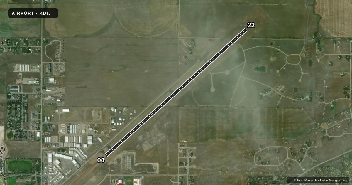
Runways & pattern
Full pagePattern entry · RWY 04
LEFT TRAFFICRunway end performance
| End | TORA | TODA | ASDA | LDA | VGSI | Approach lights | Obstruction |
|---|---|---|---|---|---|---|---|
| 04 | — | — | — | — | PAPI 4-box right(3.5°) | — | — |
| 22 | — | — | — | — | PAPI 4-box left(3.5°) | — | — |
Declared distances in feet. TORA = takeoff run available, TODA = takeoff distance, ASDA = accelerate-stop, LDA = landing distance.
Airport sketch
Runways drawn to scale from FAA survey coordinates, rendered over satellite imagery. Not for navigation.
Approaches & charts
Services on the field
Fuel grades, oxygen, maintenance, ramp storage and lighting — as declared to the FAA by the airport operator.
Fuel & services
- Fuel
- 100LLA+
- Oxygen (bulk)
- HIGH/LOW
- Airframe repair
- Minor
- Power plant repair
- Major
- Other services
- AMB,CHTR,GLD,INSTR,RNTL,TOW
Ramp & ground
- Transient storage
- Tie-down
- Hangar
- Landing fee
- Yes
- Customs
- Not available
- Lighting schedule
- SEE RMK
- Beacon schedule
- SS-SR
- Beacon
- White / Green (civil land)(WG)
- Wind indicator
- Lighted
- Segmented circle
- Yes
Fuel & FBOs
Cheapest 100LL and Jet A on the field and nearby. Always confirm with the FBO before taxi.
Airport notes
Surface conditions, obstructions, local procedures, lighting outages and other notes published with each FAA cycle.
General notes
- SAILPLANE OPNS DRG SUMMER MONTHS.
- 3000 FT X 150 FT TURF LDG AREA MKD WITH W CONES BTN RWY 04/22 AND TWY LTD TO TAILWHEEL ACFT WITH WINGSPAN 49 FT OR LESS.
- FOR CD CTC SALT LAKE ARTCC AT 801-320-2568.
- CALM WIND LNDG RWY 04.
- HEL NO HOVER TAXI.
- SVR WINTER CONDS PSBL NOV-APR. NO ARPT INFO OR SNOW REMOVAL GUARANTEED OUTSIDE NML BUS HRS.
- FBO PHONE 208-354-3100.
Lighting notes
- ACTVT REILS RWY 04 & 22; MIRLS RWY 04/22 - CTAF. PAPI RWYS 04 & 22 OPERS CONSLY.
Approach & departure obstructions
- 22PAPI UNUSBL BYD 4 NM DUE TO TRRN.
Other notes
- ESTABD PRIOR TO 15 MAY 1959.
- PWRD ACFT USE R TFC TO RWY 22. GLD UTILIZE R TFC FOR RWY 04 AND L TFC FOR 22.
- MANAGEREMAIL: BCYR@DRIGGSIDAHO.ORG
- AMBAIR METHODS ONSITE
VFR map & nearby airports
VFR sectional. Tap any ICAO chip to open that airport.
Key facts · KDIJ
Answer card- ICAO
- KDIJ
- Name
- DRIGGS/REED MEML
- Location
- DRIGGS, IDAHO
- Elevation
- 6,257 ft MSL
- Traffic pattern altitude
- 7,257 ft MSL (1,000 AGL)
- Control tower
- Non-towered (use CTAF)
- Total runways
- 1
- Longest runway
- 04/22 · 7,301 ft
- Published ILS approaches
- 0
- Published frequencies
- 2
- Magnetic variation
- 12°
- Current flight rules
- VFR
- Current wind
- 000° at 0 kt
- Favored runway now
- –
Driggs/Reed Memorial Airport sits in Driggs, Idaho. The field elevation is 6,257.2 ft MSL. It has one runway, 04/22, which is 7,301 ft long. There is no control tower. CTAF and UNICOM are both 122.7. No ILS approaches are published. The pattern altitude is not published, so use the standard 1,000 ft AGL for light piston operations unless the current Chart Supplement says otherwise.
Teton Aviation Center is on the field. It carries 100LL, Jet A and Jet A Prist. Air Methods is also onsite. The published remarks matter here. Auxiliary power units are restricted to the thirty minutes before planned departure. Longer use can trigger a charge. Helicopter no-hover taxi is noted. Sailplane activity is heavy in summer. The runway lighting is CTAF-controlled. PAPI is continuous on both runway ends. The runway 22 PAPI is unusable beyond 4 NM because of terrain.
This is a high-elevation airport, so performance planning matters. The field is in a mountain setting near Driggs. Expect density altitude to be a real factor on warm days. Calm wind landing is runway 22. For clearance delivery, contact Salt Lake ARTCC. If you need any operational detail beyond the published remarks, check the current FAA Chart Supplement or call the airport operator or the FBO directly by phone.