METAR & TAF U53
U53 does not publish a METAR.
Showing the nearest reporting station: KWYS (YELLOWSTONE) · 10.1 NM away. Conditions at U53 may differ.
METAR · KWYS
Observed 09:15Z
KWYS 270915Z AUTO 00000KT 10SM FEW100 13/11 A3021 RMK AO2
- Wind
- 000° @ 0 kt
- Visibility
- 10 SM
- Temp / Dew
- 13°C / 11°C
- Altimeter
- 30.21 inHg
- Clouds
- FEW
- Density alt
- 7,579 ft
- Ceiling
- Unlimited
- Rules
- VFR
Airport info & contacts
Manager on record, flight service, ARTCC, attendance schedule and pattern altitude — published by the FAA and refreshed every 28 days.
Location
- From city
- 3 NM SE
- VFR sectional
- GREAT FALLS
- ARTCC
- ZLC · SALT LAKE CITY
- NOTAM facility
- BOI (NOTAM-D)
Airport manager
- Name
- DIV OF AERONAUTICS
- Phone
- 208-334-8775
- Address
- P.O. BOX 7129, BOISE ID 83707-1129
Flight service · Hours
- FSS BOI
- BOISE1-800-WX-BRIEF
- Attendance
- Unattended
Frequencies
Tap any row to copy the frequency to your clipboard.
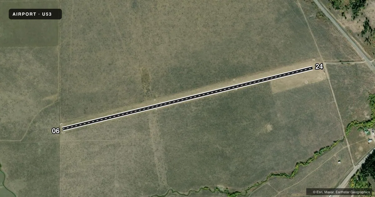
Runways & pattern
Full pagePattern entry · RWY 06
LEFT TRAFFICRunway end performance
| End | TORA | TODA | ASDA | LDA | VGSI | Approach lights | Obstruction |
|---|---|---|---|---|---|---|---|
| 06 | — | — | — | — | — | — | 4', fence, 0' from thr, 90' R of cntrln, slope 0 |
| 24 | — | — | — | — | — | — | 4', fence, 0' from thr, 90' R of cntrln, slope 0 |
Declared distances in feet. TORA = takeoff run available, TODA = takeoff distance, ASDA = accelerate-stop, LDA = landing distance.
Airport sketch
Runways drawn to scale from FAA survey coordinates, rendered over satellite imagery. Not for navigation.
Approaches & charts
Services on the field
Fuel grades, oxygen, maintenance, ramp storage and lighting — as declared to the FAA by the airport operator.
Fuel & services
- Fuel
- Not available
- Oxygen (bottled)
- Not available
- Oxygen (bulk)
- Not available
- Airframe repair
- Not available
- Power plant repair
- Not available
Ramp & ground
- Transient storage
- Tie-down
- Landing fee
- No fee published
- Wind indicator
- Yes
- Segmented circle
- Yes
Fuel & FBOs
Cheapest 100LL and Jet A on the field and nearby. Always confirm with the FBO before taxi.
Airport notes
Surface conditions, obstructions, local procedures, lighting outages and other notes published with each FAA cycle.
General notes
- NO WINTER MAINTENANCE.
- RECOMMEND LAND RWY 06 TAKEOFF RWY 24 WHEN WIND CONDITIONS ALLOW.
- LIVESTOCK & BIG GAME ANIMALS HAVE ACCESS TO RY DURING FALL, WINTER & SPRING; DO NOT LEAVE ACFT UNATNDD DURING THESE SEASONS.
- FOR CD CTC SALT LAKE ARTCC AT 801-320-2568.
- FIRST 500 FT OF RWY 6 ROUGH DUE TO UNEVEN SFC/BUNCH GRASS & RODENT ACT.
Approach & departure obstructions
- 0606/24 EDGES & THRS MARKED WITH WHITE ROCKS.
- 06SLOPE 0:1
- 24SLOPE 0:1
- 06+4 FT FENCE 20 FT ON CNTRLN.
- 244 FT BARB WIRE FENCE AT 0 FT, 90 FT RIGHT.
Other notes
- ESTABD PRIOR TO 15 MAY 1959.
VFR map & nearby airports
VFR sectional. Tap any ICAO chip to open that airport.
Key facts · U53
Answer card- ICAO
- U53
- Name
- HENRYS LAKE
- Location
- ISLAND PARK, IDAHO
- Elevation
- 6,596 ft MSL
- Traffic pattern altitude
- 7,596 ft MSL (1,000 AGL)
- Control tower
- Non-towered (use CTAF)
- Total runways
- 1
- Longest runway
- 06/24 · 4,600 ft
- Published ILS approaches
- 0
- Published frequencies
- 1
- Magnetic variation
- 16°
- Current flight rules
- VFR
- Current wind
- 000° at 0 kt
- Favored runway now
- –
Henrys Lake (U53) sits in Island Park, Idaho. The field elevation is 6,596 ft MSL. It has one runway. Runway 06/24 is 4,600 ft of turf, which makes this a high-elevation backcountry-style strip with limited margin for error on performance. There is no control tower. CTAF is 122.9.
No ILS approaches are published. Pattern altitude is not published, so use standard traffic pattern judgment for the field and verify current guidance before you go. The runway headings are magnetic. The published runway 06/24 headings are 76.271987289551° and 256.271987289551°.
There are no on-field FBOs listed. Check with the airport operator or the FBO directly by phone before arrival if you need services. Published remarks say no winter maintenance is provided. They also note livestock and big game can be on the runway in fall, winter and spring, so do not leave the aircraft unattended in those seasons. Runway 06 is recommended for landing when wind allows. Runway 24 has a mountain on the centerline beyond the departure area. It also has a fence near the right side. Runway 06 has rough pavement-free turf in the first 700 feet. It also has fence and edge markers made of white rocks. Expect a short-field mindset and verify the current Chart Supplement before flying in.