METAR & TAF KEKS
Current METAR
Observed 11:10Z
KEKS 271110Z AUTO 14006KT 10SM FEW023 BKN037 OVC055 14/10 A3018 RMK AO2
- Wind
- 140° @ 6 kt
- Visibility
- 10 SM
- Temp / Dew
- 14°C / 10°C
- Altimeter
- 30.18 inHg
- Clouds
- OVC
- Density alt
- 6,294 ft
- Ceiling
- 3,700 ft AGL
- Rules
- VFR
Airport info & contacts
Manager on record, flight service, ARTCC, attendance schedule and pattern altitude — published by the FAA and refreshed every 28 days.
Location
- From city
- 6 NM SE
- VFR sectional
- GREAT FALLS
- ARTCC
- ZLC · SALT LAKE CITY
- NOTAM facility
- GTF (NOTAM-D)
Airport manager
- Name
- TROY HUNTER
- Phone
- 406-682-7502
- Address
- 35 AIRPORT ROAD, ENNIS MT 59729
Flight service · Hours
- FSS GTF
- GREAT FALLS1-800-WX-BRIEF
- Attendance
- 0700-1700
Frequencies
Tap any row to copy the frequency to your clipboard.
Runways & pattern
Full pagePattern entry · RWY 16
RIGHT TRAFFICRunway end performance
| End | TORA | TODA | ASDA | LDA | VGSI | Approach lights | Obstruction |
|---|---|---|---|---|---|---|---|
| 16 | — | — | — | — | PAPI 4-box left(3°) | — | 56', fence, 1765' from thr, 350' R of cntrln, slope 27 |
| 34 | — | — | — | — | PAPI 4-box left(3°) | — | — |
Declared distances in feet. TORA = takeoff run available, TODA = takeoff distance, ASDA = accelerate-stop, LDA = landing distance.
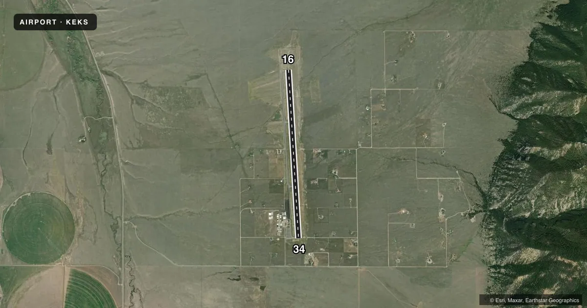
Airport sketch
Runways drawn to scale from FAA survey coordinates, rendered over satellite imagery. Not for navigation.
Approaches & charts
Services on the field
Fuel grades, oxygen, maintenance, ramp storage and lighting — as declared to the FAA by the airport operator.
Fuel & services
- Fuel
- 100LLA1A1+
- Airframe repair
- Minor
- Power plant repair
- Minor
- Other services
- AMB,CHTR,INSTR,RNTL
Ramp & ground
- Transient storage
- Tie-down
- Hangar
- Landing fee
- No fee published
- Lighting schedule
- SEE RMK
- Beacon schedule
- SS-SR
- Beacon
- White / Green (civil land)(WG)
- Wind indicator
- Lighted
- Segmented circle
- Yes
Fuel & FBOs
Cheapest 100LL and Jet A on the field and nearby. Always confirm with the FBO before taxi.
Airport notes
Surface conditions, obstructions, local procedures, lighting outages and other notes published with each FAA cycle.
General notes
- AFLD SFC COND UNMONITORED 1700-0700.
- FOR SVC AFTER HRS CALL (406) 682-7502.
- AFTER HRS CREDIT CARD FUELING.
- DE-ICING TYPE 1 AVAIL.
- FOR CD CTC BIG SKY APCH AT 208-364-5860/5861, IF UNABLE CTC SALT LAKE ARTCC AT 801-320-2568.
- COLD TEMPERATURE AIRPORT. ALTITUDE CORRECTION REQUIRED AT OR BELOW -24C.
Lighting notes
- ACTVT MIRL RWY 16/34 - CTAF. PAPI RWY 16 & 34 OPR CONSLY.
Approach & departure obstructions
- 1616/34 1020 FT DIST MKRS EACH END.
VFR map & nearby airports
VFR sectional. Tap any ICAO chip to open that airport.
Key facts · KEKS
Answer card- ICAO
- KEKS
- Name
- ENNIS BIG SKY
- Location
- ENNIS, MONTANA
- Elevation
- 5,432.6 ft MSL
- Traffic pattern altitude
- 6,432.6 ft MSL (1,000 AGL)
- Control tower
- Non-towered (use CTAF)
- Total runways
- 1
- Longest runway
- 16/34 · 7,600 ft
- Published ILS approaches
- 0
- Published frequencies
- 4
- Magnetic variation
- 12°
- Current flight rules
- VFR
- Current wind
- 140° at 6 kt
- Favored runway now
- RWY 16
Ennis Big Sky Airport sits in Ennis, Montana. The field elevation is 5,432.6 ft MSL. It has one runway, 16/34, which is 7,600 ft long. There is no control tower. Pattern altitude is not published, so use the standard 1,000 ft AGL for light piston operations unless the current Chart Supplement says otherwise. That puts the traffic pattern near 6,400 ft MSL.
No ILS approaches are published here. Big Sky Approach handles clearance delivery. If you cannot reach them, Salt Lake ARTCC is the backup contact listed in the remarks. The runway lights on 16/34 are activated by CTAF. The PAPI on both runway ends operates continuously. Runways 16 and 34 also have 1,020 ft distance markers at each end.
Ascension FBO is on the field. It carries AVGAS 100LL, Jet A and Jet A Prist. After-hours service and fueling are available by phone. This is a cold temperature airport, so altitude correction is required at or below minus 24 degrees Celsius. Airfield surface condition is unmonitored from 1700 to 0700. Plan extra caution if you are arriving late. The field sits in a mountain state environment with high elevation, so performance planning matters even with a long runway.