METAR & TAF KWYS
Current METAR
Observed 11:15Z
KWYS 271115Z AUTO 02003KT 10SM FEW035 SCT055 SCT075 14/12 A3022 RMK AO2
- Wind
- 020° @ 3 kt
- Visibility
- 10 SM
- Temp / Dew
- 14°C / 12°C
- Altimeter
- 30.22 inHg
- Clouds
- SCT
- Density alt
- 7,753 ft
- Ceiling
- Unlimited
- Rules
- VFR
Airport info & contacts
Manager on record, flight service, ARTCC, attendance schedule and pattern altitude — published by the FAA and refreshed every 28 days.
Location
- From city
- 1 NM N
- VFR sectional
- GREAT FALLS
- ARTCC
- ZLC · SALT LAKE CITY
- NOTAM facility
- WYS (NOTAM-D)
Airport manager
- Name
- JEFF KADLEC
- Phone
- 406-646-7631
- Address
- 721 AIRPORT RD., P.O. BOX 306, WEST YELLOWSTONE MT 59758-0306
Flight service · Hours
- FSS GTF
- GREAT FALLS1-800-WX-BRIEF
- Attendance
- MAY-OCT · 0800-1700
Frequencies
Tap any row to copy the frequency to your clipboard.
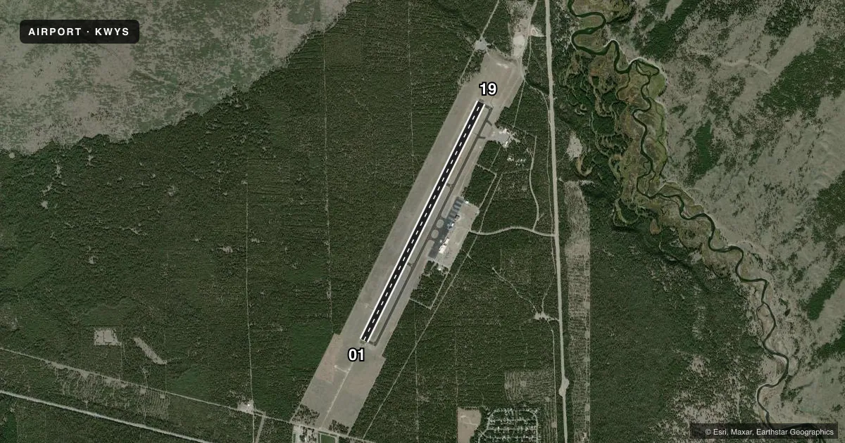
Runways & pattern
Full pagePattern entry · RWY 01
LEFT TRAFFICRunway end performance
| End | TORA | TODA | ASDA | LDA | VGSI | Approach lights | Obstruction |
|---|---|---|---|---|---|---|---|
| 01 | 8,400' | 8,400' | 8,400' | 8,400' | PAPI 4-box left(3°) | MALSR | — |
| 19 | 8,400' | 8,400' | 8,400' | 8,400' | PAPI 4-box left(3°) | — | — |
Declared distances in feet. TORA = takeoff run available, TODA = takeoff distance, ASDA = accelerate-stop, LDA = landing distance.
Airport sketch
Runways drawn to scale from FAA survey coordinates, rendered over satellite imagery. Not for navigation.
Approaches & charts
ILS · 1
Services on the field
Fuel grades, oxygen, maintenance, ramp storage and lighting — as declared to the FAA by the airport operator.
Fuel & services
- Fuel
- 100LLA1+
Ramp & ground
- Transient storage
- Tie-down
- Landing fee
- Yes
- Customs
- Not available
- Lighting schedule
- SEE RMK
- Beacon schedule
- SS-SR
- Beacon
- White / Green (civil land)(WG)
- Wind indicator
- Lighted
- Segmented circle
- Yes
Fuel & FBOs
Cheapest 100LL and Jet A on the field and nearby. Always confirm with the FBO before taxi.
Airport notes
Surface conditions, obstructions, local procedures, lighting outages and other notes published with each FAA cycle.
General notes
- SNOW REMOVAL NA. WINTER SNOWMOBILE ACT ON & INVOF OF ARPT.
- CLSD 31 OCT - 01 MAY; CK NOTAMS - AMGR OR 406-459-9825
- COLD TEMPERATURE AIRPORT. ALTITUDE CORRECTION REQUIRED AT OR BELOW -19C.
- COND UNMNT 1700-0800.
- FOR CD CTC SALT LAKE ARTCC AT 801-320-2568 .
Lighting notes
- ACTVT MALSR RWY 01; REIL RWY 19; HIRL RWY 01/19 - CTAF. PAPI RWY 01 & 19 OPR CONSLY. NOT AVBL 31 OCT- 7 MAY .
Fuel notes
- 100LLOFF SEASON FUEL- 406-646-7359.
Runway surface & condition
- 01/19PCR VALUE: 1490/F/A/X/T
Other notes
- THIS AIRPORT HAS BEEN SURVEYED BY THE NATIONAL GEODETIC SURVEY.
- PPR FOR ACR OPS GTR THAN 30 PAX - AMGR OR 406-459-9825.
- TURBINE PWRD LDG FEE.
- 2WX DEPENDENT.
- MANAGER406-459-9825/406-444-2506.
VFR map & nearby airports
VFR sectional. Tap any ICAO chip to open that airport.
Key facts · KWYS
Answer card- ICAO
- KWYS
- Name
- YELLOWSTONE
- Location
- WEST YELLOWSTONE, MONTANA
- Elevation
- 6,649 ft MSL
- Traffic pattern altitude
- 7,649 ft MSL (1,000 AGL)
- Control tower
- Non-towered (use CTAF)
- Total runways
- 1
- Longest runway
- 01/19 · 8,400 ft
- Published ILS approaches
- 1
- Published frequencies
- 2
- Magnetic variation
- 14°
- Current flight rules
- VFR
- Current wind
- 020° at 3 kt
- Favored runway now
- RWY 01
Yellowstone Airport sits in West Yellowstone, Montana. Field elevation is 6,649 ft MSL. The airport has one runway, 01/19, at 8,400 ft. There is no control tower. CTAF and UNICOM are both 123.0. An ILS is published for runway 01. Pattern altitude is not published, so use the standard 1,000 ft AGL for light piston traffic unless the current Chart Supplement says otherwise.
Ascension FBO is on the field. It carries 100LL, Jet A and Jet A Prist. For winter planning, this field closes from October 31 to May 1. Snow removal is not available. Winter snowmobile activity occurs on and near the airport. Conditions are unmonitored from 1700 to 0800. PAPI on both runways is continuous, but it is not available from October 31 to May 7. MALSR is available for runway 01. REIL is available for runway 19. This is a cold temperature airport. Altitude correction is required at or below minus 19 degrees Celsius.
Expect mountain airport performance planning. The elevation is high. Density altitude can climb fast in warm weather. Check current NOTAMs before you go. If you need clearance delivery, Salt Lake ARTCC handles it by phone. For any winter or operational question, call the airport manager directly before departure.