METAR & TAF U41
U41 does not publish a METAR.
Showing the nearest reporting station: KRXE (REXBURG-MADISON COUNTY) · 26.7 NM away. Conditions at U41 may differ.
METAR · KRXE
Observed 07:53Z
KRXE 270753Z AUTO VRB04KT 10SM CLR 25/11 A3003 RMK AO2 SLP105 T02500106
- Wind
- VAR @ 4 kt
- Visibility
- 10 SM
- Temp / Dew
- 25°C / 11°C
- Altimeter
- 30.03 inHg
- Clouds
- CLR
- Density alt
- 7,416 ft
- Ceiling
- Unlimited
- Rules
- VFR
Airport info & contacts
Manager on record, flight service, ARTCC, attendance schedule and pattern altitude — published by the FAA and refreshed every 28 days.
Location
- From city
- 1 NM SE
- VFR sectional
- SALT LAKE CITY
- ARTCC
- ZLC · SALT LAKE CITY
- NOTAM facility
- BOI (NOTAM-D)
Airport manager
- Name
- NOE PEREZ
- Phone
- 208-390-5673
- Address
- PO BOX 27, DUBOIS ID 83423
Flight service · Hours
- FSS BOI
- BOISE1-800-WX-BRIEF
- Attendance
- Unattended
Frequencies
Tap any row to copy the frequency to your clipboard.
Runways & pattern
Full pagePattern entry · RWY 34
RIGHT TRAFFICRunway end performance
| End | TORA | TODA | ASDA | LDA | VGSI | Approach lights | Obstruction |
|---|---|---|---|---|---|---|---|
| 16 | — | — | — | — | — | — | 15', road, 115' from thr, 0' R of cntrln, slope 7 |
Declared distances in feet. TORA = takeoff run available, TODA = takeoff distance, ASDA = accelerate-stop, LDA = landing distance.
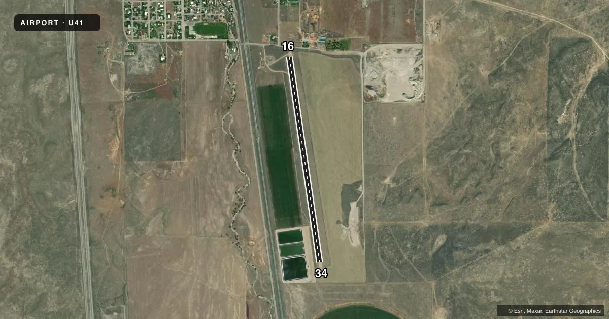
Airport sketch
Runways drawn to scale from FAA survey coordinates, rendered over satellite imagery. Not for navigation.
Approaches & charts
Services on the field
Fuel grades, oxygen, maintenance, ramp storage and lighting — as declared to the FAA by the airport operator.
Fuel & services
- Fuel
- Not available
- Oxygen (bottled)
- Not available
- Oxygen (bulk)
- Not available
- Airframe repair
- Not available
- Power plant repair
- Not available
- Other services
- AGRI
Ramp & ground
- Transient storage
- Tie-down
- Landing fee
- No fee published
- Customs
- Not available
- Wind indicator
- Yes
- Segmented circle
- Yes
Fuel & FBOs
Cheapest 100LL and Jet A on the field and nearby. Always confirm with the FBO before taxi.
Airport notes
Surface conditions, obstructions, local procedures, lighting outages and other notes published with each FAA cycle.
General notes
- NO WINTER MAINTENANCE.
- FOR CD CTC SALT LAKE ARTCC AT 801-320-2568.
Runway surface & condition
- 16/3460 FT GRVL STRIP IS CNTRD BTN THE 300 FT ARPT BDRY MKRS.
Approach & departure obstructions
- 1616/34 CONE BDRY MKRS 140 FT EACH SIDE OF RWY CNTRLN AND WOOD PANELS ACRS BOTH THRS.
- 16RWY 16 6 FT FENCE AT 500 FT FM THLD ON CNTRLN. 75 FT STEEPLE 1400 FT FM THLD, 100 FT LEFT.
Other notes
- ESTAB PRIOR TO 15 MAY 1959.
VFR map & nearby airports
VFR sectional. Tap any ICAO chip to open that airport.
Key facts · U41
Answer card- ICAO
- U41
- Name
- DUBOIS MUNI
- Location
- DUBOIS, IDAHO
- Elevation
- 5,123 ft MSL
- Traffic pattern altitude
- 6,123 ft MSL (1,000 AGL)
- Control tower
- Non-towered (use CTAF)
- Total runways
- 1
- Longest runway
- 16/34 · 4,600 ft
- Published ILS approaches
- 0
- Published frequencies
- 1
- Magnetic variation
- 16°
- Current flight rules
- VFR
- Current wind
- 000° at 4 kt
- Favored runway now
- RWY 34
Dubois Muni sits in Dubois, Idaho. The field elevation is 5,123 ft MSL. It has one runway. Runway 16/34 is 4,600 ft long and surfaced in gravel and dirt. There is no control tower. CTAF is 122.9. No ILS approaches are published here.
Pattern altitude is not published. Use the standard 1,000 ft AGL pattern unless the current FAA Chart Supplement says otherwise. That puts the traffic pattern at about 6,123 ft MSL. This is a high-elevation field, so expect performance changes on warm days. The airport also has no winter maintenance, so surface condition matters before you go.
Published remarks call out several runway hazards. Runway 16 has a fence on the centerline near the departure end. There is also a steeple off the left side farther out. The runway edge is marked with cones and threshold panels. The strip is centered between airport boundary markers. For clearance delivery, contact Salt Lake ARTCC at 801-320-2568. No on-field FBOs are listed, so verify services with the airport operator or call the field directly before arrival.