METAR & TAF KRXE
Current METAR
Observed 08:53Z
KRXE 270853Z AUTO 00000KT 10SM CLR 22/14 A3004 RMK AO2 SLP109 T02220139 51002
- Wind
- 000° @ 0 kt
- Visibility
- 10 SM
- Temp / Dew
- 22°C / 14°C
- Altimeter
- 30.04 inHg
- Clouds
- CLR
- Density alt
- 6,720 ft
- Ceiling
- Unlimited
- Rules
- VFR
Airport info & contacts
Manager on record, flight service, ARTCC, attendance schedule and pattern altitude — published by the FAA and refreshed every 28 days.
Location
- From city
- 1 NM NW
- VFR sectional
- SALT LAKE CITY
- ARTCC
- ZLC · SALT LAKE CITY
- NOTAM facility
- RXE (NOTAM-D)
Airport manager
- Name
- DAVID TAYLOR
- Phone
- 208-356-9960
- Address
- PO BOX 70, REXBURG ID 83440
Flight service · Hours
- FSS BOI
- BOISE1-800-WX-BRIEF
- Attendance
- MON-SAT · 0800-1800
Frequencies
Tap any row to copy the frequency to your clipboard.
Runways & pattern
Full pagePattern entry · RWY 17
LEFT TRAFFICRunway end performance
| End | TORA | TODA | ASDA | LDA | VGSI | Approach lights | Obstruction |
|---|---|---|---|---|---|---|---|
| 17 | 4,200' | 4,200' | 4,200' | 3,900' | VASI 4-box right | — | 35', trees, 470' from thr, 150' R of cntrln, slope 7 |
| 35 | 4,200' | 4,200' | 3,900' | 3,900' | VASI 4-box left(3°) | — | 50', tree, 725' from thr, 150' R of cntrln, slope 10 |
Declared distances in feet. TORA = takeoff run available, TODA = takeoff distance, ASDA = accelerate-stop, LDA = landing distance.
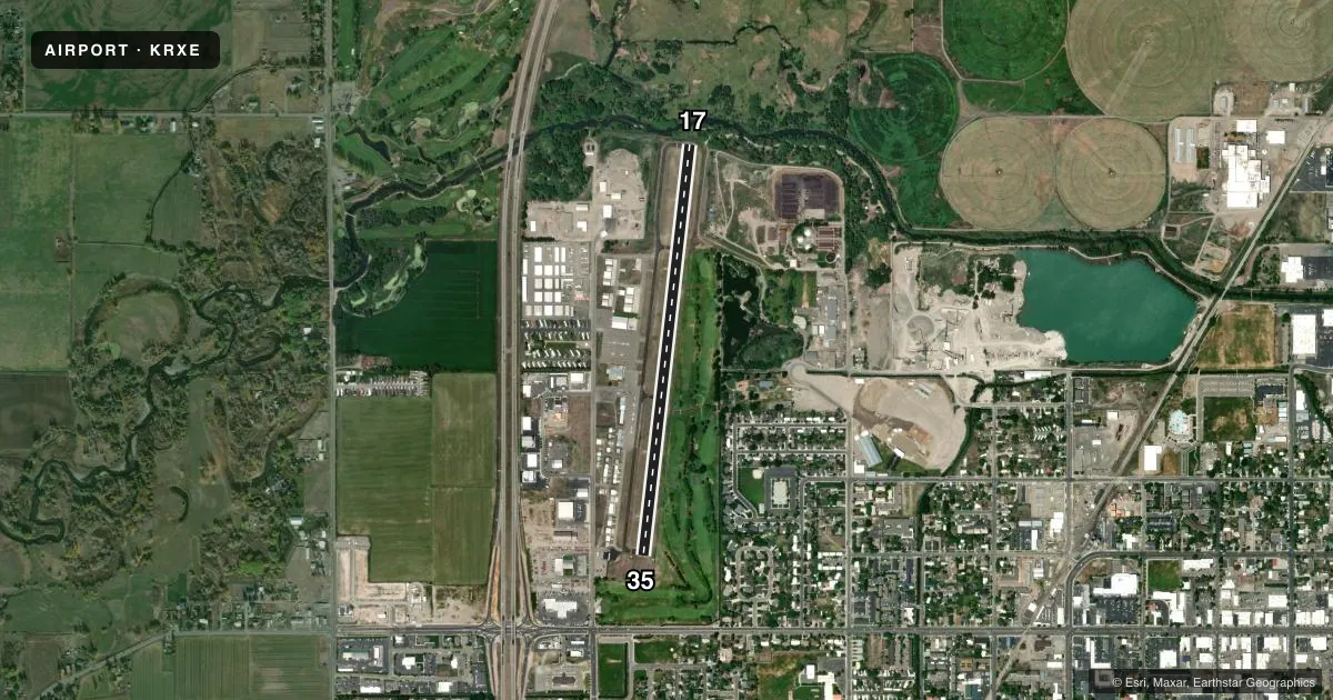
Airport sketch
Runways drawn to scale from FAA survey coordinates, rendered over satellite imagery. Not for navigation.
Approaches & charts
Services on the field
Fuel grades, oxygen, maintenance, ramp storage and lighting — as declared to the FAA by the airport operator.
Fuel & services
- Fuel
- 100LLA
- Oxygen (bottled)
- High pressure
- Oxygen (bulk)
- Not available
- Airframe repair
- Major
- Power plant repair
- Major
- Other services
- INSTR,RNTL
Ramp & ground
- Transient storage
- Tie-down
- Landing fee
- No fee published
- Customs
- Not available
- Lighting schedule
- SEE RMK
- Beacon schedule
- SS-SR
- Beacon
- White / Green (civil land)(WG)
- Wind indicator
- Yes
- Segmented circle
- Yes
Fuel & FBOs
Cheapest 100LL and Jet A on the field and nearby. Always confirm with the FBO before taxi.
Airport notes
Surface conditions, obstructions, local procedures, lighting outages and other notes published with each FAA cycle.
General notes
- FOR CD CTC SALT LAKE ARTCC AT 801-320-2568.
Lighting notes
- ACTVT REIL RWY 35; VASI RWY 35; MIRL 17/35 - CTAF. VASI RWY 17 OPR CONSLY.
Approach & departure obstructions
- 17+20 TO 50 FT TREES AT 160 FT; 150 FT LEFT & RIGHT.
- 17RWY 17 APCH SLOPE 26:1 TO DSPLCD THLD.
Other notes
- ESTABD PRIOR TO 15 MAY 1959.
- MANAGEREMAIL: KEITH.DAVIDSON@REXBURG.ORG
VFR map & nearby airports
VFR sectional. Tap any ICAO chip to open that airport.
Key facts · KRXE
Answer card- ICAO
- KRXE
- Name
- REXBURG-MADISON COUNTY
- Location
- REXBURG, IDAHO
- Elevation
- 4,862 ft MSL
- Traffic pattern altitude
- 5,862 ft MSL (1,000 AGL)
- Control tower
- Non-towered (use CTAF)
- Total runways
- 1
- Longest runway
- 17/35 · 4,204 ft
- Published ILS approaches
- 0
- Published frequencies
- 2
- Magnetic variation
- 15°
- Current flight rules
- VFR
- Current wind
- 000° at 0 kt
- Favored runway now
- –
Rexburg-Madison County Airport sits in Rexburg, Idaho. The field elevation is 4,862 ft MSL. It has one runway. Runway 17/35 is 4,204 ft long with an asphalt surface. This is a non-towered field, so use CTAF 122.8 for local traffic calls. No ILS approaches are published here.
Pattern altitude is not published. Use the standard 1,000 ft AGL pattern unless the current Chart Supplement or local procedures say otherwise. That puts the light-piston pattern at about 5,862 ft MSL. The airport sits high enough that density altitude can matter, especially on warm days. Expect takeoff and climb performance to feel different than at lower-elevation fields.
Rexburg Air Service is on the field. It carries 100LL, Jet A and Jet A Prist. Copter Doctor Plus is also on the field. It carries 100LL. Runway 35 has REIL and a VASI. Runways 17 and 35 have medium intensity runway lights on CTAF control. The VASI on runway 17 operates continuously. Trees are close to the runway 17 end. The approach to 17 is steep and displaced. Use extra caution on short final and on departure from the south end. For clearance delivery, contact Salt Lake ARTCC before flight if needed.