METAR & TAF KBZN
Current METAR
Observed 04:56Z
KBZN 280456Z 18007KT 10SM SCT100 23/12 A3006 RMK AO2 SLP132 T02280117
- Wind
- 180° @ 7 kt
- Visibility
- 10 SM
- Temp / Dew
- 23°C / 12°C
- Altimeter
- 30.06 inHg
- Clouds
- SCT
- Density alt
- 6,333 ft
- Ceiling
- Unlimited
- Rules
- VFR
Airport info & contacts
Manager on record, flight service, ARTCC, attendance schedule and pattern altitude — published by the FAA and refreshed every 28 days.
Location
- From city
- 7 NM NW
- VFR sectional
- GREAT FALLS
- ARTCC
- ZLC · SALT LAKE CITY
- NOTAM facility
- BZN (NOTAM-D)
Airport manager
- Name
- BRIAN SPRENGER
- Phone
- 406-388-6632
- Address
- 850 GALLATIN FIELD RD, SUITE 6, BELGRADE MT 59714
Flight service · Hours
- FSS GTF
- GREAT FALLS1-800-WX-BRIEF
- Attendance
- 0430-0100
Frequencies
Tap any row to copy the frequency to your clipboard.
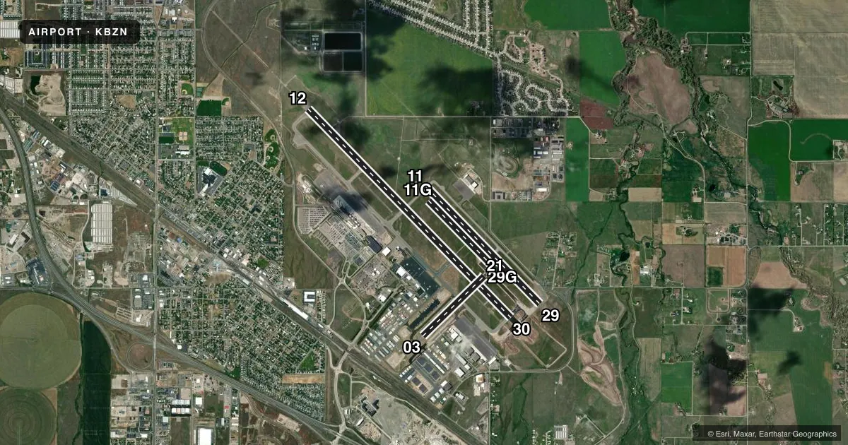
Runways & pattern
Full pagePattern entry · RWY 12
LEFT TRAFFIC| Runway | Heading (°M) | Length | Surface | Traffic |
|---|---|---|---|---|
| 12/30Favored | 123° / 303° | 8,994 ft | ASPH | Standard L |
| 11/29 | 123° / 303° | 5,050 ft | ASPH | Standard L |
| 11G/29G | 123° / 303° | 2,802 ft | TURF | Standard L |
| 03/21 | 33° / 213° | 2,650 ft | ASPH | Standard L |
Runway end performance
| End | TORA | TODA | ASDA | LDA | VGSI | Approach lights | Obstruction |
|---|---|---|---|---|---|---|---|
| 12 | 8,994' | 8,994' | 8,994' | 8,994' | PAPI 4-box left(3°) | MALSR | — |
| 30 | 8,994' | 8,994' | 8,994' | 8,994' | PAPI 4-box left(3.2°) | MALSR | — |
| 11 | 5,050' | 5,050' | 5,050' | 5,050' | PAPI 4-box left(3°) | — | — |
| 29 | 5,050' | 5,050' | 5,050' | 5,050' | PAPI 4-box left(3°) | — | — |
| 03 | 2,650' | 2,650' | 2,650' | 2,650' | — | — | — |
| 21 | 2,650' | 2,650' | 2,650' | 2,650' | — | — | — |
Declared distances in feet. TORA = takeoff run available, TODA = takeoff distance, ASDA = accelerate-stop, LDA = landing distance.
Airport sketch
Runways drawn to scale from FAA survey coordinates, rendered over satellite imagery. Not for navigation.
Approaches & charts
ILS · 1
Services on the field
Fuel grades, oxygen, maintenance, ramp storage and lighting — as declared to the FAA by the airport operator.
Fuel & services
- Fuel
- 100100LLA
- Oxygen (bottled)
- HIGH/LOW
- Oxygen (bulk)
- HIGH/LOW
- Airframe repair
- Major
- Power plant repair
- Major
- Other services
- AFRT,AGRI,CHTR,GLD,INSTR,PAJA,RNTL,SALES,SURV,TOW
Ramp & ground
- Transient storage
- Tie-down
- Hangar
- Landing fee
- Yes
- Customs
- Not available
- Lighting schedule
- SEE RMK
- Beacon schedule
- SS-SR
- Beacon
- White / Green (civil land)(WG)
- Wind indicator
- Lighted
- Segmented circle
- No
Fuel & FBOs
Cheapest 100LL and Jet A on the field and nearby. Always confirm with the FBO before taxi.
Airport notes
Surface conditions, obstructions, local procedures, lighting outages and other notes published with each FAA cycle.
General notes
- SNOW REMOVAL EQUIP - CTAF.
- COLD TEMPERATURE AIRPORT. ALTITUDE CORRECTION REQUIRED AT OR BELOW -21C.
- BIRDS INVOF ARPT.
- STUDENT TRNG ACT WI 15 MI.
- 180 DEG TURN NA ON TRML RAMP.
- PILOTS CONDUCTING EFVS OPS; BE AWARE LED ALS IN USE RWY 12.
- FOR CD WHEN ATCT CLSD CTC BIG SKY APCH AT 208-364-5860, WHEN ATCT AND APCH CLSD CTC SALT LAKE ARTCC AT 801-320-2568.
- NOISE: TRAINING TRAFFIC - CHECK VOLUNTARY NOISE ABATEMENT PRO
Lighting notes
- WHEN ATCT CLSD ACTVT MALSR RWY 12 & 30; HIRL RWY 12/30; MIRL RWY 11/29 - CTAF. PAPI RWY 12 & 30 OPR CONSLY.
Runway surface & condition
- 03/21PCR VALUE: 465/F/A/X/U
- 11/29PCR VALUE: 260/F/A/X/U
- 12/30PCR VALUE: 1410/F/A/X/U
- 11G/29G240 FT S OF RWY 11/29; AVBL WHEN DRY WITH ATC APVL.
Approach & departure obstructions
- 03TKOF NA UNTIL CFMG NO TFC USING RWY 12.
- 12ARR & DEP OPS WHEN WIND LESS THAN 10 KT; OTR RWY MAY BE USED; EXPC DLA.
- 21LCTD BTN RWY 12/30 & TWY A; AVBL GTR THAN 12500 LB DAY/VFR ONLY.
- 11GCONES.
- 29GCONES.
Other notes
- U.S. CUSTOMS AVBL 1600Z-2400Z THU-MON.
VFR map & nearby airports
VFR sectional. Tap any ICAO chip to open that airport.
Key facts · KBZN
Answer card- ICAO
- KBZN
- Name
- BOZEMAN YELLOWSTONE INTL
- Location
- BOZEMAN, MONTANA
- Elevation
- 4,473.4 ft MSL
- Traffic pattern altitude
- 5,473.4 ft MSL (1,000 AGL)
- Control tower
- Towered · 0530-0030
- Total runways
- 4
- Longest runway
- 12/30 · 8,994 ft
- Published ILS approaches
- 1
- Published frequencies
- 8
- Magnetic variation
- 13°
- Current flight rules
- VFR
- Current wind
- 180° at 7 kt
- Favored runway now
- RWY 12
Bozeman Yellowstone Intl is in Bozeman, Montana. The field elevation is 4,473.4 ft MSL. It has four runways. The longest is runway 12/30 at 8,994 ft. The tower is open daily from 0530 to 0030. One ILS is published for runway 12.
Pattern altitude is not published in the facts. Use the current FAA Chart Supplement before you fly and verify the traffic pattern picture for your aircraft. This is a high-elevation airport, so performance planning matters. Cold temperature correction is required at or below minus 21 degrees Celsius. Runway 12 has special notes too. Arrival and departure operations on 12 are authorized when wind is less than 10 knots. Expect delay if another runway is needed.
Three FBOs are on the field. Million Air carries 100LL, Jet A and Jet A Prist. Signature Aviation carries 100LL and Jet A. Jet Aviation Bozeman carries 100LL, Jet A and Jet A Prist. The airport also has customs service Thursday through Monday from 1600Z to 2400Z. When the tower is closed, clearance delivery goes through Big Sky Approach. If approach is closed too, use Salt Lake ARTCC. Runway 12 uses LED approach lighting. Runway 12 and 30 lighting can be activated when the tower is closed. Student training activity is reported within 15 miles. Expect a busy pattern.