METAR & TAF U12
U12 does not publish a METAR.
Showing the nearest reporting station: KRXE (REXBURG-MADISON COUNTY) · 8.7 NM away. Conditions at U12 may differ.
METAR · KRXE
Observed 11:53Z
KRXE 271153Z AUTO 18007KT 10SM CLR 23/08 A3008 RMK AO2 SLP118 T02330083 10261 20217 51012
- Wind
- 180° @ 7 kt
- Visibility
- 10 SM
- Temp / Dew
- 23°C / 8°C
- Altimeter
- 30.08 inHg
- Clouds
- CLR
- Density alt
- 6,919 ft
- Ceiling
- Unlimited
- Rules
- VFR
Airport info & contacts
Manager on record, flight service, ARTCC, attendance schedule and pattern altitude — published by the FAA and refreshed every 28 days.
Location
- From city
- 1 NM SE
- VFR sectional
- SALT LAKE CITY
- Pattern altitude
- 800 ft AGL · 5,766 ft MSL
- ARTCC
- ZLC · SALT LAKE CITY
- NOTAM facility
- BOI (NOTAM-D)
Airport manager
- Name
- DIRK FORBUSH
- Phone
- 208-313-6594
- Address
- 110 W MAIN, ST. ANTHONY ID 83445
Flight service · Hours
- FSS BOI
- BOISE1-800-WX-BRIEF
- Attendance
- UNATTENDED
Frequencies
Tap any row to copy the frequency to your clipboard.
Runways & pattern
Full pagePattern entry · RWY 22
LEFT TRAFFICRunway end performance
| End | TORA | TODA | ASDA | LDA | VGSI | Approach lights | Obstruction |
|---|---|---|---|---|---|---|---|
| 04 | — | — | — | — | PAPI 2-box right(3.5°) | — | 10', berm, 0' from thr, 110' R of cntrln, slope 0 |
| 22 | — | — | — | — | — | — | 55', tree, 490' from thr, 110' R of cntrln, slope 5 |
Declared distances in feet. TORA = takeoff run available, TODA = takeoff distance, ASDA = accelerate-stop, LDA = landing distance.
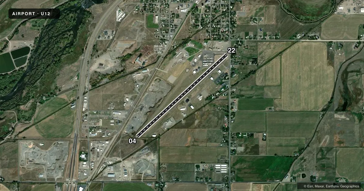
Airport sketch
Runways drawn to scale from FAA survey coordinates, rendered over satellite imagery. Not for navigation.
Approaches & charts
Services on the field
Fuel grades, oxygen, maintenance, ramp storage and lighting — as declared to the FAA by the airport operator.
Fuel & services
- Fuel
- 100LLA
- Other services
- AGRI
Ramp & ground
- Transient storage
- Tie-down
- Landing fee
- No fee published
- Customs
- Not available
- Lighting schedule
- SEE RMK
- Beacon schedule
- SEE RMK
- Beacon
- White / Green (civil land)(WG)
- Wind indicator
- Lighted
- Segmented circle
- Yes
Fuel & FBOs
Cheapest 100LL and Jet A on the field and nearby. Always confirm with the FBO before taxi.
Airport notes
Surface conditions, obstructions, local procedures, lighting outages and other notes published with each FAA cycle.
General notes
- CROP DUSTERS OPER FM GRVL RWY ADJ NORTH OF PAVED RWY DRG AGRI SEASON.
- FOR CD CTC SALT LAKE ARTCC AT 801-320-2568.
- 85 FT PLINE; 2600 FT ON EXTDD CNTRLN ON APCH TO RWY 04.
Lighting notes
- ACTVT BCN - CTAF.
- ACTVT REILS RWY 04 & 22; MIRL RWY 04/22 - CTAF.
Fuel notes
- 100LLFUEL 24 HR CREDIT CARD SVC AVBL.
Approach & departure obstructions
- 045 FT FENCE 0 FT, 90 FT LEFT.
- 22NMRS CLOSE-IN OBSTS; FENCE, SIGNS &TREES LCTD IN PRIM SFC.
- 04RWY 04/22 - 04: 25:1 SLOPE TO DSPLCD THR.
- 2221:1 TO DSPLCD THLD.
- 2255 FT TREES 490 FT, 110 FT LEFT.
Other notes
- ESTABD PRIOR TO 15 MAY 1959.
- SEGMENTED CRC IS NSTD - PAINTED TIRES.
- 1UNATNDD.
VFR map & nearby airports
VFR sectional. Tap any ICAO chip to open that airport.
Key facts · U12
Answer card- ICAO
- U12
- Name
- STANFORD FLD
- Location
- ST ANTHONY, IDAHO
- Elevation
- 4,966 ft MSL
- Traffic pattern altitude
- 5,766 ft MSL (800 AGL)
- Control tower
- Non-towered (use CTAF)
- Total runways
- 1
- Longest runway
- 04/22 · 4,500 ft
- Published ILS approaches
- 0
- Published frequencies
- 1
- Magnetic variation
- 16°
- Current flight rules
- VFR
- Current wind
- 180° at 7 kt
- Favored runway now
- RWY 22
Stanford Fld sits in St Anthony, Idaho at 4,966 ft MSL. It has one runway, 04/22, which is 4,500 ft long and paved with asphalt. The airport is unattended. CTAF is 122.9. There is no control tower. No ILS approaches are published here.
Pattern altitude is 800 ft AGL, which is 5,766 ft MSL. That matters here because the field is already high elevation. Performance planning deserves a close look before departure or arrival. Runway 04 and runway 22 both have displaced thresholds. The published remarks also call out obstacle clearance slopes to those displaced thresholds. There is a 5-foot fence and an 8-foot berm near runway 04. Runway end identifier lights, the PAPI on runway 04 and the medium intensity runway lights are activated by using the CTAF. The beacon is also CTAF-controlled.
Shupe Flying Service is on the field. It carries 100LL. For clearance delivery, contact Salt Lake ARTCC. The airport also has a nonstandard segmented circle made of painted tires. During the agricultural season, aircraft operate from the gravel runway southeast of the paved runway. A first-time pilot should plan for the elevation. Plan for the displaced thresholds. Plan for the lighting controls before going in.