METAR & TAF U78
U78 does not publish a METAR.
Showing the nearest reporting station: KAFO (AFTON LINCOLN COUNTY/GENERAL BOYD L EDDINS FLD) · 28.5 NM away. Conditions at U78 may differ.
METAR · KAFO
Observed 09:15Z
KAFO 270915Z AUTO 21003KT 10SM BKN110 17/10 A3019 RMK AO2
- Wind
- 210° @ 3 kt
- Visibility
- 10 SM
- Temp / Dew
- 17°C / 10°C
- Altimeter
- 30.19 inHg
- Clouds
- BKN
- Density alt
- 7,151 ft
- Ceiling
- 11,000 ft AGL
- Rules
- VFR
Airport info & contacts
Manager on record, flight service, ARTCC, attendance schedule and pattern altitude — published by the FAA and refreshed every 28 days.
Location
- From city
- 1 NM SE
- VFR sectional
- SALT LAKE CITY
- ARTCC
- ZLC · SALT LAKE CITY
- NOTAM facility
- BOI (NOTAM-D)
Airport manager
- Name
- ALAN SKINNER
- Phone
- 208-547-2600
- Address
- 9 WEST 2ND SOUTH, SODA SPRINGS ID 83276
Flight service · Hours
- FSS BOI
- BOISE1-800-WX-BRIEF
- Attendance
- Unattended
Frequencies
Tap any row to copy the frequency to your clipboard.
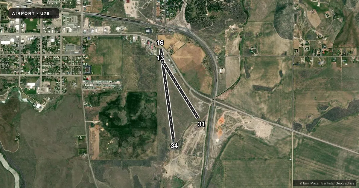
Runways & pattern
Full pagePattern entry · RWY 16
LEFT TRAFFIC| Runway | Heading (°M) | Length | Surface | Traffic |
|---|---|---|---|---|
| 16/34Favored | 157° / 337° | 3,500 ft | ASPH | Standard L |
| 13/31 | 133° / 313° | 2,500 ft | ASPH | Standard L |
Runway end performance
| End | TORA | TODA | ASDA | LDA | VGSI | Approach lights | Obstruction |
|---|---|---|---|---|---|---|---|
| 16 | — | — | — | — | TRIL | — | 15', road, 200' from thr, 100' R of cntrln, slope 0 |
| 34 | — | — | — | — | TRIL | — | — |
| 13 | — | — | — | — | — | — | 45', pole, 450' from thr, 50' R of cntrln, slope 5 |
| 31 | — | — | — | — | — | — | 40', pline, 600' from thr, 0' R of cntrln, slope 9 |
Declared distances in feet. TORA = takeoff run available, TODA = takeoff distance, ASDA = accelerate-stop, LDA = landing distance.
Airport sketch
Runways drawn to scale from FAA survey coordinates, rendered over satellite imagery. Not for navigation.
Approaches & charts
Services on the field
Fuel grades, oxygen, maintenance, ramp storage and lighting — as declared to the FAA by the airport operator.
Fuel & services
- Fuel
- 100LL
- Oxygen (bottled)
- Not available
- Oxygen (bulk)
- Not available
- Airframe repair
- Not available
- Power plant repair
- Not available
Ramp & ground
- Transient storage
- Tie-down
- Landing fee
- No fee published
- Customs
- Not available
- Lighting schedule
- SEE RMK
- Beacon schedule
- SEE RMK
- Beacon
- White / Green (civil land)(WG)
- Wind indicator
- Lighted
- Segmented circle
- Yes
Fuel & FBOs
Cheapest 100LL and Jet A on the field and nearby. Always confirm with the FBO before taxi.
Airport notes
Surface conditions, obstructions, local procedures, lighting outages and other notes published with each FAA cycle.
General notes
- SHARPLY DSNDG TRRN NEAR END RWYS 31 & 34.
- NMRS OBSTNS ON APCH TO RWYS 13 & 16.
- FOR CD CTC SALT LAKE ARTCC AT 801-320-2568.
- DAY VFR USE ONLY.
Lighting notes
- ROTG BCN OTS INDEF.
- ALL RWY LGTS ARE OTS INDEFLY.
Runway surface & condition
- 16/34NSTD LIRL FIRST 300 FT RWY 16 NOT LGTD.
Approach & departure obstructions
- 13+12 FT PARKED ACFT AT 0 FT 115 FT L.
- 16+15 FT HWY XS PRIM SFC 50 FT FM EOR; NMRS HIGH VEHICLES; NMRS CLOSE IN OBSTNS ON APCH TO RWY 16.
- 31+9 FT ROAD AT 60 FT ON CNTRLN.
- 16NO MARKGS - PAINT IS ALL GONE.
- 34RWY NRS ARE VERY DFCLT TO SEE - PAINT IS 90% GONE.
- 16TRI COLOR VASI OTS INDFLY.
- 34TRI COLOR VASI OTS INDFLY.
- 16+100 FT BARN/GRAIN ELEVATOR AT 775 FT, 200 FT L.
Other notes
- ESTABD PRIOR TO 15 MAY 1959.
- 1CALL 208-547-2600 OR 208-221-4494 FOR SVC.
- 13/31RWY IS VERY POOR, FULL OF OLD & UNTREATED CRACKS, GRASS GROWING THROUGH THEM, HAS NO MARKINGS, AND MANY AREAS WHERE THE TOP LAYER OF ASPH IS FLAKING OFF.
- 16/34RWY IS IN ROUGH SHAPE: VERY POOR MARKGS, UNTREATED CRACKS, ROUGH & EXPOSED AGGREGATE ASPH.
VFR map & nearby airports
VFR sectional. Tap any ICAO chip to open that airport.
Key facts · U78
Answer card- ICAO
- U78
- Name
- ALLEN H TIGERT
- Location
- SODA SPRINGS, IDAHO
- Elevation
- 5,843 ft MSL
- Traffic pattern altitude
- 6,843 ft MSL (1,000 AGL)
- Control tower
- Non-towered (use CTAF)
- Total runways
- 2
- Longest runway
- 16/34 · 3,500 ft
- Published ILS approaches
- 0
- Published frequencies
- 2
- Magnetic variation
- 15°
- Current flight rules
- VFR
- Current wind
- 210° at 3 kt
- Favored runway now
- RWY 16
Allen H Tigert Airport is in Soda Springs, Idaho. The field elevation is 5,843 ft MSL. It has two asphalt runways. The longest is runway 16/34 at 3,500 ft. There is no control tower. CTAF and UNICOM are both 122.8.
No ILS approaches are published here. Pattern altitude is not published, so verify the current Chart Supplement before you go. The on-field FBO is Allen H. Tigert Airport. It carries AVGAS 100LL. Call (208) 547-2600 for service. The airport also lists 208-221-4494 for service calls.
This is a high-elevation field, so performance planning matters. The published remarks also flag several runway issues. Runway 16/34 has very poor markings and rough asphalt. Runway 13/31 is in poor condition with cracking, flaking asphalt and no markings. Runway 16 has no markings. The paint is gone. The rotating beacon is out of service. There are also obstructions near runway 16. A highway is close to the departure end. A tall barn or grain elevator sits left of the extended centerline. If you are new to the field, study the current Chart Supplement and plan a careful look at the runway surface before landing.