METAR & TAF U10
U10 does not publish a METAR.
Showing the nearest reporting station: KLGU (LOGAN-CACHE) · 19.1 NM away. Conditions at U10 may differ.
METAR · KLGU
Observed 23:51Z
KLGU 252351Z AUTO 19008KT 10SM CLR 37/09 A3001 RMK AO2 SLP095 T03670094 10372 20311 58021
- Wind
- 190° @ 8 kt
- Visibility
- 10 SM
- Temp / Dew
- 37°C / 9°C
- Altimeter
- 30.01 inHg
- Clouds
- CLR
- Density alt
- 8,391 ft
- Ceiling
- Unlimited
- Rules
- VFR
Airport info & contacts
Manager on record, flight service, ARTCC, attendance schedule and pattern altitude — published by the FAA and refreshed every 28 days.
Location
- From city
- 2 NM NW
- VFR sectional
- SALT LAKE CITY
- ARTCC
- ZLC · SALT LAKE CITY
- NOTAM facility
- BOI (NOTAM-D)
Airport manager
- Name
- CRAIG BIGGS
- Phone
- 208-852-2151
- Address
- 1319 W 800 NORTH, PRESTON ID 83263
Flight service · Hours
- FSS BOI
- BOISE1-800-WX-BRIEF
- Attendance
- DALGT
Frequencies
Tap any row to copy the frequency to your clipboard.
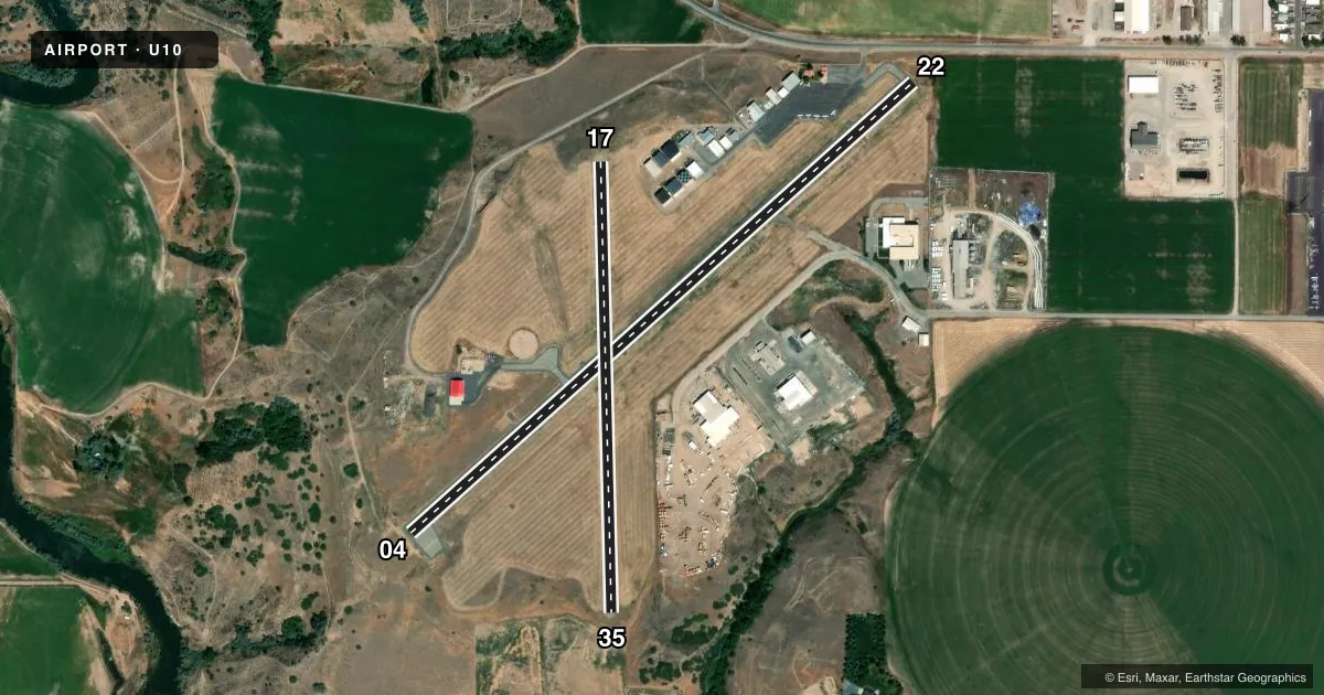
Runways & pattern
Full pagePattern entry · RWY 17
LEFT TRAFFIC| Runway | Heading (°M) | Length | Surface | Traffic |
|---|---|---|---|---|
| 04/22 | 33° / 213° | 3,557 ft | ASPH | Standard L |
| 17/35Favored | 164° / 344° | 2,375 ft | GRVL-DIRT | Standard L |
Runway end performance
| End | TORA | TODA | ASDA | LDA | VGSI | Approach lights | Obstruction |
|---|---|---|---|---|---|---|---|
| 04 | — | — | — | — | PAPI 2-box left(3°) | — | — |
| 22 | — | — | — | — | PAPI 2-box left(3°) | — | 17', road, 200' from thr, 70' R of cntrln, slope 0 |
Declared distances in feet. TORA = takeoff run available, TODA = takeoff distance, ASDA = accelerate-stop, LDA = landing distance.
Airport sketch
Runways drawn to scale from FAA survey coordinates, rendered over satellite imagery. Not for navigation.
Approaches & charts
Services on the field
Fuel grades, oxygen, maintenance, ramp storage and lighting — as declared to the FAA by the airport operator.
Fuel & services
- Fuel
- 100LL
- Oxygen (bottled)
- Not available
- Oxygen (bulk)
- Not available
- Airframe repair
- Minor
- Power plant repair
- Minor
- Other services
- AGRI,INSTR
Ramp & ground
- Transient storage
- Tie-down
- Landing fee
- No fee published
- Customs
- Not available
- Lighting schedule
- SEE RMK
- Beacon schedule
- SS-SR
- Beacon
- White / Green (civil land)(WG)
- Wind indicator
- Lighted
- Segmented circle
- Yes
Fuel & FBOs
Cheapest 100LL and Jet A on the field and nearby. Always confirm with the FBO before taxi.
Airport notes
Surface conditions, obstructions, local procedures, lighting outages and other notes published with each FAA cycle.
General notes
- LCTD ON PLATEAU. SHARP DROPOFF NEAR THR RWYS 04, 17 & 35.
- RWY 17/35 CLSD WINTER.
- FOR CD CTC SALT LAKE ARTCC AT 801-320-2568.
Lighting notes
- ACTVT REIL RWY 04: MIRL RWY 04/22 - CTAF. PAPI RWY 04 & RWY 22 OPR CONSLY.
Approach & departure obstructions
- 22+4' FENCE AT 100', 75' RIGHT.
- 22DSPLCD THR MKD WITH DSPLCD THR BAR ONLY.
- 22UNUSBL BYD 4.0 NM FM THR AND DOES NOT PRVD OBSTN CLNC.
- 22APCH SLOPE 31:1 TO DSPLCD THR.
Other notes
- ESTABD PRIOR TO 15 MAY 1959.
- 3 WINDSOCKS (LGTD) & WIND TEE.
- OWNERCITY OF PRESTON'S ADDRESS AND TEL NUMBER.
- 17/35GRVL SFC USED BY CROP DUSTERS.
VFR map & nearby airports
VFR sectional. Tap any ICAO chip to open that airport.
Key facts · U10
Answer card- ICAO
- U10
- Name
- PRESTON
- Location
- PRESTON, IDAHO
- Elevation
- 4,727.8 ft MSL
- Traffic pattern altitude
- 5,727.8 ft MSL (1,000 AGL)
- Control tower
- Non-towered (use CTAF)
- Total runways
- 2
- Longest runway
- 04/22 · 3,557 ft
- Published ILS approaches
- 0
- Published frequencies
- 2
- Magnetic variation
- 15°
- Current flight rules
- VFR
- Current wind
- 190° at 8 kt
- Favored runway now
- RWY 17
Preston Airport sits in Preston, Idaho at 4,727.8 ft MSL. It has two runways. The longest is 3,557 ft on runway 04/22. There is no control tower. CTAF and UNICOM are both 122.8. No ILS approaches are published.
The pattern altitude is not published. For light piston traffic, use the standard 1,000 ft AGL pattern unless the current Chart Supplement or local procedures say otherwise. Preston Flying Service is on the field. It carries 100LL. The airport sits on a plateau. There is a sharp dropoff near the thresholds of runways 04, 17 and 35. That matters on arrival and departure, especially if you are new to the field.
Runway 04 has REIL lighting. Runways 04 and 22 have medium intensity runway lighting. The CTAF frequency controls the lighting. The PAPI on 04 and 22 operates continuously. Runway 17/35 is gravel-dirt and is closed during winter. The gravel strip is used by crop dusters. There is also a fence near the runway end on runway 22. For clearance delivery, contact Salt Lake ARTCC. Check the current FAA Chart Supplement for any published noise or curfew restrictions before flying into the field.