METAR & TAF 1U7
Current METAR
Observed 10:15Z
K1U7 271015Z AUTO 35009KT 10SM SCT038 BKN048 OVC065 20/13 A3016 RMK A01
- Wind
- 350° @ 9 kt
- Visibility
- 10 SM
- Temp / Dew
- 20°C / 13°C
- Altimeter
- 30.16 inHg
- Clouds
- OVC
- Density alt
- 7,659 ft
- Ceiling
- 4,800 ft AGL
- Rules
- VFR
Airport info & contacts
Manager on record, flight service, ARTCC, attendance schedule and pattern altitude — published by the FAA and refreshed every 28 days.
Location
- From city
- 3 NM E
- VFR sectional
- SALT LAKE CITY
- ARTCC
- ZLC · SALT LAKE CITY
- NOTAM facility
- BOI (NOTAM-D)
Airport manager
- Name
- TREVOR KEETCH
- Phone
- 208-223-0416
- Address
- P O BOX 163, MONTPELIER ID 83254
Flight service · Hours
- FSS BOI
- BOISE1-800-WX-BRIEF
- Attendance
- ALL
Frequencies
Tap any row to copy the frequency to your clipboard.
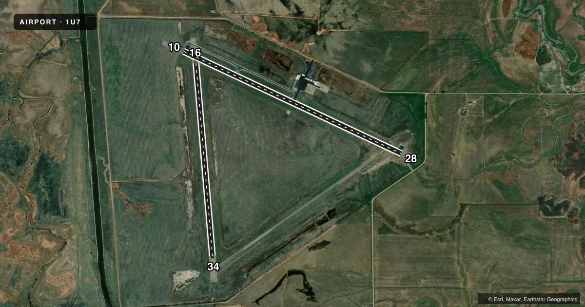
Runways & pattern
Full pagePattern entry · RWY 34
LEFT TRAFFIC| Runway | Heading (°M) | Length | Surface | Traffic |
|---|---|---|---|---|
| 10/28 | 104° / 284° | 5,728 ft | ASPH | Standard L |
| 16/34Favored | 164° / 344° | 4,590 ft | ASPH | Standard L |
Runway end performance
| End | TORA | TODA | ASDA | LDA | VGSI | Approach lights | Obstruction |
|---|---|---|---|---|---|---|---|
| 10 | — | — | — | — | PAPI 2-box left(3.5°) | — | 60', pline, 2500' from thr, 0' R of cntrln, slope 38 |
| 28 | — | — | — | — | PAPI 2-box left(3.5°) | — | 12', road, 500' from thr, 0' R of cntrln, slope 25 |
Declared distances in feet. TORA = takeoff run available, TODA = takeoff distance, ASDA = accelerate-stop, LDA = landing distance.
Airport sketch
Runways drawn to scale from FAA survey coordinates, rendered over satellite imagery. Not for navigation.
Approaches & charts
Services on the field
Fuel grades, oxygen, maintenance, ramp storage and lighting — as declared to the FAA by the airport operator.
Fuel & services
- Fuel
- 100LL
- Oxygen (bottled)
- Not available
- Oxygen (bulk)
- Not available
- Airframe repair
- Not available
- Power plant repair
- Not available
Ramp & ground
- Transient storage
- Tie-down
- Landing fee
- No fee published
- Customs
- Not available
- Lighting schedule
- SEE RMK
- Beacon schedule
- SS-SR
- Beacon
- White / Green (civil land)(WG)
- Wind indicator
- Lighted
- Segmented circle
- Yes
Fuel & FBOs
Cheapest 100LL and Jet A on the field and nearby. Always confirm with the FBO before taxi.
Airport notes
Surface conditions, obstructions, local procedures, lighting outages and other notes published with each FAA cycle.
General notes
- BIRDS ON & INVOF OF ARPT.
- REFLECTORS ON ALL TWYS AND APRONS.
- PARTIAL TWY 25 FT WIDE.
- NO SNOW REMOVAL RWY 16/34.
- FOR CD CTC SALT LAKE ARTCC AT 801-320-2568.
- COLD TEMPERATURE AIRPORT. ALTITUDE CORRECTION REQUIRED AT OR BELOW -22C.
Lighting notes
- ACTVT REIL RWY 10 & 28; MIRL RWY 10/28 - CTAF.
Fuel notes
- 100LL100 LL FUEL AVBL 24 HRS WITH CREDIT CARD SELF SVC.
Runway surface & condition
- 16/34NO SNOW REMOVAL RWY 16/34.
Approach & departure obstructions
- 16RUNWAY 16/34 HAS RUNWAY SIDE STRIPE MARKING
- 10PAPI UNSUBL BYD 8 NM FM THR DUE TO MOUNTAINOUS TRRN.
Other notes
- ESTABD PRIOR TO 15 MAY 1959.
- MANAGER208-223-0416 CELL, AVBL 24 HRS.
VFR map & nearby airports
VFR sectional. Tap any ICAO chip to open that airport.
Key facts · 1U7
Answer card- ICAO
- 1U7
- Name
- BEAR LAKE COUNTY
- Location
- PARIS, IDAHO
- Elevation
- 5,932.9 ft MSL
- Traffic pattern altitude
- 6,932.9 ft MSL (1,000 AGL)
- Control tower
- Non-towered (use CTAF)
- Total runways
- 2
- Longest runway
- 10/28 · 5,728 ft
- Published ILS approaches
- 0
- Published frequencies
- 2
- Magnetic variation
- 11°
- Current flight rules
- VFR
- Current wind
- 350° at 9 kt
- Favored runway now
- RWY 34
Bear Lake County Airport is in Paris, Idaho. The field elevation is 5,932.9 ft MSL. It has two asphalt runways. The longest is runway 10/28 at 5,728 ft. There is no control tower, so use CTAF 122.8 for local traffic calls. No ILS approaches are published here.
Pattern altitude is not published. For light piston operations, plan on 1,000 ft AGL unless the current Chart Supplement says otherwise. That puts you at about 6,933 ft MSL. The airport sits in mountain country, so expect terrain to matter on arrival, departure and when judging visual descent. PAPI on runway 10 is noted as unusable beyond 8 NM from the threshold because of the terrain. Runway end identifier lights and medium intensity runway lights are on runways 10 and 28. They are controlled by CTAF.
Bear Lake County Airport is the on-field FBO. It carries 100LL. The field also notes 24-hour self-serve fuel. The airport manager phone number is available 24 hours if you need local coordination. One operational point to plan for is that there is no snow removal on runway 16/34. Birds are also reported on and near the airport. For clearance delivery, contact Salt Lake ARTCC before departure.