METAR & TAF 0ID
0ID does not publish a METAR.
Showing the nearest reporting station: KLGU (LOGAN-CACHE) · 39.5 NM away. Conditions at 0ID may differ.
METAR · KLGU
Observed 23:51Z
KLGU 252351Z AUTO 19008KT 10SM CLR 37/09 A3001 RMK AO2 SLP095 T03670094 10372 20311 58021
- Wind
- 190° @ 8 kt
- Visibility
- 10 SM
- Temp / Dew
- 37°C / 9°C
- Altimeter
- 30.01 inHg
- Clouds
- CLR
- Density alt
- 8,821 ft
- Ceiling
- Unlimited
- Rules
- VFR
Airport info & contacts
Manager on record, flight service, ARTCC, attendance schedule and pattern altitude — published by the FAA and refreshed every 28 days.
Location
- From city
- 3 NM NW
- VFR sectional
- SALT LAKE CITY
- ARTCC
- ZLC · SALT LAKE CITY
- NOTAM facility
- HUF (NOTAM-D)
Airport manager
- Name
- W. E. RANCH, LLC
- Phone
- 801 440 6204
- Address
- 908 FRANCIS CIR, KAYSVILLE UT 84037
Flight service · Hours
- FSS BOI
- BOISE1-800-WX-BRIEF
- Attendance
- UNATTND
Frequencies
Tap any row to copy the frequency to your clipboard.
Runways & pattern
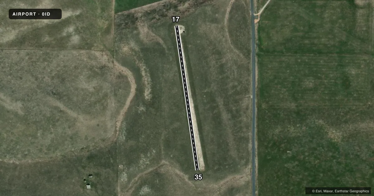
Full pagePattern entry · RWY 17
RIGHT TRAFFICAirport sketch
Runways drawn to scale from FAA survey coordinates, rendered over satellite imagery. Not for navigation.
Approaches & charts
Services on the field
Fuel grades, oxygen, maintenance, ramp storage and lighting — as declared to the FAA by the airport operator.
Fuel & services
- Fuel
- Not available
Ramp & ground
- Transient storage
- Tie-down
- Wind indicator
- Yes
- Segmented circle
- Yes
Fuel & FBOs
Cheapest 100LL and Jet A on the field and nearby. Always confirm with the FBO before taxi.
Airport notes
Surface conditions, obstructions, local procedures, lighting outages and other notes published with each FAA cycle.
General notes
- OWNER DESIRES ARPT BE CHARTED.
- RWY 17/35 LCTD ON A PLATEAU; SHARP DROP OFF NEAR BOTH RWY ENDS.
- NO WINTER MAINT; USE AT OWN RISK.
- CTN: PSBL LRG WILDLIFE ON OR INVOF RWY.
Other notes
- 17/35RWY SFC ROUGH DUE TO HVY LIVESTOCK TFC ON RWY.
VFR map & nearby airports
VFR sectional. Tap any ICAO chip to open that airport.
Key facts · 0ID
Answer card- ICAO
- 0ID
- Name
- W E RANCH
- Location
- THATCHER, IDAHO
- Elevation
- 5,075 ft MSL
- Traffic pattern altitude
- 6,075 ft MSL (1,000 AGL)
- Control tower
- Non-towered (use CTAF)
- Total runways
- 1
- Longest runway
- 17/35 · 1,350 ft
- Published ILS approaches
- 0
- Published frequencies
- 1
- Magnetic variation
- –
- Current flight rules
- VFR
- Current wind
- 190° at 8 kt
- Favored runway now
- RWY 17
W E RANCH sits in Thatcher, Idaho. Field elevation is 5,075 ft MSL. The airport has one runway. Runway 17/35 is 1,350 ft long on gravel. This is an uncontrolled field with no tower. CTAF is 122.9. No ILS approaches are published.
Pattern altitude is not published. Use the standard 1,000 ft AGL pattern unless the current Chart Supplement or local procedures say otherwise. That puts the light piston pattern at about 6,075 ft MSL. The field is on a plateau with a sharp drop off near both runway ends. That matters on takeoff and landing. Plan for a short strip at elevation. Density altitude can also be a factor here. No winter maintenance is provided. Use the runway with that in mind before you commit.
There are no on-field FBOs listed. If you need fuel or other services, contact the airport operator or the FBO directly by phone before you go. The owner wants the airport charted. For a first visit, brief the runway length, the gravel surface and the terrain at each end before you start up.