METAR & TAF U58
U58 does not publish a METAR.
Showing the nearest reporting station: KPIH (POCATELLO RGNL) · 36.2 NM away. Conditions at U58 may differ.
METAR · KPIH
Observed 11:53Z
KPIH 271153Z 22007KT 4SM HZ CLR 22/03 A3004 RMK AO2 SLP106 T02220033 10289 20217 51004
- Wind
- 220° @ 7 kt
- Visibility
- 4 SM
- Temp / Dew
- 22°C / 3°C
- Altimeter
- 30.04 inHg
- Clouds
- CLR
- Density alt
- 6,791 ft
- Ceiling
- Unlimited
- Rules
- MVFR
Airport info & contacts
Manager on record, flight service, ARTCC, attendance schedule and pattern altitude — published by the FAA and refreshed every 28 days.
Location
- From city
- 1 NM E
- VFR sectional
- SALT LAKE CITY
- ARTCC
- ZLC · SALT LAKE CITY
- NOTAM facility
- BOI (NOTAM-D)
Airport manager
- Name
- JOHN HYDE
- Phone
- 208-851-0348
- Address
- CITY OF DOWNEY, 15 S. MAIN ST., DOWNEY ID 83234
Flight service · Hours
- FSS BOI
- BOISE1-800-WX-BRIEF
- Attendance
- Unattended
Frequencies
Tap any row to copy the frequency to your clipboard.
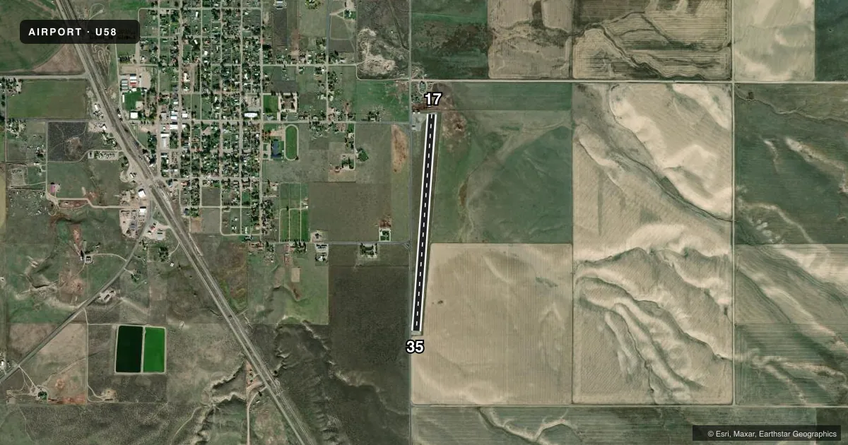
Runways & pattern
Full pagePattern entry · RWY 17
LEFT TRAFFICRunway end performance
| End | TORA | TODA | ASDA | LDA | VGSI | Approach lights | Obstruction |
|---|---|---|---|---|---|---|---|
| 17 | — | — | — | — | — | — | 25', tank, 450' from thr, 150' R of cntrln, slope 10 |
| 35 | — | — | — | — | — | — | 15', road, 200' from thr, 115' R of cntrln, slope 0 |
Declared distances in feet. TORA = takeoff run available, TODA = takeoff distance, ASDA = accelerate-stop, LDA = landing distance.
Airport sketch
Runways drawn to scale from FAA survey coordinates, rendered over satellite imagery. Not for navigation.
Approaches & charts
Services on the field
Fuel grades, oxygen, maintenance, ramp storage and lighting — as declared to the FAA by the airport operator.
Fuel & services
- Fuel
- Not available
- Oxygen (bottled)
- Not available
- Oxygen (bulk)
- Not available
- Airframe repair
- Not available
- Power plant repair
- Not available
- Other services
- AGRI
Ramp & ground
- Transient storage
- Tie-down
- Landing fee
- No fee published
- Lighting schedule
- SEE RMK
- Beacon schedule
- SEE RMK
- Beacon
- White / Green (civil land)(WG)
- Wind indicator
- Lighted
- Segmented circle
- Yes
Fuel & FBOs
Cheapest 100LL and Jet A on the field and nearby. Always confirm with the FBO before taxi.
Airport notes
Surface conditions, obstructions, local procedures, lighting outages and other notes published with each FAA cycle.
General notes
- FENCES ALL SIDES OF RWY & BTN PARL TO ROAD/RWY.
- RWY 35 FIRST 900 FT OF RWY IS CURVED 15 DEG TO THE E.
- FARM MACHINERY TO 20 FT HIGH MAY BE LCTD WITHIN 500 FT OF APCH TO RY 17.
- RAMP AND TWY ASPH POOR
- FOR CD CTC SALT LAKE ARTCC AT 801-320-2568.
Lighting notes
- ACTVT ROTG BCN - KEY 122.8 FIVE TIMES.
- ACTVT LIRL 17/35 - KEY 122.8 FIVE TIMES.
Runway surface & condition
- 17/35SOUTH 1000' OF RWY LIGHTS 1'-2' BELOW RWY SURFACE.
Approach & departure obstructions
- 17RWY 17 +3 FT FENCE 15 FT FM RY END & +3 FT FENCE 45 FT FM RY END; +7 FT PVT ROAD 30 FT FM RY END; +10 BLDG 75 FT R 100 FT FM RY END.
- 35RY 35 +15 FT ROAD 0 FT FROM RY END 120 FT L; +2 FT FENCE AT 15 FT ON CNTRLN.
- 1715 FT ROAD PARL TO RWY.
VFR map & nearby airports
VFR sectional. Tap any ICAO chip to open that airport.
Key facts · U58
Answer card- ICAO
- U58
- Name
- DOWNEY/HYDE MEML/
- Location
- DOWNEY, IDAHO
- Elevation
- 4,919 ft MSL
- Traffic pattern altitude
- 5,919 ft MSL (1,000 AGL)
- Control tower
- Non-towered (use CTAF)
- Total runways
- 1
- Longest runway
- 17/35 · 3,550 ft
- Published ILS approaches
- 0
- Published frequencies
- 1
- Magnetic variation
- 15°
- Current flight rules
- MVFR
- Current wind
- 220° at 7 kt
- Favored runway now
- RWY 17
Downey/Hyde Memorial Airport sits in Downey, Idaho. The field elevation is 4,919 ft MSL. It has one runway. Runway 17/35 is 3,550 ft asphalt, which is the longest runway on the field. There is no control tower. CTAF is 122.9.
No ILS approaches are published here. The pattern altitude is not published, so use the standard 1,000 ft AGL for light piston operations unless the current FAA Chart Supplement says otherwise. The airport has a few items that matter on a first visit. The ramp and taxiway asphalt is reported as poor. Farm machinery up to 20 feet high may be near the approach to Runway 17. Fences surround all sides of the runway. A road also runs parallel to the runway.
Lighting is pilot-controlled on 122.8. Key the mic five times to turn on the rotating beacon. Use the same method for the low intensity runway lights on 17/35. The south 1,000 feet of runway lights are 1 to 2 feet below the runway surface. Runway 35 has a curved first 900 feet that bends 15 degrees to the east. For clearance delivery, contact Salt Lake ARTCC at 801-320-2568. No on-field FBOs are listed, so verify fuel and services with the airport operator or call the field directly before arrival.