METAR & TAF KPIH
Current METAR
Observed 07:53Z
KPIH 270753Z 20008KT 7SM CLR 27/02 A3003 RMK AO2 SLP101 T02670022
- Wind
- 200° @ 8 kt
- Visibility
- 7 SM
- Temp / Dew
- 27°C / 2°C
- Altimeter
- 30.03 inHg
- Clouds
- CLR
- Density alt
- 6,824 ft
- Ceiling
- Unlimited
- Rules
- VFR
Airport info & contacts
Manager on record, flight service, ARTCC, attendance schedule and pattern altitude — published by the FAA and refreshed every 28 days.
Location
- From city
- 7 NM NW
- VFR sectional
- SALT LAKE CITY
- ARTCC
- ZLC · SALT LAKE CITY
- NOTAM facility
- PIH (NOTAM-D)
Airport manager
- Name
- ALAN EVANS
- Phone
- 208-234-6154
- Address
- P. O. BOX 4169, POCATELLO ID 83205-4169
Flight service · Hours
- FSS BOI
- BOISE1-800-WX-BRIEF
- Attendance
- 0600-2200
Frequencies
Tap any row to copy the frequency to your clipboard.
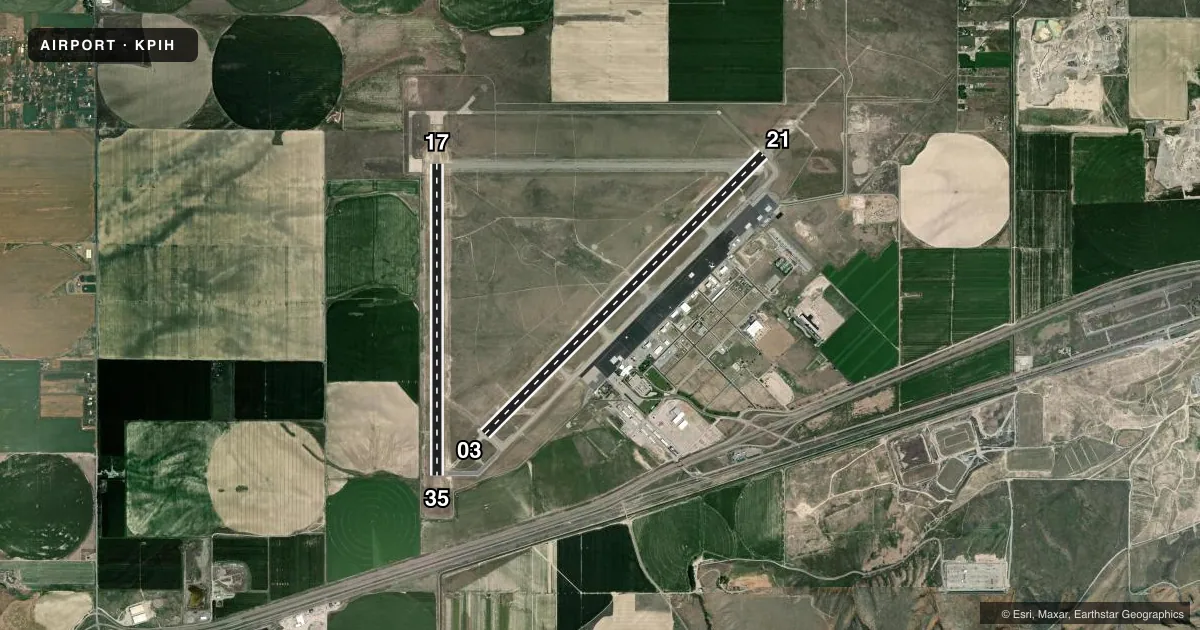
Runways & pattern
Full pagePattern entry · RWY 17
LEFT TRAFFIC| Runway | Heading (°M) | Length | Surface | Traffic |
|---|---|---|---|---|
| 03/21 | 31° / 211° | 9,059 ft | ASPH | Standard L |
| 17/35Favored | 166° / 346° | 7,150 ft | ASPH | Standard L |
Runway end performance
| End | TORA | TODA | ASDA | LDA | VGSI | Approach lights | Obstruction |
|---|---|---|---|---|---|---|---|
| 03 | 9,059' | 9,059' | 9,059' | 9,059' | PAPI 4-box left(3°) | — | — |
| 21 | 9,059' | 9,059' | 9,059' | 9,059' | PAPI 4-box left(3°) | MALSR | — |
| 17 | 7,150' | 7,150' | 7,150' | 7,150' | PAPI 4-box left(3°) | — | — |
| 35 | 7,150' | 7,150' | 7,150' | 7,150' | PAPI 4-box left(3°) | — | 42', pole, 2030' from thr, 50' R of cntrln, slope 43 |
Declared distances in feet. TORA = takeoff run available, TODA = takeoff distance, ASDA = accelerate-stop, LDA = landing distance.
Airport sketch
Runways drawn to scale from FAA survey coordinates, rendered over satellite imagery. Not for navigation.
Approaches & charts
ILS · 1
Services on the field
Fuel grades, oxygen, maintenance, ramp storage and lighting — as declared to the FAA by the airport operator.
Fuel & services
- Fuel
- 100LLA1A1+
- Oxygen (bottled)
- HIGH/LOW
- Airframe repair
- Major
- Power plant repair
- Major
- Other services
- AFRT,CARGO,CHTR,INSTR,RNTL
Ramp & ground
- Transient storage
- Tie-down
- Hangar
- Landing fee
- No fee published
- Customs
- Not available
- Lighting schedule
- SEE RMK
- Beacon schedule
- SS-SR
- Beacon
- White / Green (civil land)(WG)
- Wind indicator
- Lighted
- Segmented circle
- Yes
Fuel & FBOs
Cheapest 100LL and Jet A on the field and nearby. Always confirm with the FBO before taxi.
Airport notes
Surface conditions, obstructions, local procedures, lighting outages and other notes published with each FAA cycle.
General notes
- FLOCKS OF WATERFOWL IN VCNTY ARPT.
- RADIO CONTROLLED ACFT 1 MI E OF ARPT BLO 400 FT AGL.
- TWY 'G' HAS NO EDGE LIGHTS OR REFLECTORS, RESTRICTED TO DAY USE ONLY.
- AFLD COND UNMON 2330-0600 DLY EXC ACR OPNS AND 24-HR PPR 208-234-6154 OR 208-241-7949. ADNL FEES APPLY.
- FOR CD IF UNA TO CTC ON FSS FREQ, CTC SALT LAKE ARTCC AT 801-320-2568.
Lighting notes
- AFT ATCT CLSD ACTVT MALSR RWY 21; REIL RWY 17 & 03; PAPI RWY 21, 17 & 35; MIRL RWY 17/35; HIRL RWY 03/21 - CTAF. PAPI RWY 03 OPR CONSLY.
Fuel notes
- 100LLFBO MONITORS 122.95 & 123.0.
Runway surface & condition
- 03/21PCR VALUE: 615/F/B/X/T
- 17/35PCR VALUE: 615/F/B/X/T
Other notes
- 72 HRS PPR FOR UNSKED ACR OPNS WITH MORE THAN 30 PAX SEATS CALL ADMIN 208-234-6154 OR OPS 208-241-7949.
- 1FOR SERVICE OTHER TIMES CALL 1-800-350-0737
VFR map & nearby airports
VFR sectional. Tap any ICAO chip to open that airport.
Key facts · KPIH
Answer card- ICAO
- KPIH
- Name
- POCATELLO RGNL
- Location
- POCATELLO, IDAHO
- Elevation
- 4,451.9 ft MSL
- Traffic pattern altitude
- 5,451.9 ft MSL (1,000 AGL)
- Control tower
- Towered · 0600-2200
- Total runways
- 2
- Longest runway
- 03/21 · 9,059 ft
- Published ILS approaches
- 1
- Published frequencies
- 6
- Magnetic variation
- 14°
- Current flight rules
- VFR
- Current wind
- 200° at 8 kt
- Favored runway now
- RWY 17
Pocatello Rgnl sits in Pocatello, Idaho. The field elevation is 4,451.9 ft MSL. It has two asphalt runways. The longest is runway 03/21 at 9,059 ft. Tower service is published from 0600 to 2200. One ILS approach is available to runway 21. Pattern altitude is not published, so use the standard 1,000 ft AGL for light piston traffic unless the current Chart Supplement says otherwise.
Pocatello AvCenter is on the field. It carries 100LL, Jet A and Jet A Prist. The FBO monitors 122.95 and 123.0. Published remarks also note waterfowl in the area. That matters on departure and arrival. Taxiway G has no edge lights or reflectors. It is day use only. After tower close, runway 21 lighting can be activated by CTAF. REIL is published for runways 17 and 03. PAPI is published on 21, 17, 35 and 03. The airport also has overnight restrictions. Airfield condition is unmonitored from 2330 to 0600 daily except aircraft operations. Prior permission is required for that window. Check with the airport operator or the current FAA Chart Supplement before a late arrival or any special operation.