METAR & TAF KLGU
Current METAR
Observed 23:51Z
KLGU 252351Z AUTO 19008KT 10SM CLR 37/09 A3001 RMK AO2 SLP095 T03670094 10372 20311 58021
- Wind
- 190° @ 8 kt
- Visibility
- 10 SM
- Temp / Dew
- 37°C / 9°C
- Altimeter
- 30.01 inHg
- Clouds
- CLR
- Density alt
- 8,055 ft
- Ceiling
- Unlimited
- Rules
- VFR
Airport info & contacts
Manager on record, flight service, ARTCC, attendance schedule and pattern altitude — published by the FAA and refreshed every 28 days.
Location
- From city
- 3 NM NW
- VFR sectional
- SALT LAKE CITY
- ARTCC
- ZLC · SALT LAKE CITY
- NOTAM facility
- LGU (NOTAM-D)
Airport manager
- Name
- BOB LOW
- Phone
- 435-755-1750
- Address
- 199 N. MAIN, LOGAN UT 84321
Flight service · Hours
- FSS CDC
- CEDAR CITY1-800-WX-BRIEF
- Attendance
- 0800-1900
Frequencies
Tap any row to copy the frequency to your clipboard.
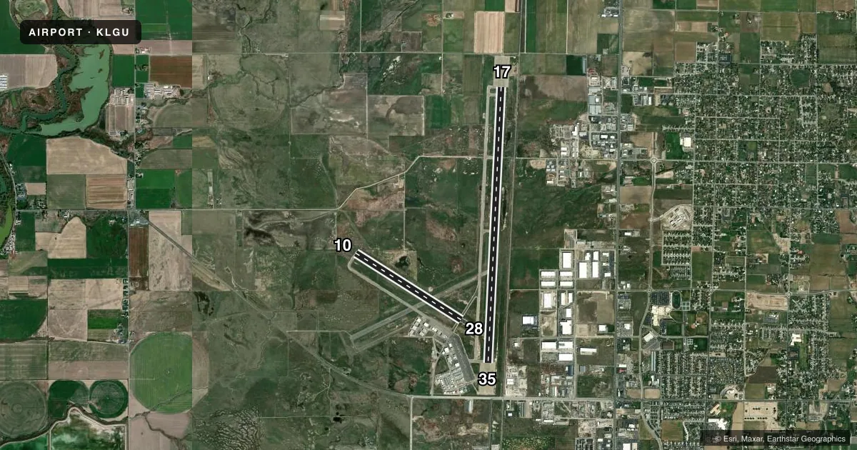
Runways & pattern
Full pagePattern entry · RWY 17
LEFT TRAFFIC| Runway | Heading (°M) | Length | Surface | Traffic |
|---|---|---|---|---|
| 17/35Favored | 172° / 352° | 9,020 ft | ASPH | Standard L |
| 10/28 | 111° / 291° | 4,075 ft | ASPH | Standard L |
Runway end performance
| End | TORA | TODA | ASDA | LDA | VGSI | Approach lights | Obstruction |
|---|---|---|---|---|---|---|---|
| 17 | 9,020' | 9,020' | 9,020' | 9,020' | PAPI 2-box left(3°) | MALSR | 23', rr, 555' from thr, 560' R of cntrln, slope 15 |
| 35 | 9,020' | 9,020' | 9,020' | 9,020' | PAPI 2-box left(3°) | — | — |
| 10 | 4,075' | 4,075' | — | — | — | — | — |
| 28 | 4,075' | 4,075' | — | — | — | — | 23', rr, 485' from thr, slope 12 |
Declared distances in feet. TORA = takeoff run available, TODA = takeoff distance, ASDA = accelerate-stop, LDA = landing distance.
Airport sketch
Runways drawn to scale from FAA survey coordinates, rendered over satellite imagery. Not for navigation.
Approaches & charts
ILS · 1
Services on the field
Fuel grades, oxygen, maintenance, ramp storage and lighting — as declared to the FAA by the airport operator.
Fuel & services
- Fuel
- 100LLA
- Oxygen (bulk)
- HIGH/LOW
- Airframe repair
- Major
- Power plant repair
- Major
- Other services
- CHTR,INSTR,RNTL
Ramp & ground
- Transient storage
- Tie-down
- Hangar
- Landing fee
- Yes
- Customs
- Not available
- Lighting schedule
- SEE RMK
- Beacon schedule
- SS-SR
- Beacon
- White / Green (civil land)(WG)
- Wind indicator
- Lighted
- Segmented circle
- Yes
Fuel & FBOs
Cheapest 100LL and Jet A on the field and nearby. Always confirm with the FBO before taxi.
Airport notes
Surface conditions, obstructions, local procedures, lighting outages and other notes published with each FAA cycle.
General notes
- BIRDS ON & INVOF ARPT SPRING & SUMMER.
- COLD TEMPERATURE AIRPORT. ALTITUDE CORRECTION REQUIRED AT OR BELOW -14C.
- FLT TRNG INVOF ARPT.
- FOR CD CTC SALT LAKE ARTCC AT 801-320-2568.
Lighting notes
- ACTVT MALSR RWY 17; REIL RWY 35; PAPI RWY 17 & 35; HIRL RWY 17/35 - CTAF.
Fuel notes
- 100LLAVBL H24 WITH CREDIT CARD; AFT HR - 435-753-2221/435-752-5955.
Runway surface & condition
- 17/35PCR VALUE: 550/F/D/X/T
- 10/28DALGT USE ONLY.
Other notes
- LANDING FEE, CTC AMGR FOR MORE INFO.
VFR map & nearby airports
VFR sectional. Tap any ICAO chip to open that airport.
Key facts · KLGU
Answer card- ICAO
- KLGU
- Name
- LOGAN-CACHE
- Location
- LOGAN, UTAH
- Elevation
- 4,456.9 ft MSL
- Traffic pattern altitude
- 5,456.9 ft MSL (1,000 AGL)
- Control tower
- Non-towered (use CTAF)
- Total runways
- 2
- Longest runway
- 17/35 · 9,020 ft
- Published ILS approaches
- 1
- Published frequencies
- 2
- Magnetic variation
- 11°
- Current flight rules
- VFR
- Current wind
- 190° at 8 kt
- Favored runway now
- RWY 17
Logan-Cache Airport sits in Logan, Utah. Field elevation is 4,456.9 ft MSL. The airport has two asphalt runways. The longest is runway 17/35 at 9,020 ft. There is no control tower, so use CTAF 122.8 for airport traffic and UNICOM on the same frequency. One ILS is published for runway 17. Pattern altitude is not published in the facts, so plan on the standard 1,000 ft AGL for light piston operations unless the current FAA Chart Supplement says otherwise.
Leading Edge Aviation is on the field. It carries 100LL, Jet A and Jet A Prist. 100LL is available 24 hours with credit card. After hours, call the numbers in the Chart Supplement or the FBO directly. Runway 10/28 is daylight use only. Runway 17/35 has MALSR for 17, REIL for 35, PAPI on both ends and high intensity lighting on both ends. Flight training is conducted in the area. Expect pattern traffic. Birds are also reported on and near the airport in spring and summer. This is a cold temperature airport. Altitude correction is required at or below minus 14 degrees Celsius. For clearance delivery, contact Salt Lake ARTCC before departure.