METAR & TAF KOGD
Current METAR
Observed 11:53Z
KOGD 271153Z AUTO 13004KT 10SM CLR 30/08 A3000 RMK AO2 SLP078 T03000078 10339 20289 53003 $
- Wind
- 130° @ 4 kt
- Visibility
- 10 SM
- Temp / Dew
- 30°C / 8°C
- Altimeter
- 30.00 inHg
- Clouds
- CLR
- Density alt
- 7,247 ft
- Ceiling
- Unlimited
- Rules
- VFR
Airport info & contacts
Manager on record, flight service, ARTCC, attendance schedule and pattern altitude — published by the FAA and refreshed every 28 days.
Location
- From city
- 3 NM SW
- VFR sectional
- SALT LAKE CITY
- ARTCC
- ZLC · SALT LAKE CITY
- NOTAM facility
- OGD (NOTAM-D)
Airport manager
- Name
- BRIAN CONDIE
- Phone
- 801-629-8223
- Address
- 3909 AIRPORT ROAD, OGDEN UT 84405
Flight service · Hours
- FSS CDC
- CEDAR CITY1-800-WX-BRIEF
- Attendance
- ALL
Frequencies
Tap any row to copy the frequency to your clipboard.
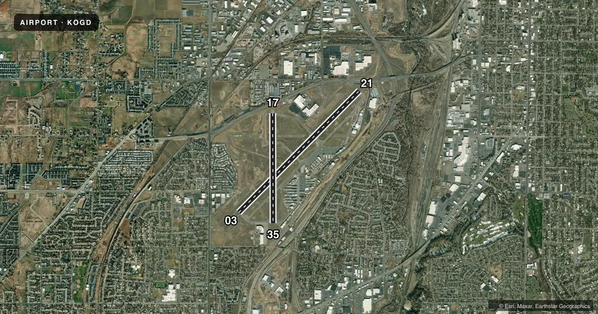
Runways & pattern
Full pagePattern entry · RWY 17
RIGHT TRAFFIC| Runway | Heading (°M) | Length | Surface | Traffic |
|---|---|---|---|---|
| 03/21 | 33° / 213° | 8,107 ft | ASPH | 21 R |
| 17/35Favored | 168° / 348° | 5,195 ft | ASPH | 17 R |
Runway end performance
| End | TORA | TODA | ASDA | LDA | VGSI | Approach lights | Obstruction |
|---|---|---|---|---|---|---|---|
| 03 | 8,107' | 8,107' | 7,253' | 7,253' | PAPI 4-box left(3°) | MALS | 54', trees, 2425' from thr, 305' R of cntrln, slope 44 |
| 21 | 8,107' | 8,107' | 8,107' | 7,253' | PAPI 4-box left(3°) | — | 24', pole, 1017' from thr, 161' R of cntrln, slope 34 |
| 17 | 5,195' | 5,195' | 5,195' | 5,195' | PAPI 4-box left(3°) | — | 3', road, 210' from thr, 125' R of cntrln, slope 3 |
| 35 | 5,195' | 5,195' | 5,195' | 5,195' | PAPI 4-box left(3°) | — | 50', sign, 1200' from thr, 200' R of cntrln, slope 20 |
Declared distances in feet. TORA = takeoff run available, TODA = takeoff distance, ASDA = accelerate-stop, LDA = landing distance.
Airport sketch
Runways drawn to scale from FAA survey coordinates, rendered over satellite imagery. Not for navigation.
Approaches & charts
ILS · 1
Services on the field
Fuel grades, oxygen, maintenance, ramp storage and lighting — as declared to the FAA by the airport operator.
Fuel & services
- Fuel
- 100100LLA1+J
- Oxygen (bulk)
- HIGH/LOW
- Airframe repair
- Major
- Power plant repair
- Major
- Other services
- AGRI,AVNCS,CHTR,INSTR,PAJA,RNTL,SALES,SURV
Ramp & ground
- Transient storage
- Tie-down
- Hangar
- Landing fee
- Yes
- Customs
- Not available
- Lighting schedule
- SEE RMK
- Beacon schedule
- SS-SR
- Beacon
- White / Green (civil land)(WG)
- Wind indicator
- Lighted
- Segmented circle
- Yes
Fuel & FBOs
Cheapest 100LL and Jet A on the field and nearby. Always confirm with the FBO before taxi.
Airport notes
Surface conditions, obstructions, local procedures, lighting outages and other notes published with each FAA cycle.
General notes
- MULT & PRAC APCH NA. FSL 2200-0700.
- PAJA NE PTN OF ARPT E OF TWY A.
- MIL OPS 5700-6300 FT MSL OVR ARPT ENRT TO HILL AFB.
- FOR CD WHEN ATCT IS CLSD CTC SLC APCH AT 801-325-9670.
- SFC COND UNMON MON-FRI 1700-0800, SAT/SUN UNMON EXC AIR ACR OPS.
- RWY 3/21, A, B, C, D, E, TRML, AVFLIGHT & SKYSHARE RAMPS AVBL TO ACR.
- ARPT OPS MNTS 118.7 WHEN TWR CLSD.
Lighting notes
- WHEN ATCT CLSD ACTVT MALS RWY 03; REIL RWY 17 & 35; PAPI RWY 03 & 21, 17 & 35; HIRL RWY 03/21; MIRL RWY 17/35; TWY LGTS - CTAF.
Fuel notes
- JJP4
Runway surface & condition
- 03/21ST 152
- 03/21PCR VALUE: 500/F/B/X/T
Approach & departure obstructions
- 2117 FT ROAD 350 FT FM THR.
- 21APCH SLOPE 77:1 TO DTHR.
Other notes
- CLSD TO ACFT OPNS WITH MORE THAN 30 PSGR SEATS EXCP PPR, MINIMUM 60 MIN NOTICE RQRD, CALL AMGR 801-629-8223.
- GTR THAN 12500 LB.
- TPA 5200 MSL REQD DUE TO INTERFACING TFC FM HILL AFB.
VFR map & nearby airports
VFR sectional. Tap any ICAO chip to open that airport.
Key facts · KOGD
Answer card- ICAO
- KOGD
- Name
- OGDEN-HINCKLEY
- Location
- OGDEN, UTAH
- Elevation
- 4,472.5 ft MSL
- Traffic pattern altitude
- 5,472.5 ft MSL (1,000 AGL)
- Control tower
- Towered · 0700-2000
- Total runways
- 2
- Longest runway
- 03/21 · 8,107 ft
- Published ILS approaches
- 1
- Published frequencies
- 8
- Magnetic variation
- 11°
- Current flight rules
- VFR
- Current wind
- 130° at 4 kt
- Favored runway now
- RWY 17
Ogden-Hinckley Airport sits in Ogden, Utah at 4,472.5 ft MSL. It has two asphalt runways. The longest is 8,107 ft on 03/21. The tower is open daily from 0700 to 2000. One ILS is published for runway 03. The pattern altitude is 5,200 ft MSL, which is 1,000 ft AGL for light piston traffic.
This is a field where altitude and nearby traffic matter. The published remarks call out military traffic between 5,700 and 6,300 ft MSL en route to Hill Air Force Base. The airport also uses a higher pattern altitude than the usual 1,000 ft AGL standard. That is worth planning for before you join the pattern. Runway 21 has a noted obstruction issue near the threshold. The approach slope is 77 to 1 to the displaced threshold, with a 17 ft road 350 ft from the threshold.
Avflight Ogden and Mountain Valley Aviation are on the field. Both carry 100LL and Jet A. When the tower is closed, clearance delivery goes through Salt Lake City Approach. The airport also notes that surface condition is unmonitored during some off-hours. Check the current FAA Chart Supplement and call the airport operator or FBO directly if you need current operational details before arrival.