METAR & TAF KRIF
Current METAR
Observed 06:34Z
KRIF 270634Z AUTO VRB03KT 10SM BKN046 OVC050 24/13 A3018 RMK AO2
- Wind
- VAR @ 3 kt
- Visibility
- 10 SM
- Temp / Dew
- 24°C / 13°C
- Altimeter
- 30.18 inHg
- Clouds
- OVC
- Density alt
- 7,352 ft
- Ceiling
- 4,600 ft AGL
- Rules
- VFR
Airport info & contacts
Manager on record, flight service, ARTCC, attendance schedule and pattern altitude — published by the FAA and refreshed every 28 days.
Location
- From city
- 1 NM SW
- VFR sectional
- LAS VEGAS
- ARTCC
- ZLC · SALT LAKE CITY
- NOTAM facility
- CDC (NOTAM-D)
Airport manager
- Name
- ADAM ROBINSON
- Phone
- (435) 896-9413
- Address
- 702 AIR TERMINAL WAY, RICHFIELD UT 84701-0191
Flight service · Hours
- FSS CDC
- CEDAR CITY1-800-WX-BRIEF
- Attendance
- 0800-1700
Frequencies
Tap any row to copy the frequency to your clipboard.
Runways & pattern
Full pagePattern entry · RWY 01
RIGHT TRAFFICRunway end performance
| End | TORA | TODA | ASDA | LDA | VGSI | Approach lights | Obstruction |
|---|---|---|---|---|---|---|---|
| 01 | — | — | — | — | PAPI 2-box left(3°) | — | — |
| 19 | — | — | — | — | PAPI 2-box left(3°) | — | — |
Declared distances in feet. TORA = takeoff run available, TODA = takeoff distance, ASDA = accelerate-stop, LDA = landing distance.
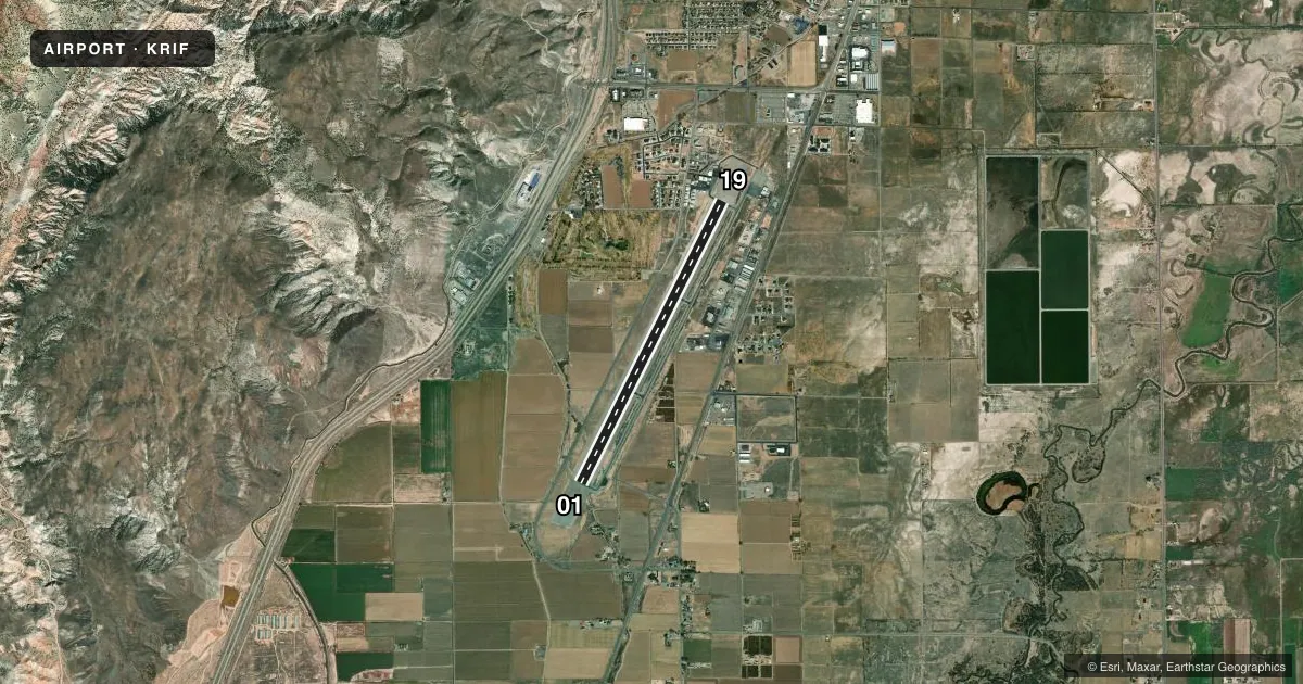
Airport sketch
Runways drawn to scale from FAA survey coordinates, rendered over satellite imagery. Not for navigation.
Approaches & charts
Services on the field
Fuel grades, oxygen, maintenance, ramp storage and lighting — as declared to the FAA by the airport operator.
Fuel & services
- Fuel
- 100LLAA+
- Oxygen (bottled)
- Not available
- Oxygen (bulk)
- Not available
- Airframe repair
- Major
- Power plant repair
- Major
- Other services
- AMB
Ramp & ground
- Transient storage
- Tie-down
- Landing fee
- No fee published
- Customs
- Not available
- Lighting schedule
- SEE RMK
- Beacon schedule
- SS-SR
- Beacon
- White / Green (civil land)(WG)
- Wind indicator
- Lighted
- Segmented circle
- Yes
Fuel & FBOs
Cheapest 100LL and Jet A on the field and nearby. Always confirm with the FBO before taxi.
Airport notes
Surface conditions, obstructions, local procedures, lighting outages and other notes published with each FAA cycle.
General notes
- COLD TEMPERATURE AIRPORT. ALTITUDE CORRECTION REQUIRED AT OR BELOW -11C.
- FOR CD IF UNA TO CTC ON FSS FREQ, CTC SALT LAKE ARTCC AT 801-320-2568.
- FBO/FUEL LCTD NE RWY 19.
Lighting notes
- ACTVT REIL RWY 01 & 19; MIRL RWY 01/19 - CTAF.
Fuel notes
- 100LLAFT HRS FUEL CALL 435-896-3053.
VFR map & nearby airports
VFR sectional. Tap any ICAO chip to open that airport.
Key facts · KRIF
Answer card- ICAO
- KRIF
- Name
- RICHFIELD MUNI
- Location
- RICHFIELD, UTAH
- Elevation
- 5,318 ft MSL
- Traffic pattern altitude
- 6,318 ft MSL (1,000 AGL)
- Control tower
- Non-towered (use CTAF)
- Total runways
- 1
- Longest runway
- 01/19 · 7,100 ft
- Published ILS approaches
- 0
- Published frequencies
- 2
- Magnetic variation
- 13°
- Current flight rules
- VFR
- Current wind
- 000° at 3 kt
- Favored runway now
- RWY 01
Richfield Muni sits in Richfield, Utah. Field elevation is 5,318 ft MSL. The airport has one runway. Runway 01/19 is 7,100 ft long with an asphalt surface. There is no control tower. CTAF and UNICOM are both 122.8. No ILS approaches are published here.
Pattern altitude is not published. Use the standard 1,000 ft AGL for light piston traffic unless the current Chart Supplement says otherwise. That puts the pattern at 6,318 ft MSL based on the field elevation. Verify before you fly. The airport is a cold temperature field. Altitude correction is required at or below minus 11 degrees Celsius. That matters here because the field already sits above 5,000 ft MSL.
Richfield Municipal Airport is on the field. It carries 100LL and Jet A. The FBO and fuel are northeast of runway 19. After hours 100LL fuel is available by phone. Runway end identifier lights are on runways 01 and 19. Medium intensity runway lights are also on 01 and 19. They are controlled on CTAF. If you need IFR clearance and cannot reach Flight Service, the published remark says to contact Salt Lake Air Route Traffic Control Center. Expect a non-towered mountain airport profile with density altitude considerations in warm weather. Expect winter performance changes in cold weather.