METAR & TAF 1L1
1L1 does not publish a METAR.
Showing the nearest reporting station: KSGU (ST GEORGE RGNL) · 62.6 NM away. Conditions at 1L1 may differ.
METAR · KSGU
Observed 12:56Z
KSGU 271256Z AUTO 09005KT 9SM CLR 27/12 A2999 RMK AO2 SLP112 T02670117
- Wind
- 090° @ 5 kt
- Visibility
- 9 SM
- Temp / Dew
- 27°C / 12°C
- Altimeter
- 29.99 inHg
- Clouds
- CLR
- Density alt
- 7,344 ft
- Ceiling
- Unlimited
- Rules
- VFR
Airport info & contacts
Manager on record, flight service, ARTCC, attendance schedule and pattern altitude — published by the FAA and refreshed every 28 days.
Location
- From city
- 2 NM W
- VFR sectional
- LAS VEGAS
- Pattern altitude
- 800 ft AGL · 5,631 ft MSL
- ARTCC
- ZLA · LOS ANGELES
- NOTAM facility
- RNO (NOTAM-D)
Airport manager
- Name
- WENDY RUDDER
- Phone
- (702) 449-2418
- Address
- P.O. BOX 509, ALAMO NV 89001
Flight service · Hours
- FSS RNO
- RENO1-800-WX-BRIEF
- Attendance
- UNATTND
Frequencies
Tap any row to copy the frequency to your clipboard.
Runways & pattern
Full pagePattern entry · RWY 35
LEFT TRAFFICRunway end performance
| End | TORA | TODA | ASDA | LDA | VGSI | Approach lights | Obstruction |
|---|---|---|---|---|---|---|---|
| 17 | — | — | — | — | — | — | 80', hill, 1600' from thr, 0' R of cntrln, slope 17 |
Declared distances in feet. TORA = takeoff run available, TODA = takeoff distance, ASDA = accelerate-stop, LDA = landing distance.
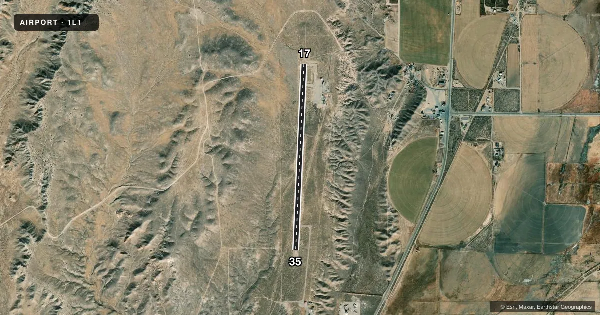
Airport sketch
Runways drawn to scale from FAA survey coordinates, rendered over satellite imagery. Not for navigation.
Approaches & charts
Services on the field
Fuel grades, oxygen, maintenance, ramp storage and lighting — as declared to the FAA by the airport operator.
Fuel & services
- Fuel
- 100LL
- Oxygen (bottled)
- Not available
- Oxygen (bulk)
- Not available
- Airframe repair
- Not available
- Power plant repair
- Not available
Ramp & ground
- Transient storage
- Tie-down
- Landing fee
- No fee published
- Customs
- Not available
- Lighting schedule
- SEE RMK
- Beacon schedule
- SS-SR
- Beacon
- White / Green (civil land)(WG)
- Wind indicator
- Yes
- Segmented circle
- Yes
Fuel & FBOs
Cheapest 100LL and Jet A on the field and nearby. Always confirm with the FBO before taxi.
Airport notes
Surface conditions, obstructions, local procedures, lighting outages and other notes published with each FAA cycle.
General notes
- FOR CD CTC NELLIS APP AT 702-652-4172.
Lighting notes
- ACTVT MIRL RWY 17/35 - CTAF.
Approach & departure obstructions
- 175 FT BRUSH IN RSA.
- 355 FT BRUSH IN RSA.
- 17SFC MARKS WEATHERED.
- 35SFC MARKS WEATHERED.
VFR map & nearby airports
VFR sectional. Tap any ICAO chip to open that airport.
Key facts · 1L1
Answer card- ICAO
- 1L1
- Name
- LINCOLN COUNTY
- Location
- PANACA, NEVADA
- Elevation
- 4,831 ft MSL
- Traffic pattern altitude
- 5,631 ft MSL (800 AGL)
- Control tower
- Non-towered (use CTAF)
- Total runways
- 1
- Longest runway
- 17/35 · 4,606 ft
- Published ILS approaches
- 0
- Published frequencies
- 2
- Magnetic variation
- 14°
- Current flight rules
- VFR
- Current wind
- 090° at 5 kt
- Favored runway now
- RWY 35
Lincoln County Airport (1L1) sits in Panaca, Nevada. Field elevation is 4,831 ft MSL. The airport has one runway. Runway 17/35 is 4,606 ft long with an asphalt surface. The field is not towered. CTAF and UNICOM are both 122.8. Pattern altitude is 800 ft AGL, which is 5,631 ft MSL.
No ILS approaches are published here. The on-field FBO is Lincoln County Airport. It carries AVGAS 100LL. Call ahead at (702) 449-2418 if you need current fuel or ramp details. Published remarks matter here. There is 5 ft brush in the runway safety area near both runway ends. Surface markings on both runway 17 and runway 35 are weathered. Medium intensity runway lights on 17/35 activate on the CTAF.
This is a high-elevation strip, so plan for performance accordingly. The airport is uncontrolled. Use standard traffic discipline and watch for local traffic on CTAF. For clearance delivery, contact Nellis Approach at 702-652-4172. If you are flying in IFR or need current operational details, check the current FAA Chart Supplement before departure.