METAR & TAF KLWL
KLWL does not publish a METAR.
Showing the nearest reporting station: KEKO (ELKO RGNL) · 43.1 NM away. Conditions at KLWL may differ.
METAR · KEKO
Observed 12:56Z
KEKO 271256Z AUTO 00000KT 10SM CLR 17/M02 A3011 RMK AO2 SLP129 T01721022
- Wind
- 000° @ 0 kt
- Visibility
- 10 SM
- Temp / Dew
- 17°C / -2°C
- Altimeter
- 30.11 inHg
- Clouds
- CLR
- Density alt
- 7,158 ft
- Ceiling
- Unlimited
- Rules
- VFR
Airport info & contacts
Manager on record, flight service, ARTCC, attendance schedule and pattern altitude — published by the FAA and refreshed every 28 days.
Location
- From city
- 2 NM NE
- VFR sectional
- SALT LAKE CITY
- ARTCC
- ZLC · SALT LAKE CITY
- NOTAM facility
- RNO (NOTAM-D)
Airport manager
- Name
- JASON PENGELLY
- Phone
- 775-752-3355
- Address
- PO BOX 366, 451 UNION STREET, WELLS NV 89835
Flight service · Hours
- FSS RNO
- RENO1-800-WX-BRIEF
- Attendance
- Unattended
Frequencies
Tap any row to copy the frequency to your clipboard.
Runways & pattern
Full pagePattern entry · RWY 09
RIGHT TRAFFIC| Runway | Heading (°M) | Length | Surface | Traffic |
|---|---|---|---|---|
| 09/27 | 84° / 264° | 5,508 ft | ASPH | 09 R |
| 01/19 | 10° / 190° | 2,681 ft | DIRT-GRVL | 01 R |
Runway end performance
| End | TORA | TODA | ASDA | LDA | VGSI | Approach lights | Obstruction |
|---|---|---|---|---|---|---|---|
| 01 | — | — | — | — | — | — | 30', bldg, 600' from thr, 300' R of cntrln, slope 20 |
| 19 | — | — | — | — | — | — | 11', hill, 300' from thr, 0' R of cntrln, slope 27 |
Declared distances in feet. TORA = takeoff run available, TODA = takeoff distance, ASDA = accelerate-stop, LDA = landing distance.
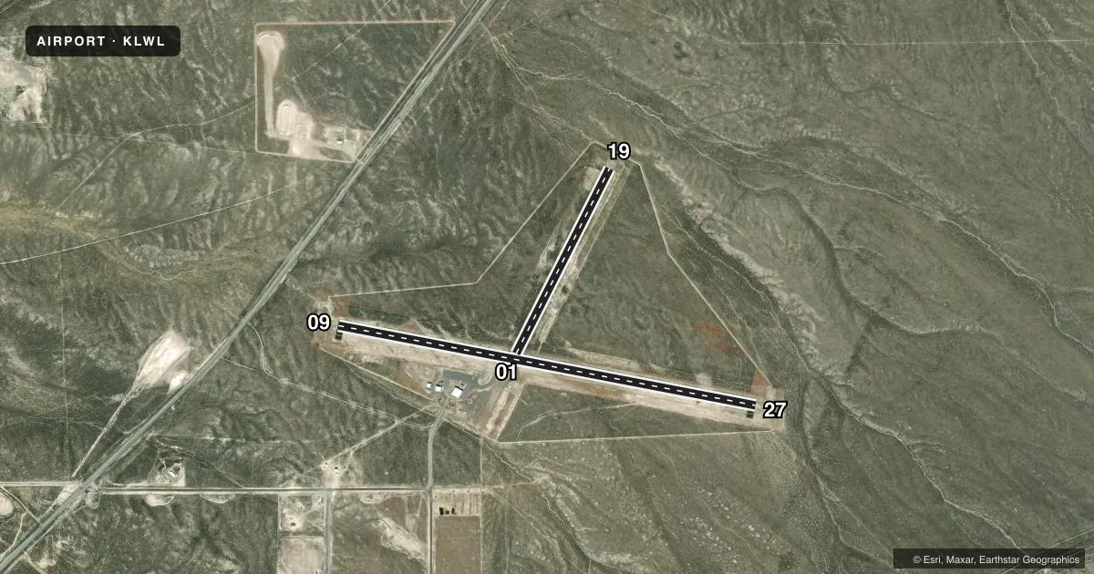
Airport sketch
Runways drawn to scale from FAA survey coordinates, rendered over satellite imagery. Not for navigation.
Approaches & charts
Services on the field
Fuel grades, oxygen, maintenance, ramp storage and lighting — as declared to the FAA by the airport operator.
Fuel & services
- Fuel
- 100LLA
- Oxygen (bottled)
- Not available
- Oxygen (bulk)
- Not available
- Other services
- AMB
Ramp & ground
- Transient storage
- Tie-down
- Landing fee
- No fee published
- Customs
- Not available
- Lighting schedule
- SEE RMK
- Beacon schedule
- SS-SR
- Beacon
- White / Green (civil land)(WG)
- Wind indicator
- Lighted
- Segmented circle
- Yes
Fuel & FBOs
Cheapest 100LL and Jet A on the field and nearby. Always confirm with the FBO before taxi.
Airport notes
Surface conditions, obstructions, local procedures, lighting outages and other notes published with each FAA cycle.
General notes
- FONE AVBL LCTD AT HNGR.
- RWY 01/19 NO LINE OF SIGHT BETWEEN RWY ENDS.
- MTNS N & S QUADS.
- SNOW REMOVAL SVCS DURG DALGT ONLY EXCP BY PRIOR ARNGMT CALL 775-777-7300.
- ULTRALIGHT ACTVTY ON & INVOF ARPT.
- FIREFIGHTING ACFT ACT ON AND INVOF ARPT.
- USE CTN DRG TKOF AND LND - WIND CIRCULATIONS AND THERMALS IN THE AREA.
- FOR CD IF UNA TO CTC ON FSS FREQ, CTC SALT LAKE ARTCC AT 801-320-2568.
- SEGMENTED CIRC TFC PAT ARMS ARE SCATTERED AND DO NOT REFLECT RIGHT TRAFFIC WHERE DSGND.
Lighting notes
- ACTVT MIRL RWY 09/27 - CTAF.
Runway surface & condition
- 09/27CENTER 75 FT STRESSED FOR 25000 LBS SNGL WHEEL; REMAINDER OF 150 FT WIDTH IS 11500 LBS SNGL WHEEL.
Other notes
- MANAGERCITY MGR.
VFR map & nearby airports
VFR sectional. Tap any ICAO chip to open that airport.
Key facts · KLWL
Answer card- ICAO
- KLWL
- Name
- WELLS MUNI/HARRIET FLD
- Location
- WELLS, NEVADA
- Elevation
- 5,769 ft MSL
- Traffic pattern altitude
- 6,769 ft MSL (1,000 AGL)
- Control tower
- Non-towered (use CTAF)
- Total runways
- 2
- Longest runway
- 09/27 · 5,508 ft
- Published ILS approaches
- 0
- Published frequencies
- 2
- Magnetic variation
- 17°
- Current flight rules
- VFR
- Current wind
- 000° at 0 kt
- Favored runway now
- –
Wells Muni/Harriet Fld sits in Wells, Nevada at 5,769 ft MSL. It has two runways. The longest is 09/27 at 5,508 ft. Runway 01/19 is 2,681 ft of dirt and gravel. There is no control tower. CTAF and UNICOM are both 122.8.
No ILS approaches are published here. Pattern altitude is not published, so use standard traffic pattern planning unless the current FAA Chart Supplement says otherwise. The on-field FBO is Wells Municipal Airport. It carries 100LL and Jet A. Call the FBO directly at (775) 752-3120 for current service details.
This is a high-elevation field with mountains in the north and south quadrants. Expect density altitude to matter, especially on warm days. The published remarks also call out thermals, wind circulations and firefighting aircraft in the area. Runway 01/19 has no line of sight between the ends. Segmented circle arms are scattered, so do not rely on them alone for right traffic indications. Runway 09/27 has medium intensity lights that are activated by CTAF. If you need clearance delivery and cannot reach Flight Service, contact Salt Lake ARTCC at 801-320-2568.