METAR & TAF U03
U03 does not publish a METAR.
Showing the nearest reporting station: KTWF (JOSLIN FLD/MAGIC VALLEY RGNL) · 15.5 NM away. Conditions at U03 may differ.
METAR · KTWF
Observed 22:53Z
KTWF 252253Z 09004KT 10SM FEW110 36/05 A2997 RMK AO2 LTG DSNT S AND SW SLP073 T03560050
- Wind
- 090° @ 4 kt
- Visibility
- 10 SM
- Temp / Dew
- 36°C / 5°C
- Altimeter
- 29.97 inHg
- Clouds
- FEW
- Density alt
- 7,000 ft
- Ceiling
- Unlimited
- Rules
- VFR
Airport info & contacts
Manager on record, flight service, ARTCC, attendance schedule and pattern altitude — published by the FAA and refreshed every 28 days.
Location
- From city
- 2 NM W
- VFR sectional
- SALT LAKE CITY
- ARTCC
- ZLC · SALT LAKE CITY
- NOTAM facility
- BOI (NOTAM-D)
Airport manager
- Name
- NEIL RING
- Phone
- 208-961-6539
- Address
- 203 BROADWAY NORTH, BUHL ID 83316
Flight service · Hours
- FSS BOI
- BOISE1-800-WX-BRIEF
- Attendance
- 0830-1700
Frequencies
Tap any row to copy the frequency to your clipboard.
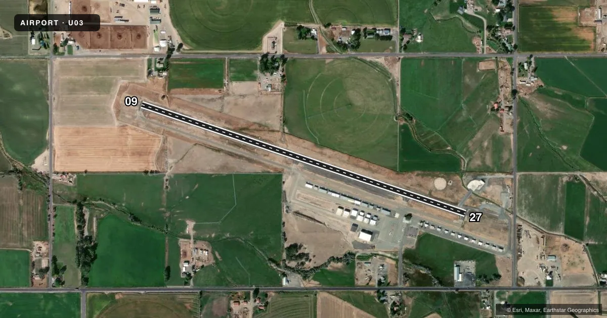
Runways & pattern
Full pagePattern entry · RWY 09
LEFT TRAFFICRunway end performance
| End | TORA | TODA | ASDA | LDA | VGSI | Approach lights | Obstruction |
|---|---|---|---|---|---|---|---|
| 09 | — | — | — | — | — | — | 5', fence, 300' from thr, 0' R of cntrln, slope 20 |
| 27 | — | — | — | — | — | — | 15', road, 525' from thr, 0' R of cntrln, slope 21 |
Declared distances in feet. TORA = takeoff run available, TODA = takeoff distance, ASDA = accelerate-stop, LDA = landing distance.
Airport sketch
Runways drawn to scale from FAA survey coordinates, rendered over satellite imagery. Not for navigation.
Approaches & charts
Services on the field
Fuel grades, oxygen, maintenance, ramp storage and lighting — as declared to the FAA by the airport operator.
Fuel & services
- Fuel
- 100LLMOGAS
- Oxygen (bottled)
- Not available
- Oxygen (bulk)
- Not available
- Airframe repair
- Major
- Power plant repair
- Major
- Other services
- AGRI,INSTR,RNTL
Ramp & ground
- Transient storage
- Tie-down
- Landing fee
- No fee published
- Customs
- Not available
- Lighting schedule
- SEE RMK
- Beacon schedule
- SS-SR
- Beacon
- White / Green (civil land)(WG)
- Wind indicator
- Lighted
- Segmented circle
- Yes
Fuel & FBOs
Cheapest 100LL and Jet A on the field and nearby. Always confirm with the FBO before taxi.
Airport notes
Surface conditions, obstructions, local procedures, lighting outages and other notes published with each FAA cycle.
General notes
- NO LIGHTS, ONLY REFLECTORS ON PARL TWY.
- FOR CD CTC TWIN FALLS APCH AT 208-734-7160, WHEN APCH CLSD CTC SALT LAKE ARTCC AT 801-320-2568.
- RWY 27 +15 FT DIRT PILES, HEAVY EQPT AND SEMI TRAILERS PARKED AT 900 FT ON CNTRLN.
- CTN: FOR CLOSE-IN/SHORT FINAL OPS FOR RWY 27, BE AWARE OF 20 FT PWR POLE AT 525 FT, 150 FT RT.
Lighting notes
- ACTVT MIRL RY 09/27 - CTAF.
Approach & departure obstructions
- 095 FT BARB WIRE FENCE AT 100 FT ON CNTRLN.
- 0920 FT PWR POLE, 525 FT FM RWY END, 150 FT R; 16:1.
Other notes
- ESTABD PRIOR TO 1959.
- 1PHONE 208-731-3781 FOR SVC WHEN ARPT UNATTENDED.
VFR map & nearby airports
VFR sectional. Tap any ICAO chip to open that airport.
Key facts · U03
Answer card- ICAO
- U03
- Name
- BUHL MUNI
- Location
- BUHL, IDAHO
- Elevation
- 3,662.7 ft MSL
- Traffic pattern altitude
- 4,662.7 ft MSL (1,000 AGL)
- Control tower
- Non-towered (use CTAF)
- Total runways
- 1
- Longest runway
- 09/27 · 3,898 ft
- Published ILS approaches
- 0
- Published frequencies
- 1
- Magnetic variation
- 16°
- Current flight rules
- VFR
- Current wind
- 090° at 4 kt
- Favored runway now
- RWY 09
Buhl Muni is in Buhl, Idaho. The field elevation is 3,662.7 ft MSL. It has one runway, 09/27, which is 3,898 ft long. There is no control tower. CTAF is 122.9. No ILS approaches are published here.
Pattern altitude is not published. Use the standard 1,000 ft AGL pattern unless local procedure says otherwise. That puts the light piston pattern at about 4,662.7 ft MSL. The airport sits in a higher elevation part of Idaho, so density altitude can matter on warm days. Plan takeoff and climb performance with that in mind.
8 Triple 9 Aviation is on the field. It carries 100LL. If you need service when the airport is unattended, the published number is 208-731-3781. For clearance delivery, contact Twin Falls Approach at 208-734-7160. When Approach is closed, contact Salt Lake ARTCC at 801-320-2568.
Read the runway remarks before you go. Runway 27 has dirt piles, heavy equipment and semi trailers parked about 900 ft on the centerline. Runway 09 has a power pole 525 ft from the end, 150 ft right, plus a barbed wire fence 100 ft out on the centerline. Medium intensity runway lights are pilot-activated by CTAF. The parallel taxiway has reflectors only. It has no lights.