METAR & TAF KBTM
Current METAR
Observed 12:53Z
KBTM 271253Z AUTO 13005KT 5SM HZ CLR 10/06 A3021 RMK AO2 SLP172 T01000061
- Wind
- 130° @ 5 kt
- Visibility
- 5 SM
- Temp / Dew
- 10°C / 6°C
- Altimeter
- 30.21 inHg
- Clouds
- CLR
- Density alt
- 5,923 ft
- Ceiling
- Unlimited
- Rules
- MVFR
Airport info & contacts
Manager on record, flight service, ARTCC, attendance schedule and pattern altitude — published by the FAA and refreshed every 28 days.
Location
- From city
- 3 NM SE
- VFR sectional
- GREAT FALLS
- ARTCC
- ZLC · SALT LAKE CITY
- NOTAM facility
- BTM (NOTAM-D)
Airport manager
- Name
- PAM CHAMBERLIN
- Phone
- 406-494-3771
- Address
- 101 AIRPORT RD, BUTTE MT 59701
Flight service · Hours
- FSS GTF
- GREAT FALLS1-800-WX-BRIEF
- Attendance
- DAWN-DUSK
Frequencies
Tap any row to copy the frequency to your clipboard.
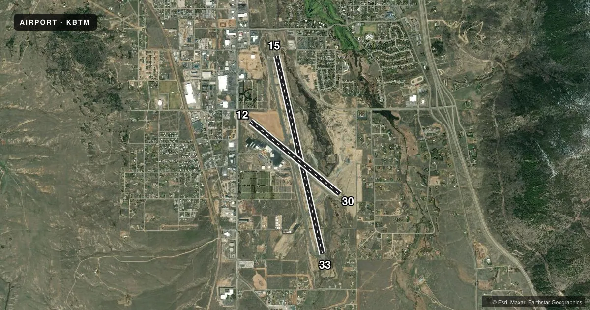
Runways & pattern
Full pagePattern entry · RWY 12
LEFT TRAFFIC| Runway | Heading (°M) | Length | Surface | Traffic |
|---|---|---|---|---|
| 15/33 | 155° / 335° | 9,000 ft | ASPH | 15 R |
| 12/30Favored | 117° / 297° | 5,100 ft | ASPH | Standard L |
Runway end performance
| End | TORA | TODA | ASDA | LDA | VGSI | Approach lights | Obstruction |
|---|---|---|---|---|---|---|---|
| 15 | 9,000' | 9,000' | 9,000' | 9,000' | PAPI 4-box left(3.5°) | MALSR | — |
| 33 | 9,000' | 9,000' | 9,000' | 9,000' | VASI 2-box left(3°) | — | 65', tower, 2986' from thr, 248' R of cntrln, slope 42 |
| 12 | 5,100' | 5,100' | 5,100' | 5,100' | PAPI 2-box left(4°) | — | 16', road, 560' from thr, 275' R of cntrln, slope 22 |
| 30 | 5,100' | 5,100' | 5,100' | 5,100' | PAPI 2-box left(4°) | — | 36', bldg, 1251' from thr, 100' R of cntrln, slope 29 |
Declared distances in feet. TORA = takeoff run available, TODA = takeoff distance, ASDA = accelerate-stop, LDA = landing distance.
Airport sketch
Runways drawn to scale from FAA survey coordinates, rendered over satellite imagery. Not for navigation.
Approaches & charts
ILS · 1
Services on the field
Fuel grades, oxygen, maintenance, ramp storage and lighting — as declared to the FAA by the airport operator.
Fuel & services
- Fuel
- 100100LLA
- Oxygen (bottled)
- HIGH/LOW
- Oxygen (bulk)
- HIGH/LOW
- Airframe repair
- Major
- Power plant repair
- Major
- Other services
- AFRT,CHTR,INSTR,RNTL,SALES
Ramp & ground
- Transient storage
- Tie-down
- Hangar
- Landing fee
- Yes
- Customs
- Not available
- Lighting schedule
- SEE RMK
- Beacon schedule
- SS-SR
- Beacon
- White / Green (civil land)(WG)
- Wind indicator
- Lighted
- Segmented circle
- Yes
Fuel & FBOs
Cheapest 100LL and Jet A on the field and nearby. Always confirm with the FBO before taxi.
Airport notes
Surface conditions, obstructions, local procedures, lighting outages and other notes published with each FAA cycle.
General notes
- DEER IN VICINITY OF AIRPORT.
- SNOW REMOVAL OPS IN PROGRES DURING PERIODS OF SNOW.
- COLD TEMPERATURE AIRPORT. ALTITUDE CORRECTION REQUIRED AT OR BELOW -24C.
- FOR CD IF UNA TO CTC ON FSS FREQ, CTC SALT LAKE ARTCC AT 801-320-2568.
- TWY D RSTD TO ACFT WITH WINGSPAN LESS THAN 100 FT WO PPR, CALL APMGR 406-494-3771.
Lighting notes
- ACTVT MALSR RWY 15; REIL RWY 12 & 30; PAPI RWY 12 & 30; VASI RWY 33; MIRL RWY 15/33 & 12/30 - CTAF. PAPI RWY 15 OPR CONSLY.
Runway surface & condition
- 12/30PCR VALUE: 210/F/A/X/T
- 15/33PCR VALUE: 510/F/A/X/T
Approach & departure obstructions
- 12PAPI UNUSBL BYD 5 DEG RIGHT OF RCL.
- 30PAPI RSTRD TO 2.1 NM FM RWY 30 THLD DUE TO HIGH TERRAIN. PAPI UNUSBL BYD 2 DEG RIGHT OF RCL.
- 33DO NOT USE VASI BYD 1.5 MI DUE TO HIGH TERRAIN.
Other notes
- PPR FOR UNSKED ACR OPNS WITH MORE THAN 30 PSGR SEATS CALL AMGR 406-494-3771.
- FEE FOR ALL COML ACFT & ACFT OVER 9000 LBS.
- 12/30SURFACE CONDITIONS UNMONITORED BETWEEN MIDNIGHT AND 5 A.M.
VFR map & nearby airports
VFR sectional. Tap any ICAO chip to open that airport.
Key facts · KBTM
Answer card- ICAO
- KBTM
- Name
- BERT MOONEY
- Location
- BUTTE, MONTANA
- Elevation
- 5,550.5 ft MSL
- Traffic pattern altitude
- 6,550.5 ft MSL (1,000 AGL)
- Control tower
- Non-towered (use CTAF)
- Total runways
- 2
- Longest runway
- 15/33 · 9,000 ft
- Published ILS approaches
- 1
- Published frequencies
- 2
- Magnetic variation
- 12°
- Current flight rules
- MVFR
- Current wind
- 130° at 5 kt
- Favored runway now
- RWY 12
Bert Mooney Airport sits in Butte, Montana at 5,550.5 ft MSL. It has two asphalt runways. The longest is runway 15/33 at 9,000 ft. There is no control tower, so plan on CTAF 123.0 for local traffic and UNICOM 123.0 for field services. The airport has one ILS approach to runway 15. Pattern altitude is not published in the facts. Use the standard 1,000 ft AGL for light piston traffic unless the current FAA Chart Supplement says otherwise.
Butte Aviation is on the field. It carries 100LL, Jet A and Jet A Prist. If you are bringing a larger aircraft, note the published restriction on taxiway D for wingspans under 100 ft unless you have prior permission. The field also has cold weather notes. Altitude correction is required at or below minus 24 C. Snow removal can be active during snowy periods. Deer are also reported in the airport area.
Terrain matters here. Runway 33 has a VASI that should not be used beyond 1.5 NM because of high terrain. Runway 30 has a PAPI that is limited to 2.1 NM from the threshold. The PAPI on runway 12 is also restricted to the right of centerline. Check the current FAA Chart Supplement before departure for any operational changes, especially if you are flying a commercial aircraft or anything over 9,000 lb.