METAR & TAF S69
S69 does not publish a METAR.
Showing the nearest reporting station: KHLN (HELENA RGNL) · 34.5 NM away. Conditions at S69 may differ.
METAR · KHLN
Observed 11:53Z
KHLN 271153Z 00000KT 7SM CLR 19/07 A3006 RMK AO2 SLP153 T01940067 10250 20178 52009 $
- Wind
- 000° @ 0 kt
- Visibility
- 7 SM
- Temp / Dew
- 19°C / 7°C
- Altimeter
- 30.06 inHg
- Clouds
- CLR
- Density alt
- 6,014 ft
- Ceiling
- Unlimited
- Rules
- VFR
Airport info & contacts
Manager on record, flight service, ARTCC, attendance schedule and pattern altitude — published by the FAA and refreshed every 28 days.
Location
- From city
- 2 NM E
- VFR sectional
- GREAT FALLS
- ARTCC
- ZLC · SALT LAKE CITY
- NOTAM facility
- GTF (NOTAM-D)
Airport manager
- Name
- TIM CONWAY
- Phone
- 406-444-2506
- Address
- PO BOX 200507, HELENA MT 59620-0507
Flight service · Hours
- FSS GTF
- GREAT FALLS1-800-WX-BRIEF
- Attendance
- Unattended
Frequencies
Tap any row to copy the frequency to your clipboard.
Runways & pattern
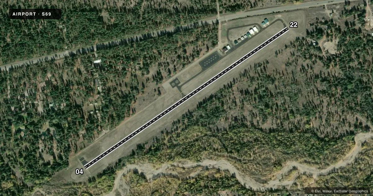
Full pagePattern entry · RWY 04
LEFT TRAFFICRunway end performance
| End | TORA | TODA | ASDA | LDA | VGSI | Approach lights | Obstruction |
|---|---|---|---|---|---|---|---|
| 04 | — | — | — | — | PAPI 2-box left(4°) | — | 101', trees, 1060' from thr, 150' R of cntrln, slope 8 |
| 22 | — | — | — | — | — | — | 90', trees, 1221' from thr, 330' R of cntrln, slope 11 |
Declared distances in feet. TORA = takeoff run available, TODA = takeoff distance, ASDA = accelerate-stop, LDA = landing distance.
Airport sketch
Runways drawn to scale from FAA survey coordinates, rendered over satellite imagery. Not for navigation.
Approaches & charts
Services on the field
Fuel grades, oxygen, maintenance, ramp storage and lighting — as declared to the FAA by the airport operator.
Fuel & services
- Fuel
- Not available
Ramp & ground
- Transient storage
- Tie-down
- Landing fee
- No fee published
- Customs
- Not available
- Lighting schedule
- SEE RMK
- Beacon schedule
- SS-SR
- Beacon
- White / Green (civil land)(WG)
- Wind indicator
- Lighted
- Segmented circle
- Yes
Fuel & FBOs
Cheapest 100LL and Jet A on the field and nearby. Always confirm with the FBO before taxi.
Airport notes
Surface conditions, obstructions, local procedures, lighting outages and other notes published with each FAA cycle.
General notes
- SFC COND UNMON 1600-0900. IREG SN REMOVAL. SEE HTTPS://WEATHERCAMS.FAA.GOV/
- HEL OPS INVOF ARPT DURG SUMMER.
- 9 FT PERIMETER FENCE.
- FOR CD CTC HELENA APCH AT 406-449-5756/5761, WHEN APCH CLSD CTC SALT LAKE ARTCC AT 801-320-2568.
- WX ADVISORY AVAIL ON CTAF - 4 CLICKS.
Lighting notes
- ACTVT PAPI RWY 04; MIRL RWY 04/22 - CTAF.
Runway surface & condition
- 04/22TREES IN TRSN SFC BOTH SIDES FULL LEN.
Other notes
- FURN OWN ROPES.
VFR map & nearby airports
VFR sectional. Tap any ICAO chip to open that airport.
Key facts · S69
Answer card- ICAO
- S69
- Name
- LINCOLN
- Location
- LINCOLN, MONTANA
- Elevation
- 4,602.8 ft MSL
- Traffic pattern altitude
- 5,602.8 ft MSL (1,000 AGL)
- Control tower
- Non-towered (use CTAF)
- Total runways
- 1
- Longest runway
- 04/22 · 4,240 ft
- Published ILS approaches
- 0
- Published frequencies
- 3
- Magnetic variation
- 12°
- Current flight rules
- VFR
- Current wind
- 000° at 0 kt
- Favored runway now
- –
Lincoln Airport sits in Lincoln, Montana. The field elevation is 4,602.8 ft MSL. It has one runway. Runway 04/22 is 4,240 ft long. There is no control tower. The pattern altitude is not published, so use the standard 1,000 ft AGL for light piston traffic unless the current Chart Supplement says otherwise.
No ILS approaches are published here. Approach and departure service is handled by Helena on 119.5 and 229.4. CTAF is 122.9. For clearance delivery, the published remarks direct pilots to Helena Approach by phone. If approach is closed, contact Salt Lake ARTCC by phone. That matters if you are filing IFR into the field.
There are no on-field FBOs listed in the facts. Plan on bringing your own ropes. The airport has a 9-foot perimeter fence. Surface conditions are unmonitored from 1600 to 0900. Snow removal is irregular, so check current field conditions before you go. The CTAF can trigger the weather advisory. Runway 04 has PAPI. Medium intensity runway lights on 04 and 22 are also activated on CTAF. Trees are on the transition surface on both sides along the full length of the runway. Summer helicopter activity is also published in the area, so expect mixed traffic and keep your scan tight.