METAR & TAF 23S
23S does not publish a METAR.
Showing the nearest reporting station: KMSO (MISSOULA MONTANA) · 30.8 NM away. Conditions at 23S may differ.
METAR · KMSO
Observed 11:53Z
KMSO 271153Z 00000KT 7SM FU CLR 13/07 A3009 RMK AO2 SLP167 T01280067 10239 20122 53009 $
- Wind
- 000° @ 0 kt
- Visibility
- 7 SM
- Temp / Dew
- 13°C / 7°C
- Altimeter
- 30.09 inHg
- Clouds
- CLR
- Density alt
- 4,827 ft
- Ceiling
- Unlimited
- Rules
- VFR
Airport info & contacts
Manager on record, flight service, ARTCC, attendance schedule and pattern altitude — published by the FAA and refreshed every 28 days.
Location
- From city
- 2 NM E
- VFR sectional
- GREAT FALLS
- ARTCC
- ZLC · SALT LAKE CITY
- NOTAM facility
- GTF (NOTAM-D)
Airport manager
- Name
- TIM CONWAY
- Phone
- 406-444-2506
- Address
- PO BOX 200507, HELENA MT 59620-0507
Flight service · Hours
- FSS GTF
- GREAT FALLS1-800-WX-BRIEF
- Attendance
- Unattended
Frequencies
Tap any row to copy the frequency to your clipboard.
Runways & pattern
Full pagePattern entry · RWY 16
LEFT TRAFFICRunway end performance
| End | TORA | TODA | ASDA | LDA | VGSI | Approach lights | Obstruction |
|---|---|---|---|---|---|---|---|
| 16 | — | — | — | — | — | — | 50', trees, 350' from thr, slope 7 |
Declared distances in feet. TORA = takeoff run available, TODA = takeoff distance, ASDA = accelerate-stop, LDA = landing distance.
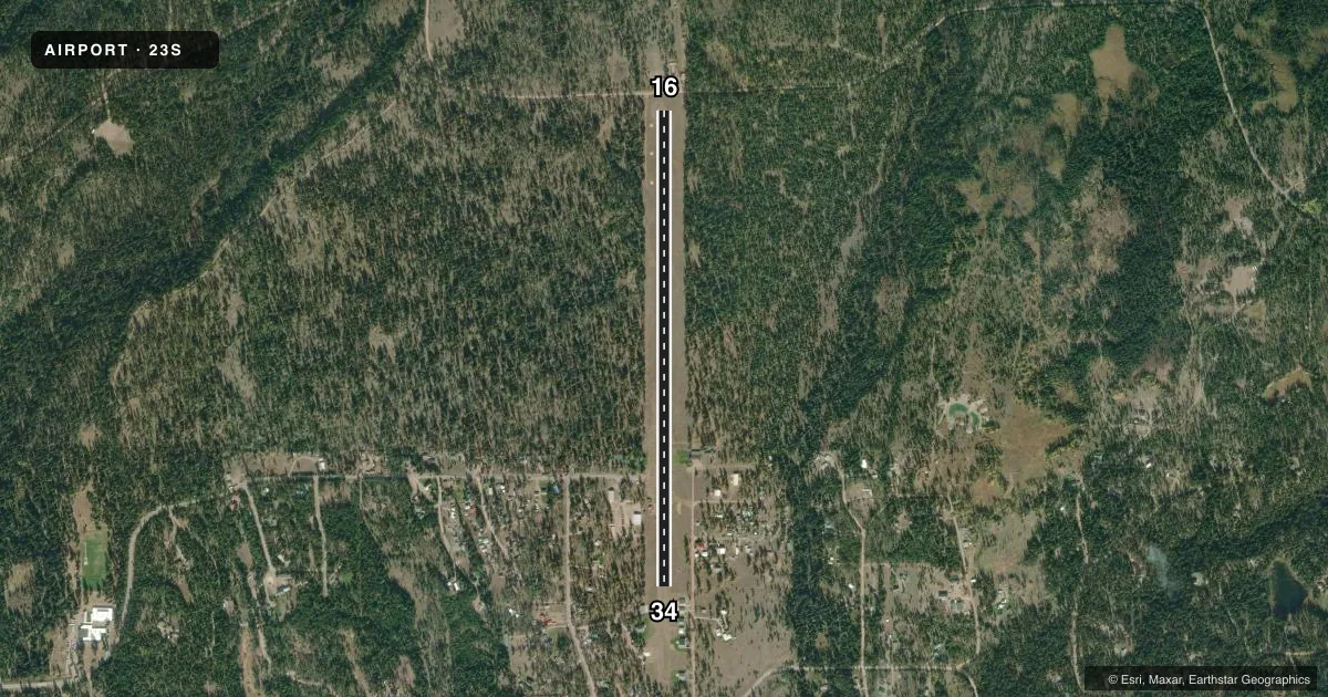
Airport sketch
Runways drawn to scale from FAA survey coordinates, rendered over satellite imagery. Not for navigation.
Approaches & charts
Services on the field
Fuel grades, oxygen, maintenance, ramp storage and lighting — as declared to the FAA by the airport operator.
Fuel & services
- Fuel
- Not available
- Oxygen (bottled)
- Not available
- Oxygen (bulk)
- Not available
- Airframe repair
- Not available
- Power plant repair
- Not available
Ramp & ground
- Transient storage
- Tie-down
- Landing fee
- No fee published
- Lighting schedule
- SEE RMK
- Beacon schedule
- SS-SR
- Beacon
- White(W)
- Wind indicator
- Yes
- Segmented circle
- Yes
Fuel & FBOs
Cheapest 100LL and Jet A on the field and nearby. Always confirm with the FBO before taxi.
Airport notes
Surface conditions, obstructions, local procedures, lighting outages and other notes published with each FAA cycle.
General notes
- TKOFS TO N NOT RECOMMENDED DUE TO RISING TRRN.
- TREES IN TRANSITIONAL SFC FULL RWY LEN BOTH SIDES.
- BIRDS & WILDLIFE ON & INVOF ARPT.
- SNOW REMOVAL INTMT, CALL AMGR FOR CURRENT CONDS 406-444-2506.
- RWY 34 HAS 1150 FT OVRN AVBL FOR TKOF AND LDG.
- CREW CAR AVBL.
- FOR CD CTC SPOKANE APCH AT 509-742-2522, WHEN APCH CLSD CTC SALT LAKE ARTCC AT 801-320-2568
- RWY 16 DTHR 311 FT FM RWY END FOR 20:1 APCH SLP MKD WITH DBL W CONES.
Lighting notes
- RWY 34 SOLAR LGTS FIRST 2/3 OF RWY - SUMMER MONTHS ONLY
Approach & departure obstructions
- 16RWY 16 MKD FULL LEN WITH W CONES & REFLECTIVE TAPE - SUMMER MONTHS ONLY
- 34RWY 34 MKD FULL LEN WITH W CONES & REFLECTIVE TAPE - SUMMER MONTHS ONLY.
VFR map & nearby airports
VFR sectional. Tap any ICAO chip to open that airport.
Key facts · 23S
Answer card- ICAO
- 23S
- Name
- SEELEY LAKE
- Location
- SEELEY LAKE, MONTANA
- Elevation
- 4,256 ft MSL
- Traffic pattern altitude
- 5,256 ft MSL (1,000 AGL)
- Control tower
- Non-towered (use CTAF)
- Total runways
- 1
- Longest runway
- 16/34 · 4,575 ft
- Published ILS approaches
- 0
- Published frequencies
- 1
- Magnetic variation
- 18°
- Current flight rules
- VFR
- Current wind
- 000° at 0 kt
- Favored runway now
- –
Seeley Lake Airport sits in Seeley Lake, Montana. Field elevation is 4,256 ft MSL. The airport has one runway. Runway 16/34 is 4,575 ft long and turf. No tower is published here. CTAF is 122.9.
No ILS approaches are published. Pattern altitude is not published, so use the standard 1,000 ft AGL for light piston operations unless the current FAA Chart Supplement says otherwise. That puts the traffic pattern at 5,256 ft MSL based on the field elevation. The field sits in mountain country. Takeoffs to the north are not recommended because of rising terrain. Trees are also in the transitional surface along the full runway length on both sides.
Published remarks matter here. Runway 16 has a displaced threshold 311 ft from the end. Runway 34 has 1,150 ft of overrun available for takeoff and landing. Summer markings and solar lights are published for parts of the runway. Snow removal is intermittent. Call the airport manager for current conditions before you go. Birds and wildlife are also reported on and near the airport. Crew car service is available. No on-field FBOs are listed, so verify services with the airport operator before arrival.