METAR & TAF 3U7
3U7 does not publish a METAR.
Showing the nearest reporting station: KMSO (MISSOULA MONTANA) · 60.2 NM away. Conditions at 3U7 may differ.
METAR · KMSO
Observed 00:53Z
KMSO 240053Z 01010KT 10SM FEW110 25/06 A3010 RMK AO2 SLP178 T02500061 $
- Wind
- 010° @ 10 kt
- Visibility
- 10 SM
- Temp / Dew
- 25°C / 6°C
- Altimeter
- 30.10 inHg
- Clouds
- FEW
- Density alt
- 7,715 ft
- Ceiling
- Unlimited
- Rules
- VFR
Airport info & contacts
Manager on record, flight service, ARTCC, attendance schedule and pattern altitude — published by the FAA and refreshed every 28 days.
Location
- From city
- 19 NM W
- VFR sectional
- GREAT FALLS
- ARTCC
- ZLC · SALT LAKE CITY
- NOTAM facility
- GTF (NOTAM-D)
Airport manager
- Name
- BJORN TROBERG
- Phone
- (406) 495-3832
- Address
- HELENA & LEWIS & CLARK NAT FORESTS, 2880 SKYWAY DRIVE, HELENA MT 59602
Flight service · Hours
- FSS GTF
- GREAT FALLS1-800-WX-BRIEF
- Attendance
- Unattended
Frequencies
Tap any row to copy the frequency to your clipboard.
Runways & pattern
Full pagePattern entry · RWY 30
LEFT TRAFFICRunway end performance
| End | TORA | TODA | ASDA | LDA | VGSI | Approach lights | Obstruction |
|---|---|---|---|---|---|---|---|
| 12 | — | — | — | — | — | — | 39', trees, 372' from thr, 0' R of cntrln, slope 4 |
| 30 | — | — | — | — | — | — | 41', trees, 461' from thr, 0' R of cntrln, slope 6 |
Declared distances in feet. TORA = takeoff run available, TODA = takeoff distance, ASDA = accelerate-stop, LDA = landing distance.
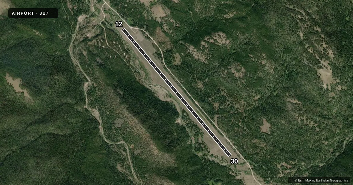
Airport sketch
Runways drawn to scale from FAA survey coordinates, rendered over satellite imagery. Not for navigation.
Approaches & charts
Services on the field
Fuel grades, oxygen, maintenance, ramp storage and lighting — as declared to the FAA by the airport operator.
Fuel & services
- Fuel
- Not available
Ramp & ground
- Transient storage
- Tie-down
- Landing fee
- No fee published
- Customs
- Not available
- Wind indicator
- Yes
- Segmented circle
- Yes
Fuel & FBOs
Cheapest 100LL and Jet A on the field and nearby. Always confirm with the FBO before taxi.
Airport notes
Surface conditions, obstructions, local procedures, lighting outages and other notes published with each FAA cycle.
General notes
- SNOW REMOVAL NA.
- FONE NA; CABIN 1 MI NW.
- SVCS NA.
- FOR CD CTC SALT LAKE ARTCC AT 801-320-2568.
- MTS PARL E & W; IN TRSN SFC.
Runway surface & condition
- 12/30PSBL MOD-SVR CROSSWIND & TURB.
Approach & departure obstructions
- 12RISES UPHILL 120 FT; RISING TRRN BYD.
- 30RCMDD DEP COND PMTG.
- 12+58 FT TREES ON CNTRLN.
- 30+250 FT TREES ON CNTRLN.
- 1233:1 TO THR. +65 FT TREES 0-150 FT R 2150 FT FM RWY END.
Other notes
- WI LEWIS & CLARK NATIONAL FOREST.
- 3 WDI; BOTH ENDS & MIDPT.
- 12/30LRG CRACKS & WEEDS FULL LEN.
VFR map & nearby airports
VFR sectional. Tap any ICAO chip to open that airport.
Key facts · 3U7
Answer card- ICAO
- 3U7
- Name
- BENCHMARK
- Location
- AUGUSTA, MONTANA
- Elevation
- 5,434 ft MSL
- Traffic pattern altitude
- 6,434 ft MSL (1,000 AGL)
- Control tower
- Non-towered (use CTAF)
- Total runways
- 1
- Longest runway
- 12/30 · 6,000 ft
- Published ILS approaches
- 0
- Published frequencies
- 1
- Magnetic variation
- 18°
- Current flight rules
- VFR
- Current wind
- 010° at 10 kt
- Favored runway now
- RWY 30
Benchmark Airport sits near Augusta, Montana. The field elevation is 5,434 ft MSL. It has one runway, 12/30, at 6,000 ft. There is no control tower. CTAF is 122.9. No ILS approaches are published here.
Pattern altitude is not published. Use the standard 1,000 ft AGL pattern unless the current Chart Supplement says otherwise. That puts the light piston pattern at about 6,434 ft MSL. The airport sits in Lewis and Clark National Forest. Mountains lie parallel east and west. The remarks also call out rising terrain beyond runway 12. Runway 12 has a 120 ft uphill rise. The runway also has large cracks and weeds along its full length. Snow removal is not available.
There are no on-field FBOs listed. Plan on self-briefing the airport operator or the FBO directly by phone if you need local services. The published remarks also note trees near both runway ends. There are 58 ft trees on the runway centerline at runway 12. There are 250 ft trees on the runway centerline at runway 30. Expect crosswind and turbulence issues in the area. Clearance delivery is handled through Salt Lake ARTCC at 801-320-2568. For a first visit, treat this as a high-elevation mountain field with terrain, wind and runway condition concerns all in play.