METAR & TAF KCII
KCII does not publish a METAR.
Showing the nearest reporting station: KGTF (GREAT FALLS INTL) · 38.4 NM away. Conditions at KCII may differ.
METAR · KGTF
Observed 19:53Z
KGTF 261953Z 24004KT 6SM HZ CLR 31/06 A2999 RMK AO2 SLP115 T03110056 $
- Wind
- 240° @ 4 kt
- Visibility
- 6 SM
- Temp / Dew
- 31°C / 6°C
- Altimeter
- 29.99 inHg
- Clouds
- CLR
- Density alt
- 6,727 ft
- Ceiling
- Unlimited
- Rules
- VFR
Airport info & contacts
Manager on record, flight service, ARTCC, attendance schedule and pattern altitude — published by the FAA and refreshed every 28 days.
Location
- From city
- 1 NM NE
- VFR sectional
- GREAT FALLS
- ARTCC
- ZLC · SALT LAKE CITY
- NOTAM facility
- GTF (NOTAM-D)
Airport manager
- Name
- CHRISSY HODGSKISS
- Phone
- 303-881-8809
- Address
- PO BOX 1445, CHOTEAU MT 59422
Flight service · Hours
- FSS GTF
- GREAT FALLS1-800-WX-BRIEF
- Attendance
- MON-FRI · 0800-1700
Frequencies
Tap any row to copy the frequency to your clipboard.
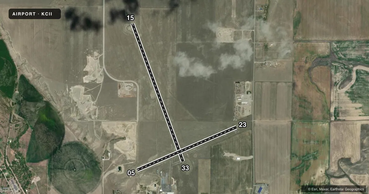
Runways & pattern
Full pagePattern entry · RWY 23
LEFT TRAFFIC| Runway | Heading (°M) | Length | Surface | Traffic |
|---|---|---|---|---|
| 15/33 | 148° / 328° | 5,000 ft | ASPH | Standard L |
| 05/23Favored | 55° / 235° | 3,699 ft | ASPH | Standard L |
Runway end performance
| End | TORA | TODA | ASDA | LDA | VGSI | Approach lights | Obstruction |
|---|---|---|---|---|---|---|---|
| 15 | — | — | — | — | PAPI 2-box left(3°) | — | — |
| 33 | — | — | — | — | PAPI 2-box left(3°) | — | — |
| 05 | — | — | — | — | PAPI 2-box left(3°) | — | — |
| 23 | — | — | — | — | PAPI 2-box left(3°) | — | 20', road, 590' from thr, 0' R of cntrln, slope 19 |
Declared distances in feet. TORA = takeoff run available, TODA = takeoff distance, ASDA = accelerate-stop, LDA = landing distance.
Airport sketch
Runways drawn to scale from FAA survey coordinates, rendered over satellite imagery. Not for navigation.
Approaches & charts
Services on the field
Fuel grades, oxygen, maintenance, ramp storage and lighting — as declared to the FAA by the airport operator.
Fuel & services
- Fuel
- 100LLA
- Other services
- AGRI
Ramp & ground
- Transient storage
- Tie-down
- Hangar
- Landing fee
- No fee published
- Customs
- Not available
- Lighting schedule
- SEE RMK
- Beacon schedule
- SS-SR
- Beacon
- White / Green (civil land)(WG)
- Wind indicator
- Lighted
- Segmented circle
- Yes
Fuel & FBOs
Cheapest 100LL and Jet A on the field and nearby. Always confirm with the FBO before taxi.
Airport notes
Surface conditions, obstructions, local procedures, lighting outages and other notes published with each FAA cycle.
General notes
- 100LL 24/7 SELF SVC. JET A+ FULL SVC CALL OUT ONLY AFT HRS.
- FOR CD CTC SALT LAKE ARTCC AT 801-320-2568.
Lighting notes
- ACTVT PAPI RWY 05, 23,15 & 33; MIRL RWY 05/23 & 15/33 - CTAF.
VFR map & nearby airports
VFR sectional. Tap any ICAO chip to open that airport.
Key facts · KCII
Answer card- ICAO
- KCII
- Name
- CHOTEAU
- Location
- CHOTEAU, MONTANA
- Elevation
- 3,946.6 ft MSL
- Traffic pattern altitude
- 4,946.6 ft MSL (1,000 AGL)
- Control tower
- Non-towered (use CTAF)
- Total runways
- 2
- Longest runway
- 15/33 · 5,000 ft
- Published ILS approaches
- 0
- Published frequencies
- 2
- Magnetic variation
- 12°
- Current flight rules
- VFR
- Current wind
- 240° at 4 kt
- Favored runway now
- RWY 23
Choteau Airport sits in Choteau, Montana. Field elevation is 3,946.6 ft MSL. It has two asphalt runways. The longest is runway 15/33 at 5,000 ft. Runway 05/23 is 3,699 ft. There is no control tower, so expect non-towered traffic flow on CTAF 122.8. UNICOM is also 122.8.
No ILS approaches are published here. Pattern altitude is not published in the facts, so use the standard 1,000 ft AGL for light piston operations unless the current Chart Supplement says otherwise. That puts the normal traffic pattern near 4,946.6 ft MSL. Runway lighting is pilot-controlled on both runways. PAPI is listed for 05, 23, 15 and 33. That helps at night or in marginal light.
Choteau Airport has one on-field FBO. Choteau Airport carries 100LL and Jet A Prist. 100LL is available self-serve 24 hours a day. Jet A full service is available by call out after hours. For clearance delivery, contact Salt Lake ARTCC at 801-320-2568. With the field sitting near 4,000 ft MSL, plan for mountain-airport performance and density altitude. Check the current Chart Supplement for any local remarks before departure.