METAR & TAF KGTF
Current METAR
Observed 01:53Z
KGTF 260153Z 20008KT 10SM CLR 34/11 A2981 RMK AO2 SLP051 T03390106 $
- Wind
- 200° @ 8 kt
- Visibility
- 10 SM
- Temp / Dew
- 34°C / 11°C
- Altimeter
- 29.81 inHg
- Clouds
- CLR
- Density alt
- 6,980 ft
- Ceiling
- Unlimited
- Rules
- VFR
Airport info & contacts
Manager on record, flight service, ARTCC, attendance schedule and pattern altitude — published by the FAA and refreshed every 28 days.
Location
- From city
- 3 NM SW
- VFR sectional
- GREAT FALLS
- ARTCC
- ZLC · SALT LAKE CITY
- NOTAM facility
- GTF (NOTAM-D)
Airport manager
- Name
- JOHN FAULKNER
- Phone
- 406-727-3404
- Address
- 2800 TERMINAL DRIVE, GREAT FALLS MT 59404-5599
Flight service · Hours
- FSS GTF
- GREAT FALLS1-800-WX-BRIEF
- Attendance
- ALL
Frequencies
Tap any row to copy the frequency to your clipboard.
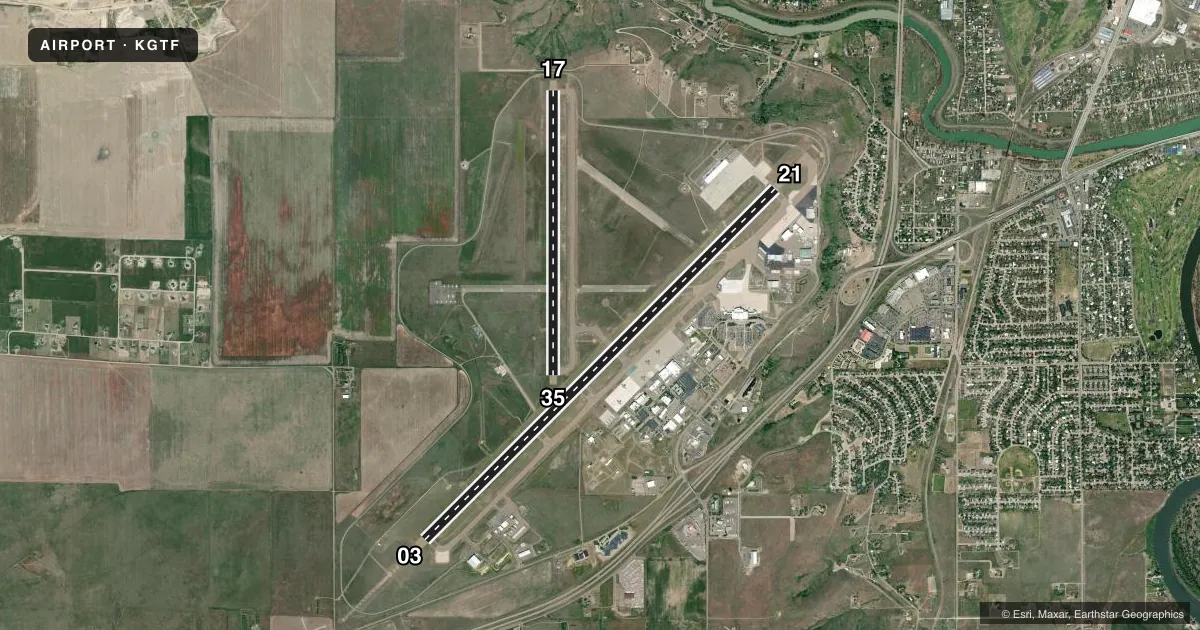
Runways & pattern
Full pagePattern entry · RWY 17
LEFT TRAFFIC| Runway | Heading (°M) | Length | Surface | Traffic |
|---|---|---|---|---|
| 03/21 | 32° / 212° | 10,502 ft | ASPH | Standard L |
| 17/35Favored | 167° / 347° | 6,030 ft | ASPH | Standard L |
Runway end performance
| End | TORA | TODA | ASDA | LDA | VGSI | Approach lights | Obstruction |
|---|---|---|---|---|---|---|---|
| 03 | 10,502' | 10,502' | 10,502' | 10,502' | PAPI 4-box left(3°) | ALSF2 | 25', road, 1300' from thr, 645' R of cntrln, slope 43 |
| 21 | 10,502' | 10,502' | 10,502' | 10,502' | PAPI 4-box right(3°) | — | — |
| 17 | 6,030' | 6,030' | 6,030' | 5,800' | PAPI 4-box left(3°) | — | 10', road, 345' from thr, 266' R of cntrln, slope 14 |
| 35 | 5,400' | 5,400' | 5,400' | 5,400' | PAPI 4-box left(3°) | — | — |
Declared distances in feet. TORA = takeoff run available, TODA = takeoff distance, ASDA = accelerate-stop, LDA = landing distance.
Airport sketch
Runways drawn to scale from FAA survey coordinates, rendered over satellite imagery. Not for navigation.
Approaches & charts
ILS · 1
Services on the field
Fuel grades, oxygen, maintenance, ramp storage and lighting — as declared to the FAA by the airport operator.
Fuel & services
- Fuel
- 100LLA
- Oxygen (bottled)
- HIGH/LOW
- Oxygen (bulk)
- HIGH/LOW
- Airframe repair
- Major
- Power plant repair
- Major
- Other services
- AFRT,AGRI,AVNCS,CARGO,CHTR,INSTR,RNTL,SALES
Ramp & ground
- Transient storage
- Tie-down
- Hangar
- Landing fee
- No fee published
- Customs
- Available
- Lighting schedule
- SEE RMK
- Beacon schedule
- SS-SR
- Beacon
- White / Green (civil land)(WG)
- Wind indicator
- Yes
- Segmented circle
- Yes
Fuel & FBOs
Cheapest 100LL and Jet A on the field and nearby. Always confirm with the FBO before taxi.
Airport notes
Surface conditions, obstructions, local procedures, lighting outages and other notes published with each FAA cycle.
General notes
- MILITARY: ANG: OPR 1400-2330Z++ MON-THU, LTD FRI, CLOSED SAT-SUN AND HOL. BASE OPS DSN 791-0192, C406-791-0192. NO TRAN SVC SAT, SUN, HOL OR AFTER 2300Z++ MON-FRI. ACFT RQR ASSISTANCE CTC 288.9. RCR INFO AVBL FR BASE OPS.
- MILITARY: ANG: LTD TRAN SVC ONLY AVBL FOR ACFT PARTICIPATING IN ANG OPS WITH PRIOR COORDINATION (PPR).
- BIRDS ON AND INVOF ARPT.
- MILITARY: ANG: USAF BASH - EXP INCREASED MIGRATORY WATERFOWL ACT (PHASE II) MAR-MAY AND SEP-DEC, SR-.5 TO SS+.5.
- MILITARY: ANG: NSTD WHITE EQPT TOOL BOX LCTN PAINTED ON RAMP.
- MILITARY: ANG: FUEL: A++ AVBL AT ANG.
- TWY C UNRSTD WT AND AVBL FOR TAXIING ACFT.
Lighting notes
- REIL RWY 21 OPR CONSLY WHEN RWY LGTS ARE ON. RWY LGTS CTLD BY TWR.
Runway surface & condition
- 03/21FOR DC-10-40 AND B747.
- 03/21PCR VALUE: 5290/F/B/X/T
- 17/35PCR VALUE: 300/F/B/X/U
Approach & departure obstructions
- 03PAPI UNUSBL BYD 9 DEGS RIGHT OF CNTRLN.
Other notes
- INDEX LEVEL C ARFF CAPABILITY IS AVBL AT ALL TIMES.
VFR map & nearby airports
VFR sectional. Tap any ICAO chip to open that airport.
Key facts · KGTF
Answer card- ICAO
- KGTF
- Name
- GREAT FALLS INTL
- Location
- GREAT FALLS, MONTANA
- Elevation
- 3,680 ft MSL
- Traffic pattern altitude
- 4,680 ft MSL (1,000 AGL)
- Control tower
- Towered · 24
- Total runways
- 2
- Longest runway
- 03/21 · 10,502 ft
- Published ILS approaches
- 1
- Published frequencies
- 17
- Magnetic variation
- 13°
- Current flight rules
- VFR
- Current wind
- 200° at 8 kt
- Favored runway now
- RWY 17
Great Falls Intl is in Great Falls, Montana. The field elevation is 3,680 ft MSL. It has two asphalt runways. The longest is 10,502 ft on runway 03/21. The airport is towered 24 hours. One ILS approach is published for runway 03.
Pattern altitude is not published in the facts. Use the current FAA Chart Supplement for the official pattern. Plan on the standard 1,000 ft AGL for light piston traffic if nothing else is published. That puts the common pattern reference at 4,680 ft MSL based on the field elevation. Check the current Chart Supplement before you go.
Great Falls Jet Center is on the field. It carries 100LL and Jet A Prist. Holman Aviation is also on the field. It carries 100LL, Jet A and Jet A Prist. For a first-time arrival, pay attention to the high field elevation and the published military activity on the field. Runway 03/21 has a published pavement rating. Runway 03 has a note that the PAPI is unusable beyond 9 degrees right of centerline. Runway 21 end identifier lights stay on whenever runway lights are on. The airport also has 24-hour ARFF coverage. If you are planning around the Air National Guard activity, check current field status and coordination needs with the airport operator or base operations before departure.