METAR & TAF S01
S01 does not publish a METAR.
Showing the nearest reporting station: KSBX (SHELBY) · 22.8 NM away. Conditions at S01 may differ.
METAR · KSBX
Observed 17:35Z
KSBX 261735Z AUTO 23004KT 10SM CLR 25/07 A3003 RMK AO2
- Wind
- 230° @ 4 kt
- Visibility
- 10 SM
- Temp / Dew
- 25°C / 7°C
- Altimeter
- 30.03 inHg
- Clouds
- CLR
- Density alt
- 5,464 ft
- Ceiling
- Unlimited
- Rules
- VFR
Airport info & contacts
Manager on record, flight service, ARTCC, attendance schedule and pattern altitude — published by the FAA and refreshed every 28 days.
Location
- From city
- 1 NM W
- VFR sectional
- GREAT FALLS
- ARTCC
- ZLC · SALT LAKE CITY
- NOTAM facility
- GTF (NOTAM-D)
Airport manager
- Name
- HEATH ELINGS
- Phone
- (406) 450-1620
- Address
- 111 GARLAND STREET, KALISPELL MT 59901
Flight service · Hours
- FSS GTF
- GREAT FALLS1-800-WX-BRIEF
- Attendance
- UNATTND
Frequencies
Tap any row to copy the frequency to your clipboard.
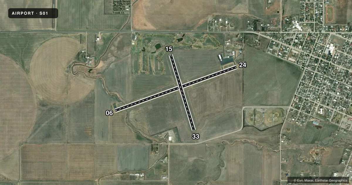
Runways & pattern
Full pagePattern entry · RWY 24
LEFT TRAFFIC| Runway | Heading (°M) | Length | Surface | Traffic |
|---|---|---|---|---|
| 06/24Favored | 58° / 238° | 4,602 ft | ASPH | Standard L |
| 15/33 | 151° / 331° | 2,800 ft | TURF | Standard L |
Runway end performance
| End | TORA | TODA | ASDA | LDA | VGSI | Approach lights | Obstruction |
|---|---|---|---|---|---|---|---|
| 06 | — | — | — | — | PAPI 2-box left(3°) | — | 54', pline, 1667' from thr, 0' R of cntrln, slope 27 |
| 24 | — | — | — | — | PAPI 2-box left(3°) | — | — |
Declared distances in feet. TORA = takeoff run available, TODA = takeoff distance, ASDA = accelerate-stop, LDA = landing distance.
Airport sketch
Runways drawn to scale from FAA survey coordinates, rendered over satellite imagery. Not for navigation.
Approaches & charts
Services on the field
Fuel grades, oxygen, maintenance, ramp storage and lighting — as declared to the FAA by the airport operator.
Fuel & services
- Fuel
- 100LL
- Other services
- AGRI
Ramp & ground
- Transient storage
- Tie-down
- Hangar
- Landing fee
- No fee published
- Customs
- Not available
- Lighting schedule
- SEE RMK
- Beacon schedule
- SS-SR
- Beacon
- White / Green (civil land)(WG)
- Wind indicator
- Lighted
- Segmented circle
- Yes
Fuel & FBOs
Cheapest 100LL and Jet A on the field and nearby. Always confirm with the FBO before taxi.
Airport notes
Surface conditions, obstructions, local procedures, lighting outages and other notes published with each FAA cycle.
General notes
- TWYS HAVE REFLECTORS
- FOR CD CTC SALT LAKE ARTCC AT 801-320-2568.
Lighting notes
- ACTVT REIL RWY 24; PAPI RWY 06/24; MIRL RWY 06/24 - CTAF.
Fuel notes
- 100LL100LL 24/7 SELF SVC.
Runway surface & condition
- 06/24PCR VALUE: 76/F/D/X/T
Other notes
- AUTOMATED UNICOM.
VFR map & nearby airports
VFR sectional. Tap any ICAO chip to open that airport.
Key facts · S01
Answer card- ICAO
- S01
- Name
- CONRAD
- Location
- CONRAD, MONTANA
- Elevation
- 3,548.4 ft MSL
- Traffic pattern altitude
- 4,548.4 ft MSL (1,000 AGL)
- Control tower
- Non-towered (use CTAF)
- Total runways
- 2
- Longest runway
- 06/24 · 4,602 ft
- Published ILS approaches
- 0
- Published frequencies
- 2
- Magnetic variation
- 12°
- Current flight rules
- VFR
- Current wind
- 230° at 4 kt
- Favored runway now
- RWY 24
Conrad Airport sits in Conrad, Montana. Field elevation is 3,548.4 ft MSL. The airport has two runways. The longest is 06/24 at 4,602 ft. Runway 15/33 is 2,800 ft turf. There is no control tower. CTAF and UNICOM are both 122.8, with an automated UNICOM frequency published.
No ILS approaches are published here. Pattern altitude is not published, so use the standard 1,000 ft AGL pattern unless local procedures or the current Chart Supplement say otherwise. For runway lighting, 24 has runway end identifier lights. Runways 06 and 24 have PAPI and medium intensity runway lights activated by CTAF. Taxiways have reflectors.
Fuel is available on the field. Self-serve 100LL is available 24 hours a day, seven days a week. There are no on-field FBOs listed, so verify current services with the airport operator or the field by phone before you go. For clearance delivery, contact Salt Lake ARTCC at 801-320-2568. The runway 06/24 pavement rating is published as 76/F/D/X/T. At this elevation, expect a little more performance planning than you would at a low field. Check density altitude before departure, especially on warm days.