METAR & TAF 7S7
7S7 does not publish a METAR.
Showing the nearest reporting station: KCTB (CUT BANK INTL) · 19.2 NM away. Conditions at 7S7 may differ.
METAR · KCTB
Observed 08:56Z
KCTB 270856Z AUTO 16004KT 9SM CLR 16/04 A3001 RMK AO2 SLP126 T01610039 51004 $
- Wind
- 160° @ 4 kt
- Visibility
- 9 SM
- Temp / Dew
- 16°C / 4°C
- Altimeter
- 30.01 inHg
- Clouds
- CLR
- Density alt
- 4,753 ft
- Ceiling
- Unlimited
- Rules
- VFR
Airport info & contacts
Manager on record, flight service, ARTCC, attendance schedule and pattern altitude — published by the FAA and refreshed every 28 days.
Location
- From city
- 1 NM S
- VFR sectional
- GREAT FALLS
- ARTCC
- ZLC · SALT LAKE CITY
- NOTAM facility
- GTF (NOTAM-D)
Airport manager
- Name
- HEATH ELINGS
- Phone
- (406) 450-1620
- Address
- 24TH AVE, CONRAD MT 59425
Flight service · Hours
- FSS GTF
- GREAT FALLS1-800-WX-BRIEF
- Attendance
- Unattended
Frequencies
Tap any row to copy the frequency to your clipboard.
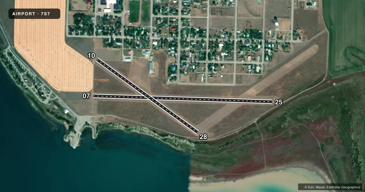
Runways & pattern
Full pagePattern entry · RWY 10
LEFT TRAFFIC| Runway | Heading (°M) | Length | Surface | Traffic |
|---|---|---|---|---|
| 07/25 | 74° / 254° | 3,075 ft | TURF | 25 R |
| 10/28Favored | 108° / 288° | 2,140 ft | TURF | 28 R |
Runway end performance
| End | TORA | TODA | ASDA | LDA | VGSI | Approach lights | Obstruction |
|---|---|---|---|---|---|---|---|
| 25 | — | — | — | — | — | — | 15', road, 40' from thr, 0' R of cntrln, slope 3 |
| 10 | — | — | — | — | — | — | 24', bldg, 550' from thr, 125' R of cntrln, slope 22 |
| 28 | — | — | — | — | — | — | 36', trees, 300' from thr, 0' R of cntrln, slope 8 |
Declared distances in feet. TORA = takeoff run available, TODA = takeoff distance, ASDA = accelerate-stop, LDA = landing distance.
Airport sketch
Runways drawn to scale from FAA survey coordinates, rendered over satellite imagery. Not for navigation.
Approaches & charts
Services on the field
Fuel grades, oxygen, maintenance, ramp storage and lighting — as declared to the FAA by the airport operator.
Fuel & services
- Fuel
- Not available
- Oxygen (bottled)
- Not available
- Oxygen (bulk)
- Not available
- Airframe repair
- Not available
- Power plant repair
- Not available
- Other services
- AGRI
Ramp & ground
- Transient storage
- Tie-down
- Landing fee
- No fee published
- Customs
- Not available
- Wind indicator
- Yes
- Segmented circle
- Yes
Fuel & FBOs
Cheapest 100LL and Jet A on the field and nearby. Always confirm with the FBO before taxi.
Airport notes
Surface conditions, obstructions, local procedures, lighting outages and other notes published with each FAA cycle.
General notes
- WATERFOWL ON & INVOF ARPT.
- FOR CD CTC SALT LAKE ARTCC AT 801-320-2568.
Approach & departure obstructions
- 0707/25 RWY 10/28 & RWY 04/22 MKD WITH W CONES FULL LEN.
- 04+10 FT TREES ON RWY CNTRLN EXTNDD.
- 07+24 FT TREES ON RWY CNTRLN EXTNDD.
- 10+375 FT WTR TWR 218 FT LEFT OF RWY CNTRLN 110 FT TALL RWY 10 END.
- 28+15 FT' TREES ON RWY CNTRLN EXTNDD.
Other notes
- ESTBD PRIOR TO 1959.
VFR map & nearby airports
VFR sectional. Tap any ICAO chip to open that airport.
Key facts · 7S7
Answer card- ICAO
- 7S7
- Name
- VALIER
- Location
- VALIER, MONTANA
- Elevation
- 3,826 ft MSL
- Traffic pattern altitude
- 4,826 ft MSL (1,000 AGL)
- Control tower
- Non-towered (use CTAF)
- Total runways
- 2
- Longest runway
- 07/25 · 3,075 ft
- Published ILS approaches
- 0
- Published frequencies
- 1
- Magnetic variation
- 18°
- Current flight rules
- VFR
- Current wind
- 160° at 4 kt
- Favored runway now
- RWY 10
Valier Airport (7S7) sits in Valier, Montana. The field elevation is 3,826 ft MSL. It has two turf runways. The longest is runway 07/25 at 3,075 ft. There is no control tower. CTAF is 122.9.
No ILS approaches are published here. Pattern altitude is not published, so a light piston pilot should plan on the standard 1,000 ft AGL unless the current Chart Supplement says otherwise. That puts the traffic pattern at 4,826 ft MSL based on the field elevation. The airport was established before 1959. Published remarks also call out white cones along the full length of runways 07/25, 10/28 and 04/22. The remarks note trees on the extended centerlines at several runway ends. There are 24-foot trees on the extended centerline for runway 07. There are 15-foot trees on the extended centerline for runway 28. There is also a water tower near the runway 10 end.
This is a high-elevation turf field in open country. Expect to pay attention to density altitude, runway surface condition and obstacle clearance on departure. Waterfowl are reported on and near the airport. There are no on-field FBOs listed. Check the current FAA Chart Supplement before you go. If you need current airport details or local operating notes, contact the airport operator or the FBO directly by phone.