METAR & TAF 8S0
8S0 does not publish a METAR.
Showing the nearest reporting station: KCTB (CUT BANK INTL) · 29.3 NM away. Conditions at 8S0 may differ.
METAR · KCTB
Observed 19:56Z
KCTB 231956Z AUTO 22012G19KT 7SM CLR 33/06 A2997 RMK AO2 SLP108 T03280061
- Wind
- 220° @ 12G19 kt
- Visibility
- 7 SM
- Temp / Dew
- 33°C / 6°C
- Altimeter
- 29.97 inHg
- Clouds
- CLR
- Density alt
- 7,872 ft
- Ceiling
- Unlimited
- Rules
- VFR
Airport info & contacts
Manager on record, flight service, ARTCC, attendance schedule and pattern altitude — published by the FAA and refreshed every 28 days.
Location
- From city
- 5 NM NW
- VFR sectional
- GREAT FALLS
- ARTCC
- ZLC · SALT LAKE CITY
- NOTAM facility
- GTF (NOTAM-D)
Airport manager
- Name
- TIM CONWAY
- Phone
- 406-444-2506
- Address
- PO BOX 200507, HELENA MT 59620
Flight service · Hours
- FSS GTF
- GREAT FALLS1-800-WX-BRIEF
- Attendance
- Unattended
Frequencies
Tap any row to copy the frequency to your clipboard.
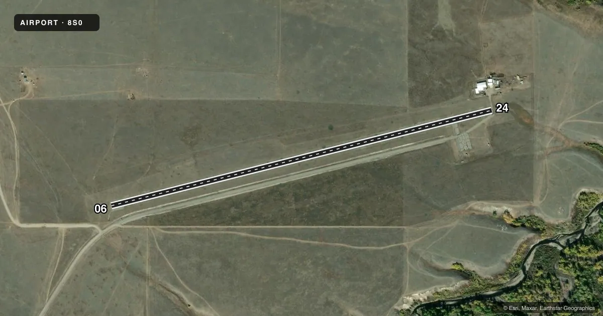
Runways & pattern
Full pagePattern entry · RWY 24
LEFT TRAFFICAirport sketch
Runways drawn to scale from FAA survey coordinates, rendered over satellite imagery. Not for navigation.
Approaches & charts
Services on the field
Fuel grades, oxygen, maintenance, ramp storage and lighting — as declared to the FAA by the airport operator.
Fuel & services
- Fuel
- Not available
- Oxygen (bottled)
- Not available
- Oxygen (bulk)
- Not available
- Airframe repair
- Not available
- Power plant repair
- Not available
Ramp & ground
- Transient storage
- Tie-down
- Landing fee
- No fee published
- Lighting schedule
- SEE RMK
- Beacon schedule
- SS-SR
- Beacon
- White / Green (civil land)(WG)
- Wind indicator
- Yes
- Segmented circle
- No
Fuel & FBOs
Cheapest 100LL and Jet A on the field and nearby. Always confirm with the FBO before taxi.
Airport notes
Surface conditions, obstructions, local procedures, lighting outages and other notes published with each FAA cycle.
General notes
- IRREG SNOW REMOVAL.
- LIVESTOCK ON & INVOF ARPT.
- FOR CD CTC SALT LAKE ARTCC AT 801-320-2568.
Lighting notes
- ACTVT MIRL RWY 06/24 - CTAF.
Approach & departure obstructions
- 06NSTD MARKINGS RWY 06/24. NSTD CNTRLN STRIPING, NO RWY EDGE LINES, NO MKR BARS.
VFR map & nearby airports
VFR sectional. Tap any ICAO chip to open that airport.
Key facts · 8S0
Answer card- ICAO
- 8S0
- Name
- STARR-BROWNING AIRSTRIP
- Location
- BROWNING, MONTANA
- Elevation
- 4,656.5 ft MSL
- Traffic pattern altitude
- 5,656.5 ft MSL (1,000 AGL)
- Control tower
- Non-towered (use CTAF)
- Total runways
- 1
- Longest runway
- 06/24 · 4,051 ft
- Published ILS approaches
- 0
- Published frequencies
- 1
- Magnetic variation
- 18°
- Current flight rules
- VFR
- Current wind
- 220° at 12 kt
- Favored runway now
- RWY 24
Starr-Browning Airstrip is in Browning, Montana. The field elevation is 4,656.5 ft MSL. It has one runway, 06/24, which is 4,051 ft long and asphalt. There is no control tower. No ILS approaches are published here.
The pattern altitude is not published. Use the standard 1,000 ft AGL pattern unless the current Chart Supplement says otherwise. That puts the light piston pattern at about 5,656.5 ft MSL based on the field elevation. CTAF is 122.9. The runway lights on 06/24 are pilot-controlled through CTAF.
There are no on-field FBOs listed in the facts, so plan on verifying services before you go. The published remarks matter here. Livestock are reported on and near the airport. Snow removal is irregular. Runway 06/24 also has nonstandard markings, including no edge lines and no marker bars. For clearance delivery, contact Salt Lake ARTCC at 801-320-2568. This is a high-elevation field in northern Montana, so performance planning matters. Check density altitude, runway condition and winds before departure. If you need current operational details, call the airport operator or check the current FAA Chart Supplement.